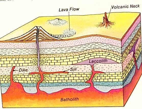
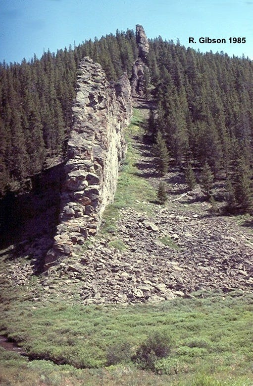
A dike is a narrow tabular body, usually formerly molten, that has forced its way through earlier rocks in a discordant, cross-cutting manner. This one is near Willow Creek Pass in northern Colorado, due west of Rocky Mountain National Park in the eastern Rabbit Ears Range (or western Never Summer Range, if you prefer). It intrudes shales and sandstones of the Coalmont Formation, which were deposited during Paleocene and early Eocene time, about 55 million years ago. So the dike must be younger than that since it cuts across those rocks.

The dike is probably Oligocene in age, around 24 to 28 million years old (Toth and Soullier, 2000, in Mineral Resource Potential and Geology of the Routt National Forest and Middle Park Ranger District of the Arapaho National Forest, Colorado: U. S. Geological Survey Professional Paper 1610). That’s a somewhat surprising age for igneous rocks breaking northern Colorado, because there wasn’t much going on after the end of the Laramide-Sevier Orogeny that uplifted the Rocky Mountains, ending about 50 to 60 million years ago (and the Coalmont Formation was among the last sedimentation related directly to that).
But at about that same time, 25 or so million years ago, a few hundred miles to the south in south-central Colorado (the San Luis Valley area) and especially further south, dividing what is now New Mexico in half in a north-south direction, the Rio Grande Rift was beginning to pull eastern New Mexico and adjacent areas away from points west in the Colorado Plateau, and plenty of igneous rocks are associated with that breaking.
Because dikes force their way through rocks, pushing them apart to intrude them, it’s easier for that to happen if the rocks are in a state of tension rather than compression. I’m sure it’s possible to have dikes forming in compressional conditions, but it’s far more common to infer that the stress system was extensional when and where we find dikes. So one possible explanation for the dike in northern Colorado, where there is definitely no obvious overt expression of the Rio Grande Rift, is that the tensional stress did indeed extend at least that far north, “encouraging” the dikes to form.
While that idea may seem reasonable, it’s probably wrong. When dikes reflect an extensional stress regime, they ought to be oriented perpendicular to that pull-apart stress. The north-south Rio Grande Rift is being pulled apart by an east-west stress system, so we might expect the dike in my photo, if my idea above is correct, to be oriented north-south. But as you can see on the map below, the dikes around Willow Creek Pass are oriented in directions ranging from almost east-west, to northeast-southwest, to south-southwest, apparently radiating from an intrusion at the appropriately named Radial Mountain (Tmi, Tertiary Miocene intrusive, on the map). So it’s more likely that the dike system is related to local cracks and weak zones, either pre-existing or (I think even more likely) produced by the domal uplifting caused by the intrusion, or both.

The dike rock is variable but more or less rhyolite, a silica-rich rock similar to that of Big Butte here in Montana. It is far more resistant to erosion than the shales and sandstones of the Coalmont Formation, so it weathers out in high relief like a wall as you see in this 1985 photo. The Coalmont also includes some coal, indicating swampy environments, and fresh-water fish fossils, indicating lakes.
Since my photo was taken almost 40 years ago, all the trees here were killed in a fire in 2020. Pass Creek is in the foreground.


