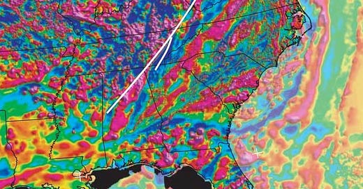
Roughly straight lines are common on the earth – relatively short segments of faults and rivers and more often are. But it’s unusual to find really long straight features, and when you do, they usually represent mega-scale tears in the earth’s crust.
The New York – Alabama Lineament is one of the longest, straightest features in any geological or geophysical data set in the world. The magnetic map of North America is where it was originally discovered. It appears to offset correlatable features by about 220 kilometers in a right-lateral sense, and some of those features are probably related to the Grenville Orogeny, about 1.1 or so billion years ago, so the fault that cuts them must be younger than that.
How much younger is debated – it could be fairly soon after, say 1.0 billion years ago, or as recently as some of the mountain building that raised the Appalachians, say 300 million years ago. But I think the most likely timing is between about 800 million and 600 million years ago because of the ages of the features that are cut, and because there are Cambrian sedimentary and tectonic features that appear to follow it as a pre-existing feature.
That time frame, 800 to 600 million years ago, coincides approximately with one of the “Snowball Earth” episodes, the Cryogenian Period of the Precambrian, from about 720 to 635 million years ago. Tectonic activity didn’t stop because most of the earth was covered by snow and ice. The supercontinent Rodinia, with what is now North America near its center, began to break apart about 800 million years ago, a process that continued until around 650 million years ago, when the broken pieces started to collide with each other again, in part to form the supercontinent of Gondwana (South America, Africa, Antarctica, India, Australia, Zealandia, and smaller pieces).

It's reasonable to infer that today’s New York-Alabama Lineament represents a 1400-kilometer-long strike-slip fault (like the 1200-km San Andreas fault in California) that formed as part of the Rodinia dismemberment. It’s near the margin of the old North American continental core, easier to break as the adjacent craton (strong continental block), Amazonia, perhaps shifted to the west (in the coordinates of the reconstruction above). Because the magnetic map shows analogous features on both sides of the Lineament, we’d conclude that if there was strike-slip motion along it, it stopped after about 220 km and did not end up ripping what is now the zone to the east from the core of the continent.
Other modern analogs include the the Altyn Tagh Fault (1200 km) between the Tibetan Plateau, the Tarim Basin in China, and the North Anatolian Fault (1500 km) in Turkey, and the Alpine Fault that’s ripping Zealandia apart.

The NY-AL Lineament is certainly not active today, but it may well serve as a potential weak zone that might affect the distributions of the relatively rare earthquakes in the eastern United States. The map above shows rather good correlation between the NY-AL Lineament and seismic activity in eastern Tennessee, but it should be noted that there are many other tectonic features there with this general trend that must post-date the NY-AL Lineament (Daniels and Peng, 2023, A 15-year-long catalog of seismicity in the Eastern Tennessee Seismic Zone (ETSZ) using matched filter detection: Earthquake Research Advances, Volume 3, Issue 1). The relationship between the lineament and seismicity in Tennessee was also described by Steltenpohl and others (2010, New York–Alabama lineament: A buried right-slip fault bordering the Appalachians and mid-continent North America: Geology 38 (6): 571-574).


