
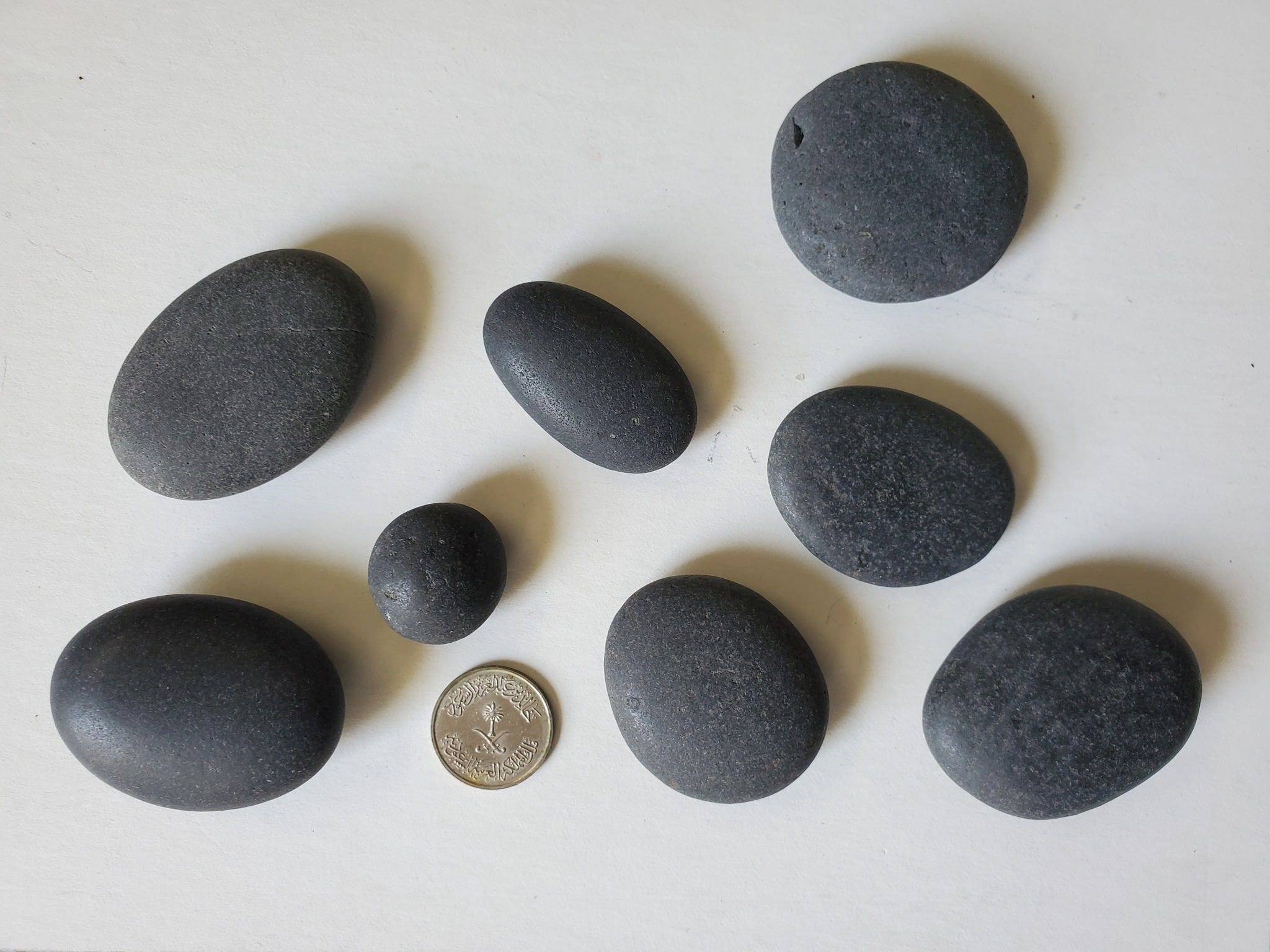
Basalt pebbles
From Vik, Iceland

Life in the USA is not normal. It feels pointless and trivial to be talking about small looks at the fascinating natural world when the country is being dismantled. But these posts will continue, as a statement of resistance. I hope you continue to enjoy and learn from them. Stand Up For Science!
For the mineral folks, there are two mineral photos at the end!
These well-rounded basalt pebbles are from the beach at Vik, near the southernmost point of mainland Iceland. They eroded from lava flows that erupted within the past 800,000 years. Saudi Arabian 10-halala coin for scale because I couldn’t find my Icelandic coins. The largest pebble is about 5.5 cm across.
Iceland is simple in terms of rock types: mostly basalt, glacial ice, and the products derived from them. It straddles the mid-Atlantic ridge, the spreading center rifting the crust apart, separating the Eurasian Plate to the east from the North American Plate to the west. The spreading center, where new oceanic crust is formed by upwelling magma, is tens of thousands of kilometers long, but there are few islands along it, and most are tiny. Why is Iceland there?
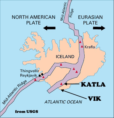
It seems to be a perhaps unique situation (at least today; there are older magmatic piles that may represent the same thing), where a hot spot in the mantle, which generates unusual volumes of magma, sits right under the spreading center, a weak zone that therefore allows more magma to rise, erupt and form the big island of Iceland. The Hawaiian Islands and Yellowstone are probably the other best-known hot-spot positions, but there are dozens around the world.
There are even others that coincide with spreading centers, but they appear to have either been smaller, less persistent in time, or if ongoing, to have had the spreading center move away from them, leaving Iceland as essentially a unique feature in the modern earth.
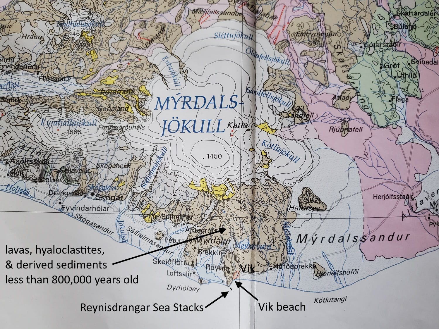
The spreading center at Iceland is complicated by being split into two branches, which you can see on the map from USGS. Katla volcano, in the eastern branch, is under the Mýrdalsjökull (that means “mire [bog] valley glacier”) on the geological map of Iceland below and labeled on the USGS map. Katla’s last major eruption was in 1918, and its earlier eruptions are probably the source of the basalt that formed the pebbles I collected.
The beach where I picked these rocks up is a black sand beach made of pulverized basalt. The basalt is fragmented in the usual way, by wave action on the beach, but a lot of it also probably results from explosive volcanic activity that shatters cooling magma (basalt, ash, obsidian) when it interacts with the coldness of glacial ice and water. (When such rocks solidify they are called hyaloclastites, from Greek for “broken glass.”) The larger cobbles and pebbles would be relatively recently carried onto the beach, eroded from solid basalt flows (not hyaloclastites) too recently to have been reduced to sand, but long enough ago to become very well rounded by the wave action on the beach. Larger pieces of rock round off faster than small ones, so these pebbles could be as young as a few hundred to a few thousand years or so old.
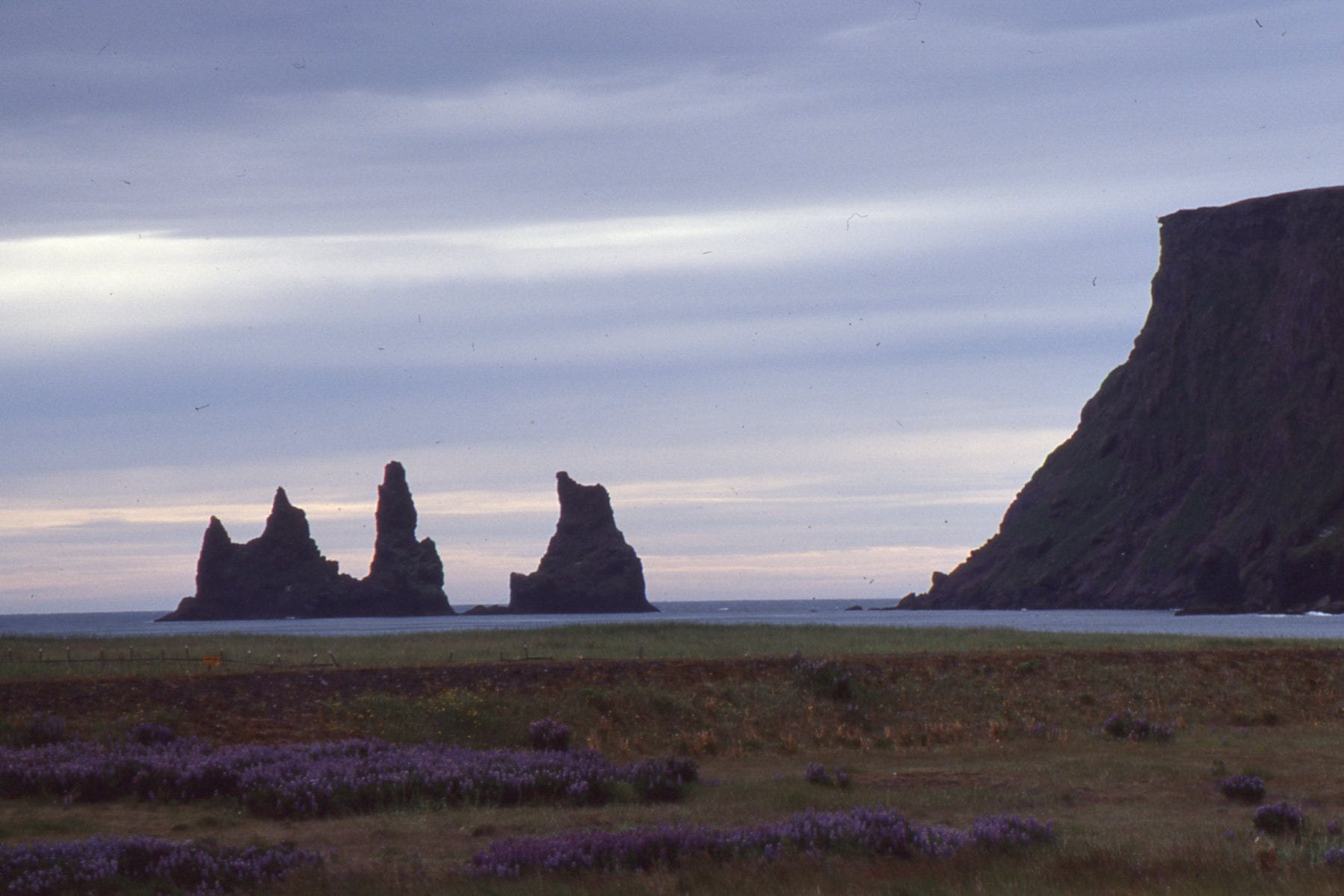
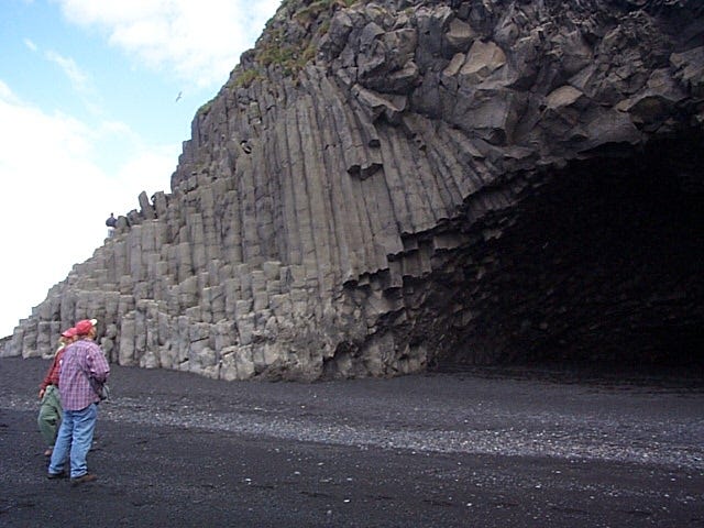
The photo above shows the view from the beach (the photo was actually taken from my hotel window) looking west toward the Reynisdrangar Sea Stacks, erosional remnants of materials erupted within the past 800,000 years. They contain interlayered basalt flows (columnar jointed, like those in the earlier photo), solidified ash falls (tuff), and pillow lavas (indicating eruption under water) and are about 66 meters (215 ft) high. Reynisdrangar means “Reynir’s pillars;” “reynir” means rowan tree, but a Viking named Reynir was the first settler in this area, so the name refers to him.
Icelandic mythology says two trolls were pulling a three-masted ship to shore one night, but it took too long and when the sun came up, the trolls and ship were all turned to stone.
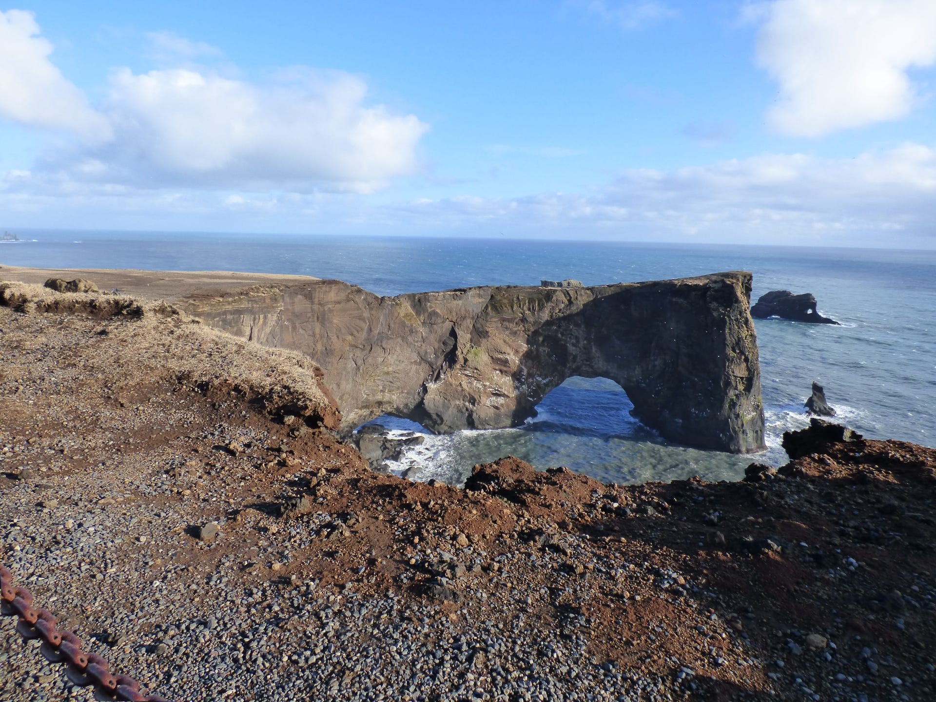
A little further west is Dyrhólaey (it means “door-hole [keyhole] island”), a classic sea arch. I lost my digital photos of Iceland, so the one here is a public domain photo by Shawn DeWolfe.
Edit: I wrote and scheduled this post some weeks ago. Since then, intense erosion has removed much of the beach at Reynisfjara. Search on that name to see the changes that resulted.
The rift
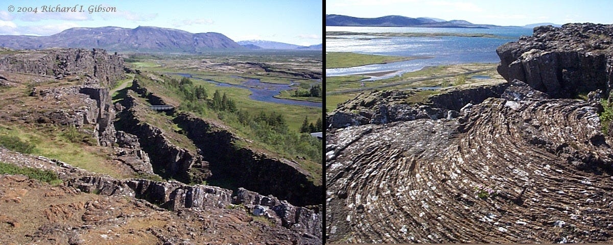
Ármannsfell, the 768-meter volcano on the skyline in the left photo, was created in eruptions about 150,000 years ago, when much of Iceland was covered by glacial ice. Consequently the rocks there include pillow lavas (erupted into liquid meltwater or glacial lakes, as smooth, blobby, pillow shapes) and hyaloclastites, broken, brecciated volcanic rocks indicative of explosive eruptions beneath glaciers or into water.
The mountain is crossed by later normal faults, some of which are expressed as the nick points on the skyline. The faults in Ármannsfell continue to the Þingvellir (Thingvellir, “assembly field” in Icelandic, where early Icelandic parliaments met) area in the foreground in the left photo where they break basalt flows younger than 9,000 years old, including some younger than 1,100 years old. The faulting expresses the ongoing extension, pulling apart of the crust, along the Mid-Atlantic Rift System which is exposed in Iceland. The cracks you see in the photo, which tourists walk through, are not the rift per se – the rift is a zone (in places, two zones) 50 or more kilometers wide, and these small faults are simply elements of the overall rift toward the western side of one of the main branches.
The photo at right shows a fine example of pahoehoe (from Hawaiian for “smooth, unbroken lava”). Its ropy surface develops as repeated relatively fluid flows (or the soft, partially solidified surface of one flow) impinge on each other and pile up, like pushing a carpet or dumping a pot of semi-molten chocolate on a slope. The rift is more or less the entire width of Þingvallavatn (“assembly field lake”), the lake in the distance beyond the flow in the foreground.
The overall pile of mostly basaltic rock that constitutes Iceland is generally younger than 3.3 million years.
Ármannsfell means “Ármann’s mountain.” Ármann was a beneficent guardian spirit in mid-17th-century Icelandic myth (Jón lærði, c. 1647), possibly a giant or troll who among other things was concerned about natural resource conservation, particularly soil erosion problems.
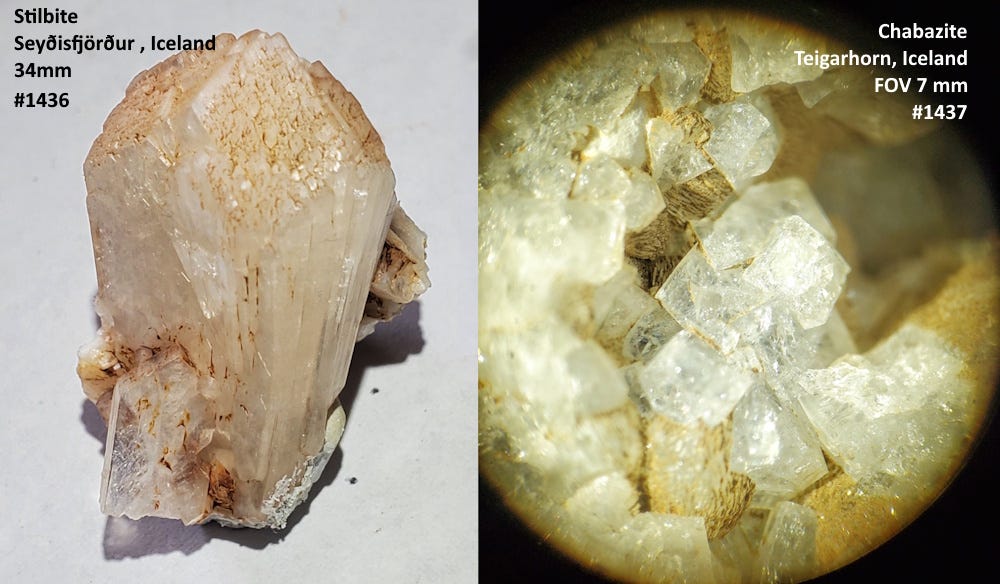
As a place dominated by basalt, it’s no surprise that many of the collectable minerals from Iceland are zeolites that formed in cavities in the basalt. The two examples here, stilbite (left, 34 mm specimen) from Seyðisfjörður, and chabazite (right; FOV 7 mm) from Teigarhorn, were both gifts to me from Chris Gammons and Colleen Elliott.
The rocks from Vik were collected and my photos were taken in 2004 when I was “working” as a geological Study Leader for a Smithsonian Journey.
Beautiful!
Such an interesting place -- the rocks, the waterfalls, the terrain -- glad I got to visit for a week in 2016. I bought the Geologic Map of Iceland there and have it pinned up on my wall.