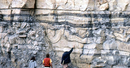
These folds in the Brushy Canyon Formation in West Texas are really the record of slumps in sediments that were soft – partially lithified, but still not really solid, brittle rock. The alternating tan and gray beds are sands and muds in the lower part of the Permian Capitan Reef complex that developed in West Texas and southeastern New Mexico about 260 million years ago.
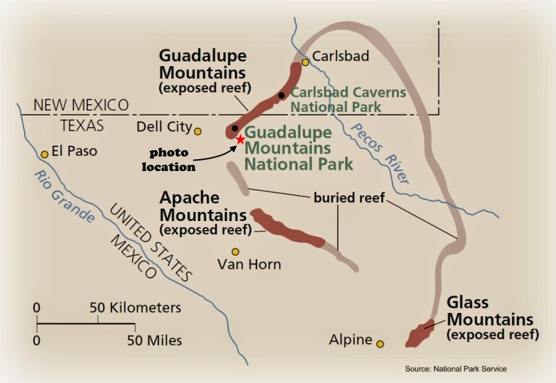
The reef grew on the fringes of an elongate lagoon about 150 miles long and 75 miles wide. For millions of years the central part of the lagoon subsided, probably a response to encroaching collisions by the northwestern corner of South America that was creating the huge Appalachian-Ouachita-Marathon fold belt and incidentally assembling the supercontinent of Pangaea.
The Brushy Canyon Formation represents early deposits, before the main part of the reef grew, on the northwestern slope of the subsiding basin. Sands in rivers and beaches were carried into the basin as submarine fans, probably mostly in the form of turbidity currents, flows of sediment-laden water that could essentially be like a slurry at times. Turbidity flows are like underwater rivers, and they sort the sediment quite well according to size. The tan material in the photo is mostly sand, and the gray is mostly mud (now solidified into shale) in positions that are essentially “overbank” areas to the central sandy flow.
When later thick, heavy turbidity flows come down the slope they can squeeze the partially solidified layers beneath them, folding them like a pile of rugs you push along with your foot. In places the later turbidity flows cut channels into the underlying sediments in addition to creating soft-sediment deformation like that you see here.
Alternatively but I think less likely, some of these features might be in part a consequence of dewatering in the sediment, with the upward arching resulting from water percolating upward through the sediment and bending it as it does so. When that happens, you often get up-arched features with pointed rather than rounded tops, called “teepee structures.” That’s not what you see here, so that’s why I think it’s an unlikely cause.
This photo is of an outcrop along U.S. Highway 62-180 south of Guadalupe Pass and near El Capitan scenic turnout. Taken on a Gulf Oil training trip in 1982.


In UK books your teepee structures are called flame structures. I guess because we don't have teepees over here. Same books distinguish between massive turbidity current deposits and fine silt drifting down during thousands of years between them. (Lots of Greywacke here forming S Uplands of Scotland.) Does this apply in your picture?
Thank you, this is interesting -- the only part of this I've visited is Carlsbad Caverns. I am a recent subscriber -- have you written about its connection to this previously? If so, I should find and go read that.