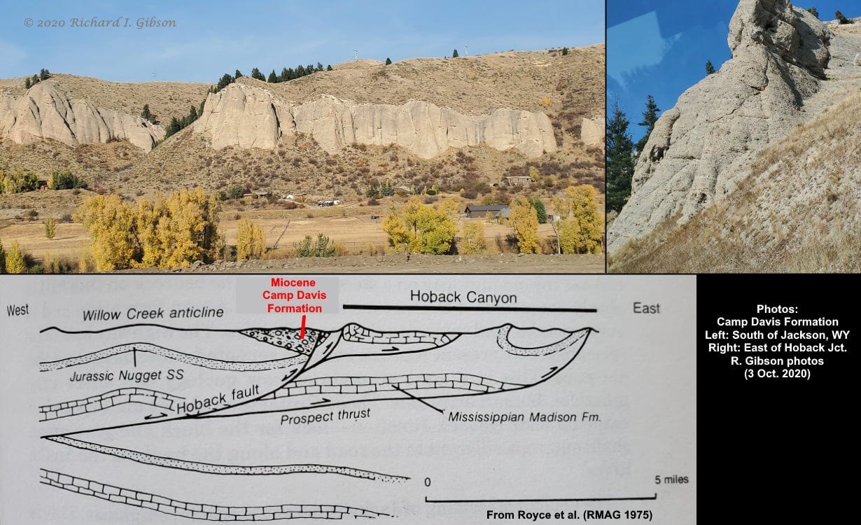
The Camp Davis Formation is a pretty local deposit, scattered around a few areas in the southern part of Jackson Hole, Wyoming USA, and the area east of Hoback Junction south of Jackson. Camp Davis, the University of Michigan’s Geologic Field Station, is about 6.5 km (4 miles) east of the junction and gives its name to these rocks.
The Camp Davis Formation is a gray conglomerate (interbedded with some siltstones, sandstones, and mud rocks; see Olson, 1987, Sedimentary evolution of the Miocene-Pliocene Camp Davis basin, northwestern Wyoming: Montana State University, Master’s thesis) whose age is late Miocene, 6 or 7 million years on the basis of fossils in it. The rocks record a complex tectonic history.
The Hoback Thrust Fault is one of the long low-angle thrust faults that comprise the Wyoming Thrust Belt, a more or less north-south zone of long linear slices of rock that were pushed eastward over younger rocks in western Wyoming. That thrusting is part of the Sevier Orogeny, a long-lived mountain building event that extends geographically from Alaska to southern Nevada and points south, and in time from about 165 to 80 million years ago, with some pushing and faulting continuing to as recently as 55 million years ago.
Nice overviews of the Sevier-Laramide thrust belt are here and here.
The Hoback Thrust Fault juxtaposed older rocks over younger in its first, eastward-pushing incarnation, but long after the compressive forces ended, western North America began to extend. This extension, pulling apart, is dramatically expressed as the basin and range in Nevada and western Utah, but it had impacts further into the continent as well. Here in northwestern Wyoming, the extension exploited the old thrust fault surface of the Hoback Thrust to slip down to the west as a normal fault, with a sense of movement opposite to that the Hoback Thrust originally displayed.
As the faulting brought a big chunk of territory down, it created a lowland, a basin, into which the adjacent uplands eroded. The Camp Davis Formation is the evidence of that erosion.
The cross-section below my photos is modified from Royse, Warner, and Reese (1975, Rocky Mountain Association of Geologists symposium) as published in Roadside Geology of Wyoming (Lageson & Spearing, 1988). The double-headed arrows on the line of the Hoback fault represent the two different periods of motion, one up to the east at least 55 million years ago, and another down to the west just 7 or so million years ago to form the basin in which the Camp Davis Formation was deposited.


