The map above is the satellite-derived gravity map of the Gulf of Tonkin, offshore Vietnam and China. This was part of a project I did to interpret the gravity data of the region for oil and gas exploration. The white dot, Yacheng Gas Field, is China’s largest offshore gas field and it began production in 1996 primarily to provide natural gas to Hong Kong. It initially contained an estimated 3 trillion cubic feet (tcf) of gas; for comparison, the entire United States consumes about 30 tcf of natural gas in a year.
The Gulf of Tonkin is in the offshore continuation of a huge fault system, the Red River Fault Zone that extends northwest across Vietnam and into Myanmar and beyond. The faulting is a consequence of the collision of India with Eurasia, which is essentially squeezing huge portions of Asia off to the southeast along major fault zones. This is shown in the image below.

The gravity map shows linear breaks (red lines) that might be parts of the extension of the Red River fault zone, and as white stars, locations that might be analogs to Yacheng Gas Field. The dark blue-purple areas are probably relatively thick piles of sedimentary rocks, which would be a positive factor for hydrocarbon exploration, both in terms of rocks that could generate oil and gas and those in which they could be trapped.
Except for the southeastern corner of the gravity map at top, where the edge of the continental shelf overwhelms the gravity signature, most of the water bottom in the Gulf of Tonkin is relatively flat. That means that the gravity anomalies, the highs and lows on this map, must reflect variations in geology. My job was to figure out what those geologic expressions were most likely to represent; some possible analogs are marked by white stars, but it takes more work and correlation with subsurface geology and other geophysical data sets to make those locations viable – the kind of effort that was done for this project.

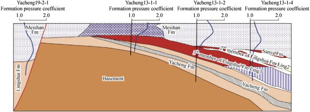
The big gas field is in a complex structural-stratigraphic trap in which the gas reservoir partially arches over a basement uplift. Yacheng Gas Field is largely depleted today, although still producing. The field was operated by British Petroleum for its partner China National Offshore Oil Corporation (CNOOC) until 2004 when CNOOC took over, and in 2013 BP sold its remaining 34.3% share to Kuwait Foreign Petroleum Exploration Company.
The faults in the Red River Fault Zone are at least moderately active seismically, with around 900 quakes in the past 900 years, but there have been no massive earthquakes in recent years (Nguyen and others, 2019, Investigation of long-term and short-term seismicity in Vietnam: J. of Seismology, 23:5).
This gravity map was derived though a mathematical transform of measurements of the sea-surface height, which with enough repeat measurements approaches the ideal shape of the earth (the geoid) in water areas. Variations from that ideal reflect variations in geometry of the sea floor and geological variations in the rocks.


Very impressive research and analysis.
Question: what is the theory of co-control of source and heat?