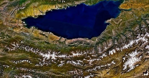
Issyk-Kul in Kyrgyzstan is the seventh deepest lake in the world, the tenth largest by volume, the second largest salt lake in area (after the Caspian Sea; but these ranks vary a lot because salt lakes also tend to be somewhat ephemeral if they are shallow), and the second largest high mountain lake (after Lake Titicaca). It’s 182 km (113 mi) long and 668 meters (2,192 feet) deep, at an altitude of 1,601 meters (5,272 feet). Issyk-Kul is an endorheic lake, from Greek words meaning “flow within,” because it has no outlet to a stream that ultimately reaches the sea. It’s there because India collided with Eurasia.

Issyk-Kul lies in a basin between branches of the Tien Shan mountain system, which in turn is part of the overall Alpine-Caucasus-Himalayan system that reflects ongoing collisions between parts of the former supercontinent, Gondwana, and Eurasia, all the way from Iberia to Indochina. But it has an even older heritage.
One of the earliest phases of Gondwana break up is called “Caledonian,” which strictly speaking ought to be reserved for the collisions between North America, western Europe, and a slice of Gondwana (Avalonia) that took place in Ordovician to Early Devonian time, about 490 to 390 million years ago. Caledonia was the Roman name for northern Britain, mostly Scotland, but sometimes (confusingly), “Caledonian” is used to refer to other, largely unrelated (or at least disconnected) tectonic events that happened at roughly the same time.
Granites in the northern Tien Shan are dated to 456 to 420 million years ago (Ordovician to Silurian, about the same time as some of the traditional Caledonian Orogeny), but they reflect amalgamation of an early version of the Kazakhstan Craton east of the present-day Ural Mountains, when the Kazakhstan Craton was unconnected and not even very close to what is now Europe, and the Ural Mountains did not even exist (De Grave and others, 2012, Thermo-tectonic history of the Issyk-Kul basement: Gondwana Research, 23, p. 998).
The earliest ancestral Tien Shan orogen (mountain belt) formed during Permian time, around 240 million years ago, when one of the blocks that now comprise western China (Tarim) collided with the earlier-formed Kazakhstan Craton. Soon after that, Kazakhstan and Siberia collided with Europe (Baltica) to make the Ural Mountains, part of the formation of Pangea. That amalgamation created a wealth of tectonic weak zones that could be – and were – reactivated over time.
The modern Tien Shan mountains, and the basin occupied by Issyk-Kul, formed when India collided. This continent-continent collision has had far-flung effects; Issyk-Kul is nearly 2,000 km (1,300 miles) from the edge of the Indian-Eurasian collision, but the basin that holds the lake probably dates to Oligocene to Miocene time (around 23 million years ago) and its development is continuing, as indicated by modern active seismicity in the region. India is still pushing against Eurasia and breaking distant parts of the crust ahead of it.
The Tectonic Map of the Soviet Union above is from Atlas SSSR (Moscow 1984), annotated by Gibson, and shows Issyk-Kul near the southeastern edge of the Kazakhstan Craton (KAZ). India and the Tarim block of China are off to the south and southeast of this map.
Issyk-Kul never freezes despite its high altitude. Its name means “warm lake” in the Kyrgyz language. When I worked on this area as part of my tectonic analysis of the magnetic map of the former Soviet Union, it was evident that there is a deep basin there, but it is underlain by intensely magnetic rocks, probably volcanics. And because of the tectonic story, this has probably been a relatively high-standing region for a long time. Even if (as is likely) there’s a relatively thick pile of sediments there (eroded from those high-standing mountains nearby), it’s not likely that they are prospective for oil and gas because there was not likely enough life in the high mountains for the past 10 million years or so to shed much organic material into the Issyk-Kul basin. That’s good news for this relatively pristine and beautiful high mountain region, even though there is a productive oil province just 300 km to the southwest, the Fergana Basin. That basin is broader, lower, and had a longer and earlier history of sedimentation.
“Tien Shan” is from a Uyghur name that means “mountains of god.”


Very interesting read, thank you.
Never heard of it. Good to know.