


Life in the USA is not normal. It feels pointless and trivial to be talking about small looks at the fascinating natural world when the country is being dismantled. But these posts will continue, as a statement of resistance. I hope you continue to enjoy and learn from them. Stand Up For Science!
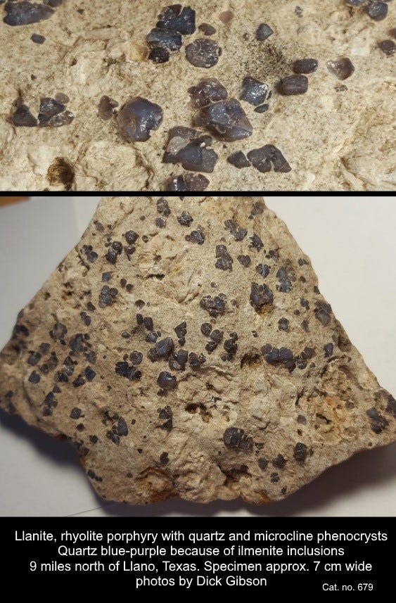
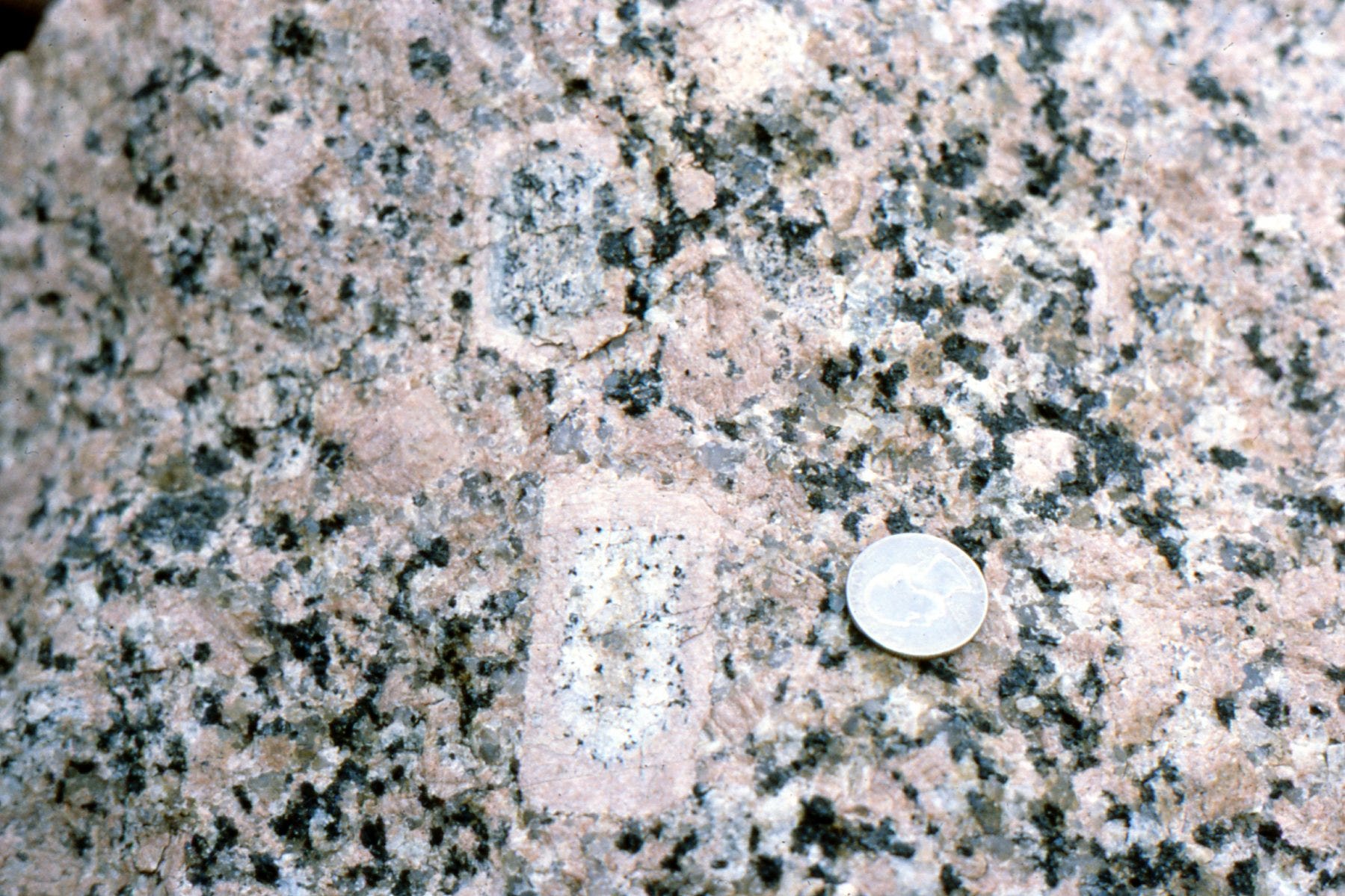
Blue quartz is uncommon and is often colored by inclusions of unusual minerals like crocidolite, tourmaline, or dumortierite. The purplish-blue quartz here, from north of Llano, Texas, is colored by inclusions of ilmenite (iron-titanium oxide) whose size also allows some of them (the smaller particles) to produce Rayleigh scattering of bluer wavelengths (Zolensky and others, 1988, Origin and significance of blue coloration in quartz from Llano rhyolite (llanite), north-central Llano County, Texas: Am. Mineralogist, Volume 73, pages 313-323).
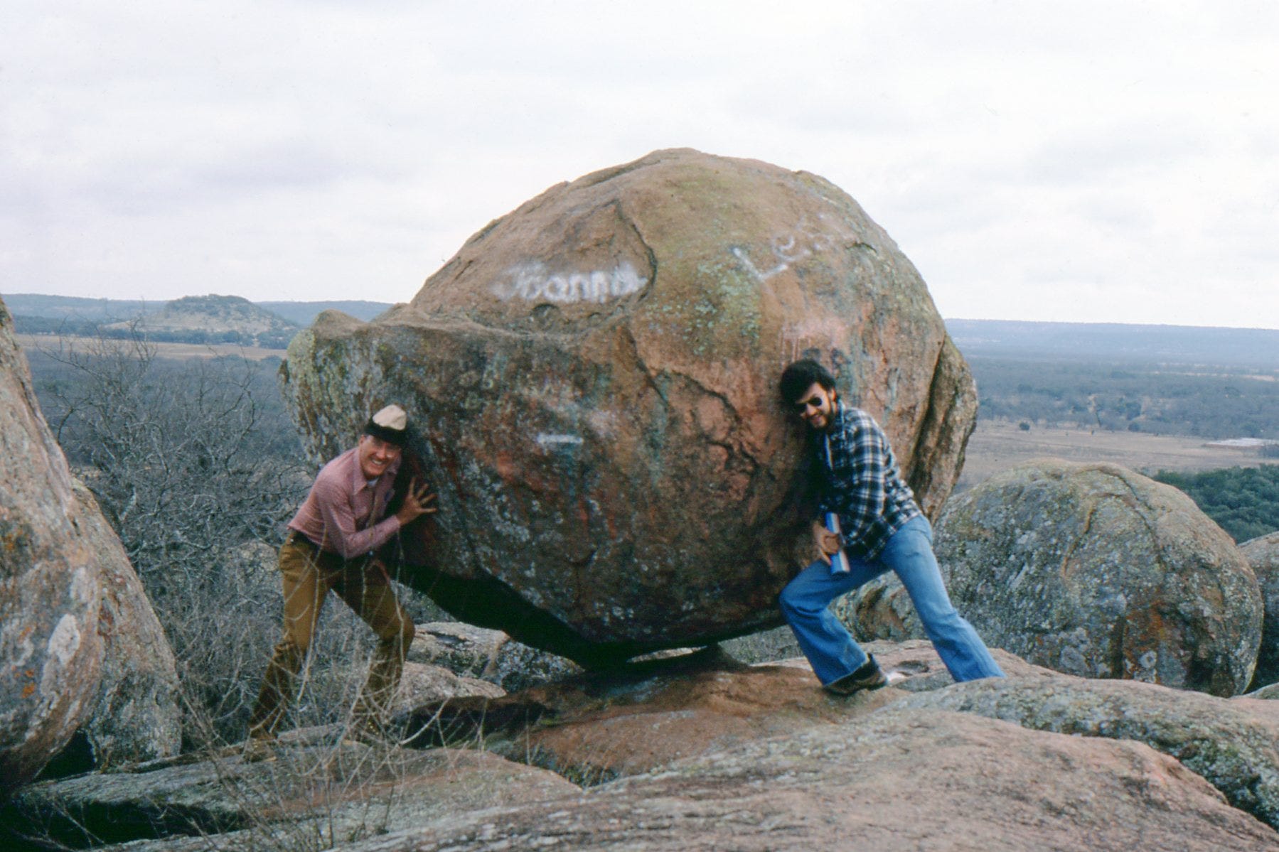
This rock is called llanite for its occurrence in the Llano Uplift of central Texas, and although similar rocks are found in other parts of the world, the variety name llanite really only applies to this location. On a sunny day, the blue quartz in the rocks has an opalescent sheen that sometimes seems to “wink” at you from the outcrop.
The phenocrysts (“showing” or “visible” crystals) of blue quartz in the llanite are supposed to be “beta quartz,” a high-temperature, higher symmetry form of quartz that can crystallize only above 573°C. In fact, it cannot even exist at surface conditions and pressures, so all “beta quartz” is actually a pseudomorph (“false form”) of regular quartz that has formed as the original beta quartz cooled but retained the crystallography of the beta quartz.
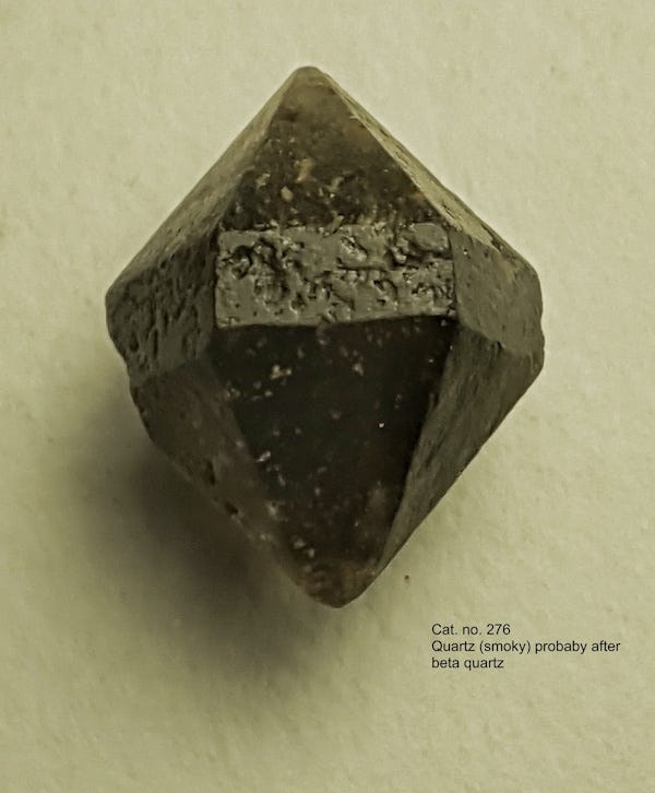
The little crystal above (not from Llano; probably from New York) is probably one such pseudomorph. Technically, since I knew you wanted even more jargon, it’s a paramorph rather than a pseudomorph, because while the crystal structure has changed, the chemistry has not. The essentially perfect hexagonal symmetry of this crystal marks it as a beta-quartz shape, versus the lower (trigonal) uneven symmetry typically displayed by normal quartz. It’s possible for normal trigonal quartz to have equally developed faces that appear fully hexagonal, but it’s unusual.
Generally speaking, the llanite rock is a rhyolite porphyry – rhyolite meaning pretty high in silica (a granite-like composition) and formed at or near the surface of the earth, and porphyry meaning it has two grain sizes – a fine matrix, with larger crystals of quartz (and microcline feldspar) suspended in that matrix. This implies that there were two periods of cooling, one at deeper depths where it took the larger crystals a longer time to cool (and grow), followed by a later, quicker period of cooling, so the matrix crystallized so fast the grains are very small, but the larger, older grains are still there within the matrix.
All that cooling happened about 1,093,000,000 years ago (almost 1.1 billion; Helper and others, 1996, Virtual geomagnetic pole position from 1.1 Ga intrusive rocks of the Llano uplift, central Texas: Geological Society of America, Abstracts with Programs, v. 28, p. 18.) during a time called the Grenville Orogeny (orogeny means mountain-building) when what is now central Texas was amalgamated to the main part of the North American continent. The llanite was probably an aspect of the intrusions of the Town Mountain Granite, which has similar age but crystallized at greater depth. It’s part of a long belt that extends with some discontinuity to central Tennessee, through Kentucky and Ohio, then northeast across Ontario, Quebec, and into Labrador. Rocks now in southern Scandinavia were part of the Grenville mountain belt, the result of a collision between continental masses that was assembling the supercontinent Rodinia over a long period of time, from about 1,250 million years ago to 980 million years ago.
The llanite, in the form of a narrow dike, intruded older rocks toward the end of the Grenville Orogeny. The mountain belt continued into Mexico, and rocks of similar age are found in Australia and Antarctica as well as South America today. Exactly how those rocks fit into the big picture is still debated, but one version of the assembled continent of Rodinia is shown below.
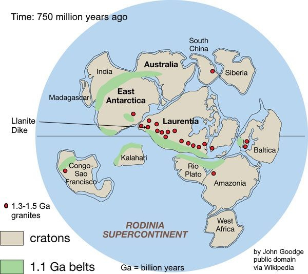
This reconstruction (others exist) shows Rodinia about 750 million years ago, just before it began to break up. “Rodinia” is from Russian for “motherland,” or “to give birth,” alluding to this continent’s early place in the rifting-collision cycles that have followed called Wilson Cycles with respect to ocean basins, for J. Tuzo Wilson. Even so, Rodinia was probably preceded by at least one earlier supercontinent, named Columbia.
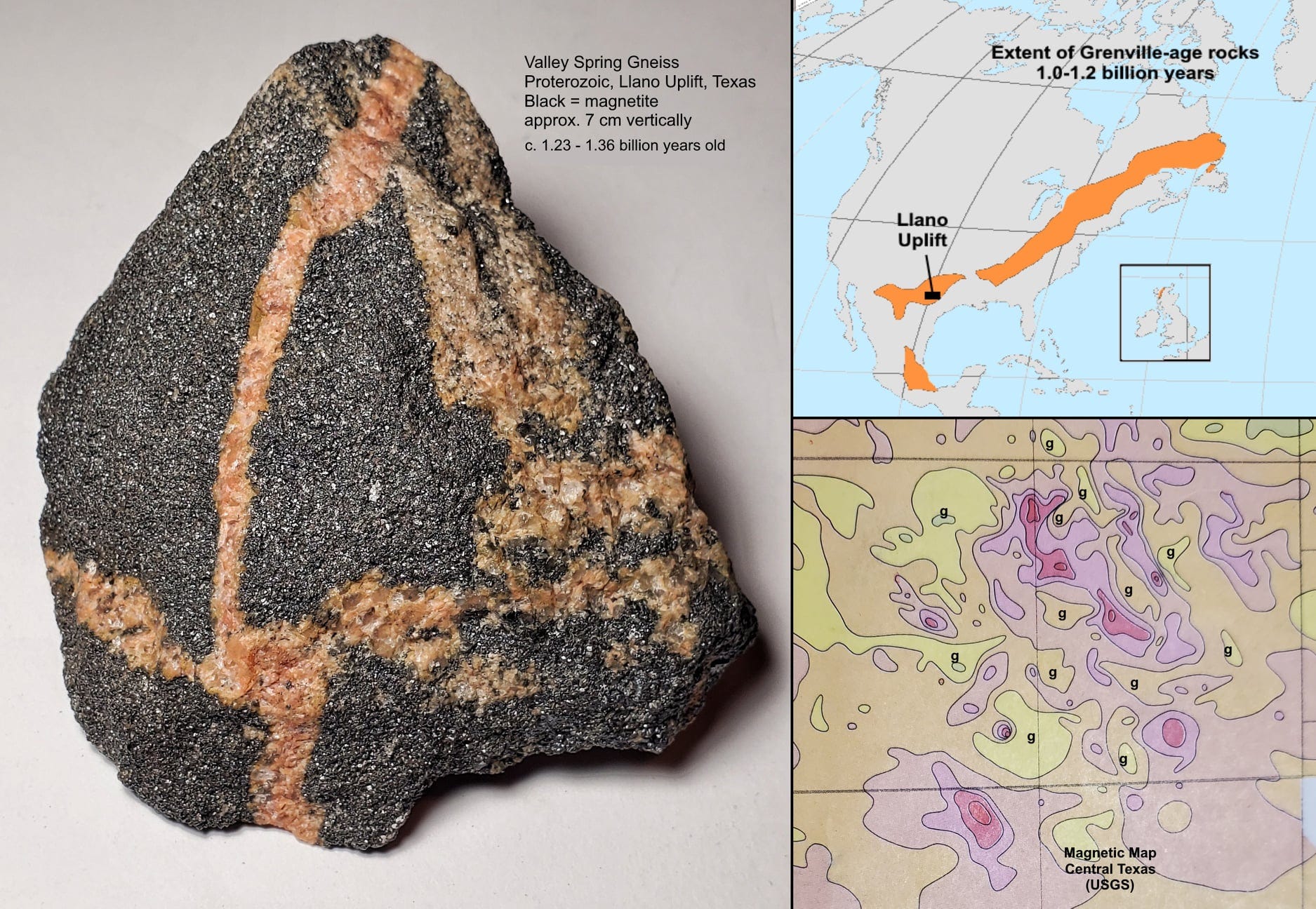
The oldest Llano rocks, the Valley Spring Gneiss, are mostly quartz- and feldspar-rich, more or less the composition of granite, but their origins were probably as diverse as granitic intrusions, rhyolitic volcanic rocks, and “dirty” sandstones (which means they had stuff in them besides resistant quartz that had not yet weathered out). These are the rocks the llanite dike intrudes. The age range for these rocks is about 1.36 to 1.23 billion years – a span of at least 114 million years, so it would be unreasonable to expect them to be uniform. See Reese et al. (2000, Mesoproterozoic chronostratigraphy of the southeastern Llano uplift, central Texas: GSA Bulletin v. 112; no. 2; p. 278–291) for a report on the age dates.
Whatever the original rocks were, they were metamorphosed multiple times. The last significant time was about 1.1 to 1.2 billion years ago, not long after the last original protoliths (“first rock,” the stuff that was metamorphosed) formed. That was the Grenville Orogeny, one of the major early collisions to affect eastern and southern North America.
A long, relatively narrow continental strip (now called the Grenville Terrane) collided with the old North America in a belt at least from Labrador to New Mexico and on into Mexico. There might have been additional collisions with pieces of continents that are now incorporated into Central and South America. But in what is now Central Texas, rocks in the old basin that lay on the flank of North America (underpinned there by the Valley Spring Gneiss), plus some magmatic island arcs, plus some slices of actual oceanic crust were all pushed to the northwest (in present-day geographic coordinates) over the older Valley Spring Gneiss and thereby added to North America. Those rocks, deeply eroded, now crop out in the Llano Uplift.
The collision was intense enough that there was likely some partial melting of the rocks during high-grade metamorphism, and combined with the more usual subduction-related magma, some fairly large granitic bodies (age about 1.0 billion years) were intruded into the older rocks (age 1.36 to 1.2 billion years). The granite outcrops in the Llano area as Enchanted Rock and other broad dome-like features.
The granites are pretty standard, quartz, feldspar, mica, some dark minerals like hornblende, and some magnetite. Generally, granite is a lot more magnetic than almost any sedimentary rock, but it’s all relative, and here, the Valley Spring Gneiss surrounding the granite has some zones that contain enough magnetite that they were mined sporadically for iron from 1890 to 1958.
In some places the stringers of pure magnetite are many tens of feet long and a few feet thick. One piece is in my photo above – the black is magnetite, and the veins crossing it are small granitic dikes.
Besides making for nice specimens of magnetite, another consequence of all this is that the aeromagnetic map of central Texas shows magnetic lows where the granitic bodies intrude versus magnetic highs where the magnetite-rich Valley Spring Gneiss is present. In the magnetic map at lower right above, the “g” letters indicate where it would be most likely to find granite, either on the surface or in the subsurface. The red shades on that map probably correlate with locations of magnetite-rich Valley Spring Gneiss.
Llano is Spanish for plain.
When I saw your map showing this Grenville belt going across Ohio, I had a look at my "Bedrock Geologic Map of Ohio" to see if it's noted on there. It is, but only on the cross section, since it's not exposed. Thank you for the chance to figure something out with this map, which I admit I mostly have for the novelty of it.