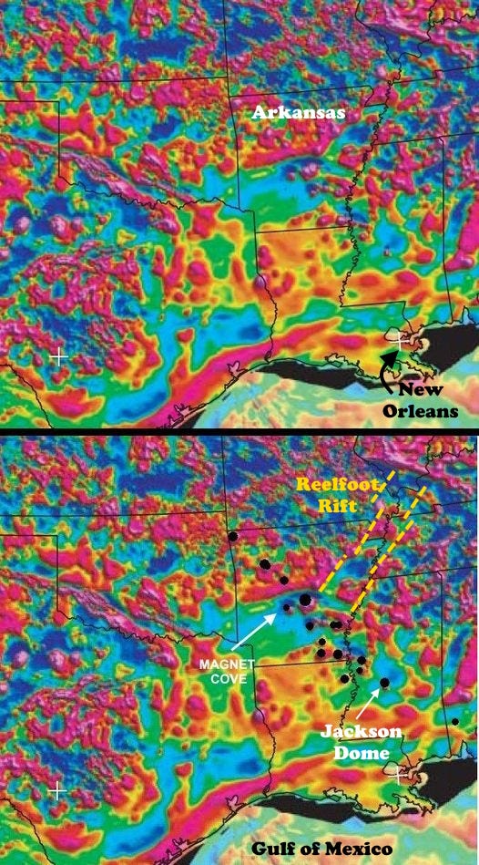
There’s a string of intense circular magnetic anomalies extending northwest-southeast across Arkansas, into Mississippi and near to Mobile Bay. They are most reasonably interpreted as igneous plugs, things like the necks of volcanoes but generally, down fairly far in the subsurface. (Highlighted as black dots in the lower copy of the magnetic map below.) A few of them, including Magnet Cove, Arkansas, reach the surface so we know they are indeed igneous bodies, in that case a carbonatite. The one in central Mississippi beneath Jackson has been drilled into, and the structure associated with it is called Jackson Dome. It's also probably a carbonatite, but it's a little younger, around 75 million years.
Carbonatites are often associated with rifting within continents. If this line of igneous bodies represents a rift system, it’s pretty narrow. Or it might represent a linear crack within a slightly oblique shear zone, not really quite a pull-apart rift like we see in East Africa today (where there are also carbonatites).
The age of the intrusion at Magnet Cove is about 90 to 100 million years, Cretaceous time. The linear nature of this string of intrusions suggests various possible origins. One idea is that it represents the passage of the North American Plate over the Bermuda Hot Spot, making a track like the linear chain of Hawaiian Islands, but the ages and chemistry don’t really support that idea much.
Another idea is that there was some kind of rejuvenation of the rift (Reelfoot Rift) that underlies the Mississippi Embayment, an ancient (at least Cambrian, 500+ million years ago) feature that constrains the position of the lower Mississippi River from southern Illinois to the river mouth. To my view, while the igneous bodies might follow an old weak zone or crack, it’s hard for me to see it as related to that rift.
The NW-SE linearity could be construed as an aspect of the opening of the Gulf of Mexico, which formed when a small continental block (now Yucatan) pulled away from North America. Since Yucatan pulled and probably rotated a bit, there must have been some faults along its northeastern edge that would have accommodated the movement (see map below). The line of intrusions has been called a “leaky transform fault,” meaning a serious crack in the crust that allowed magma to rise along it. The big problem with this is the timing – the Gulf of Mexico was pretty much done opening by about 140 million years ago, 40 million years too soon for the “crack” along which these intrusions developed to have been related to the opening. But it MIGHT have been a later rejuvenation, similar to the idea of rejuvenating older weak zones related to the Reelfoot Rift.
Bottom line, there’s this very linear string of igneous plugs scattered over several hundred kilometers in Arkansas and Mississippi that developed about 95 million years ago, and we don’t really know for sure why.
I don’t think it’s completely clear how Yucatan moved away from North America to open the Gulf of Mexico. It might have been a relatively simple translation, from northwest to southeast (the black arrows on the map above, suggesting a new oceanic spreading center on the blue line), or there might have been a rotational component (the yellow arrow). Or some complex combination of both.
Carbonatites are often enriched in sodium and/or potassium, so aegirine, a sodium pyroxene, is often found in them.


