


Mapping: changes over time
Evolution of the geologic column

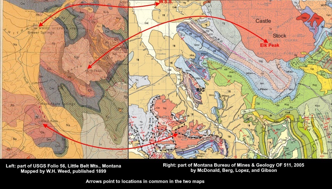
Here are two geologic maps of the same area south of White Sulphur Springs, Montana, one from 1899 and the other published in 2005. Both are more or less reconnaissance in nature, but we had more time (and better context, thanks to the older mapping) and better printing technology to make the 2005 map. I can say “we” because I helped a little with this, focusing on the small area around my initials, RIG, on the map.
The arrows correlate Black Butte, Elk Peak, and White Sulphur Springs on the two maps.
You can see how geologic mapping terminology has evolved. In the 1899 map, the formation label “Ab” means Algonkian Belt Formation. Algonkian was the old term for the younger Precambrian, a time period we now call Proterozoic, and it is now subdivided by age which is indicated by prefixes Z, Y, and X, from younger to older, equivalent to the Neoproterozoic, Mesoproterozoic, and Paleoproterozoic Eras. In the newer map, the “Algonkian” rocks are labeled Ys and Yg, because the Belt Formation is now a Supergroup of rocks, and those labels represent the Spokane and Greyson Formations respectively, of Mesoproterozoic ("Y") age within the Belt Supergroup.
Gray “Cm” on the older map means Carboniferous Madison. We still use the name Madison, but the Carboniferous Period is now subdivided into Mississippian (older) and Pennsylvanian (younger) ages, and the Madison Group includes Ml (Mississippian Lodgepole), Mmc (Mission Canyon), and Mbs (Big Snowy) formations. The United States is pretty much the only place that uses Mississippian and Pennsylvanian – in the rest of the world, they are Early/Lower Carboniferous and Late/Upper Carboniferous. Early/Late are used when you are talking about time, and Lower/Upper are for when you’re talking about rocks – but there’s a lot of slop in practice and conversational usage.
“K” means Cretaceous on both maps. “K” is used because C already was assigned to Carboniferous, and C with a bar through the letter means Cambrian. Cretaceous itself is from Latin creta, ‘chalk.’ We do try to avoid jargon confusion sometimes, if rarely. The names of the Cretaceous formations have changed, though – from Ky (Yellowstone Formation) to Kk and Kcg (Kootenai and Colorado Group) on the newer map.
Another change is in the younger rocks that are labeled with the initial symbol N on the older map, for “Neocene.” Ns means Neocene Smith River Lake Beds, and Ngr means Neocene granite (equated with Tg, Tertiary granite, in the Castle Stock at right). Neocene was used at a time when the Tertiary Period was broken only into Eocene (“dawn recent”) and Neocene (“new recent”). The period had other subdivisions (Paleocene, Eocene, Oligocene, Miocene, Pliocene, and Pleistocene Epochs), some of which were used more than others, and they are still used, but nowadays officially there are two periods in the time between the end of the Cretaceous (65 million years ago) and the start of the Quaternary (2.5 million years ago). Those two periods are Paleogene and Neogene. The “-gene” suffix in the newer names means “born,” versus the “-cene” suffix which means “recent,” so Paleogene and Neogene mean ancient born and new born, respectively. But on the newer map, all those time subdivisions are labeled with a “T”, simply for Tertiary. Confusing enough?

Although there are plenty of differences in detail, on the whole both maps do show essentially the same rocks and agree in their age assignments and orientations. Walter Harvey Weed (1862-1944), who did the 1899 geologic mapping shown here, was a consummate geologist and mapper despite the differences between these maps. He produced a huge geological study of Butte, an early analysis of the Elkhorn Mining District, a book on the geology and another on the geysers of Yellowstone, a report on the Judith Mountains, as well as comprehensive maps and reports on the geology of the Castle Mountains and the Little Belt Mountains. His 1905 book The Nature of Ore Deposits was one of the most important early texts of economic geology.
The generally NW-SE trend of the folds and faults and beds on the maps is an expression of the mountain building that affected western Montana about 80 to 55 million years ago. The edge of the resulting fold-thrust belt here near White Sulphur Springs swings around to the northwest and continues up to Glacier Park and for hundreds of miles further into Canada.
If you are interested in my other posts about the History of Geology, you can find 22 of them compiled into a downloadable PDF booklet (about 6 megs), here.
Super-informative! I suppose there is some kind of international standards-setting geologist body. Why can't America just adapt the international geology taxonomic conventions? Time we went to the metric system too!