Mumbai (Bombay) High oil field is the largest in India, at times producing close to half of all of India’s domestic oil. It was discovered by Russian exploration on behalf of India, began production in 1974 and reached its peak of production about 1998, when it yielded 265,000 barrels per day. By 2024, production had declined to about 134,000 barrels per day. For comparison, Prudhoe Bay, the largest oil field in North America, produced more than 2 million barrels a day at its peak in 1988 and still yields about 320,000 barrels a day in 2024. Ghawar Field in Saudi Arabia, the world’s largest, has been producing since 1951 and still has a capacity of something more than 3,500,000 barrels per day.
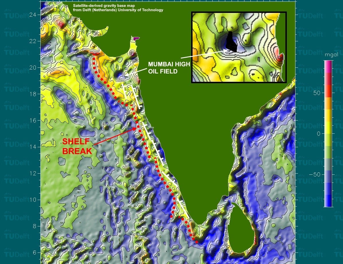
The map above, created by the Delft (Netherlands) University of Technology using satellite-derived measurements of the average height of the sea surface, shows calculated gravity values. The average height of the sea surface is proportional to the mass of the material below it – denser stuff pulls the sea surface down, lighter stuff allows it to rise higher. Thousands of passes by the satellite, which carries an extremely accurate (a couple centimeters) radar altimeter, eliminates the transient effects of waves and currents to give a real average. What’s left is mathematically converted to a map of gravitational attraction. It only works in water areas, so onshore India is blank in this map.
The blue colors, lows, indicate the presence of relatively low-density rocks in the subsurface, complicated by other contrasts such as water versus rock of any kind. That water-rock contrast is reflected by the gradient between the linear high (red, yellow, green) a bit away from the coast and the blue feature further offshore. I’ve marked that gradient with a red dotted line on this map, labeled “shelf break,” the zone where the water gets abruptly much deeper to the west.
The blue colors closest to shore, where the water bottom is flat and does not affect the calculated gravity signature, can be interpreted as thicker low-density sediments. Because they are somewhat linear and because the west coast of India is a rifted margin (India pulled away from Africa and Madagascar as the old supercontinent of Gondwana was dismembered), it’s reasonable to think those gravity lows are bounded by faults, shown on this map as my white lines with tick marks.
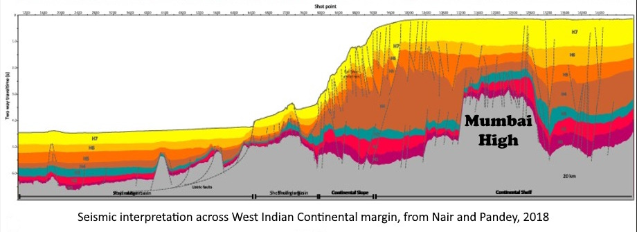
The strange feature here is the nearly circular gravity low (blue) offshore from Bombay (Mumbai). That low is the site of the Mumbai High oil field in an anticlinal (up-arched) fold in Miocene limestone. Such an uplift ought to show as a gravity high, because relatively higher-density rocks are brought toward the surface, but it’s just the opposite.
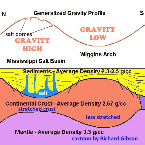
There must be some other explanation for the gravity low there. One possibility is that the sub-circular low is a blob of thicker continental crust extending down into the much denser mantle, therefore creating a relative gravity low while the top of it is actually a physical high, trapping the oil in the oil field. It might be a thick piece of crust left behind as India rifted away from Africa. The Seychelles, in the western Indian Ocean, is such a dismembered block of continental crust, and the Wiggins Arch in Louisiana and Mississippi is a similar feature related to the opening of the Gulf of Mexico, with a similar gravity expression: a gravity low coinciding with a physical high.

The subsidence and sedimentation history of the basin containing the Mumbai High is complex, but I think some workers see the effects of crustal stretching, compatible with variable-thickness blocks as I suggest above (for example, Pandey and others, 2016, Basement tectonics and flexural subsidence along western continental margin of India: Geoscience Frontiers 8(5) — but I do not imply that they agree with my interpretation).
Another possibility is that this gravity low represents an impact crater, called Shiva Crater, that might have coincided in time with the Chicxulub impact in Yucatan 65 million years ago. Apart from the somewhat circular shape (and in detail, it’s actually more rectangular), there isn’t much if any evidence for such an interpretation. Claims that shocked quartz (an indicator of impacts) is present have not been published, as far as I can tell, and most scientists don’t think this is an impact, but it hasn’t been completely ruled out either. When I was conducting a gravity & magnetics training program for the Indian national oil company, Oil and Natural Gas Corporation (ONGC) in Dehra Dun, India, in 1987, most of the 33 participants in the course (including several who had extensive direct experience with this oil field) didn’t think it was an impact. I think the best explanation is that this gravity low represents a small, thick blob of continental crust, relatively low in density compared to the upper mantle into which it extends downward, an analogy to the Wiggins Arch suggested above.
Even with Mumbai High Field, India imports about 88% of its oil. India is the largest importer of oil from Russia, which provides 38% of India’s oil imports, almost equal to imports from the Middle East (mostly Iraq and Saudi Arabia), which total 41% of Indian imports in 2024 (Reuters, article by Nidhi Verma, May 21, 2024).


Interesting explanation of satellite activity Richard. And the gravity anomalies. So much isn't known.
But....no mineral pictures like Steve Sorrells posts, lol!---oil doesn't take a good photo. I found some oil geodes near McLean, IL, once; Cool to find, but what a mess!
Not a bad find and not too shabby production, at least in the early years. I'm sure in the intervening decades "look-alikes" have been searched for in hopes of another discovery.