Navajo Lake in southwestern Utah, between Cedar Breaks and Bryce Canyon, is unusual in having neither a major input stream nor an outflow stream. It lies in a closed basin at 9,035 feet elevation, and most of its inflow is from springs and precipitation. Its original outflow to Duck Creek was dammed by a lava flow, so now water only exits the lake as groundwater through complexly channelized groundwater conduits. Despite that, it is not a salt lake; inflow and outflow circulate the water, just not through surface streams. See Wilson & Thomas, 1964, Hydrology and Hydrogeology of Navajo Lake, Kane County, Utah: USGS Prof. Paper 417-C for more information.
Navajo Lake lies on a long narrow north-south fault-bounded block called the Markagunt Plateau. That is one of several such blocks that comprise the western flank of the Colorado Plateau, where the relatively high Plateau steps down to the west along faults into the Basin and Range province. This breaking is mostly Cenozoic in age, and the rocks around Navajo Lake that underlie the hills in my photo, the Paleocene-Eocene Claron Formation (about 55 million years old) and related volcanic rocks, are mostly older than the faulting as indicated by their involvement in it.
The faults that bound the Markagunt Plateau, the Hurricane Fault system on the west and the Sevier Fault on the east, have different amounts of throw on them, so that the Markagunt actually slopes gently to the east. Its western flank is about 3,000 feet higher than its eastern part, opposite to the overall sense of displacement on the western Colorado Plateau.
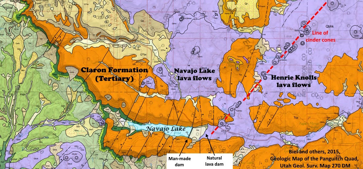
The faults and fractures that define the western edge of the Colorado Plateau allowed the eruption of basaltic lavas in this region, beginning about 5 million years ago and continuing to just 1,000 years ago at Panguitch Lake about 20 miles north of Navajo Lake. The Henrie Knolls lava flow that dammed Duck Creek and created Navajo Lake is not dated well, but is likely to be of similar young age, probably 1,000 to 2,000 years or so, but possibly as old as 60,000 years (Biel and others, 2015, Geologic Map of the Panguitch Quad: Utah Geol. Surv. Map 270 DM).
The Henrie Knolls lava flows are related to numerous cinder cones that have a remarkable northeast-southwest linear alignment, marked with a red dashed line on the map. It is subparallel to the known faulting in the region and likely marks a fault in the subsurface (Biel and others, 2015, cited above).

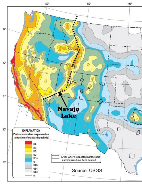
The faulting along the western Colorado Plateau has a complex heritage, but differences in crustal thickness between the thick Plateau and the thin Basin and Range are likely significant factors. The faulting is partly an accommodation of those thickness variations, compounded by a long history of deformation along that zone which today is the Wasatch Front to the north, around Salt Lake City. It is still active seismically, defining the Intermountain Seismic Belt that continues north into Montana.

Geologically speaking, Navajo Lake is destined to be even more ephemeral than most lakes. Erosion and stream piracy will probably breach its closed basin margin and drain it within a few million years at most. For now, it is prevented from draining via groundwater flow into a natural sink by a human-built dam that supplements the lava dam.
Markagunt is the Paiute word for highland of trees.


There is a nearby spring, Cascade Falls, which is a spectacular cliffside cave mouth or conduit drain from Navajo Lake. Definitely worth the short, scenic hike.
Here is a link to the Utah Geological Survey write up, with pictures.
https://geology.utah.gov/map-pub/survey-notes/geosights/cascade-falls/
Fascinating! Gibson always does a great job connecting geologic facts across regions and across time. He helps one see the big picture.