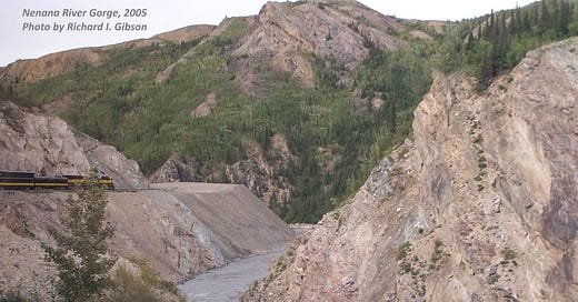
The Nenana River Gorge about 5 miles (8 km) south of Healy, Alaska, cuts through the northernmost part of the Alaska Range in central Alaska. The train in the photo is the Alaska Railroad (I’m taking the photo from a car well back in the train around the curve; this was on a Smithsonian Journey in 2005 where I got to serve as the “house geologist”).
Although these rocks are fairly well exposed, they are quite poorly understood because central Alaska is a mix-up of really diverse terranes that have been juxtaposed by complex tectonic activity for millions of years. The most recent (current) action is on the Denali and related faults, a long curving system of right-lateral strike-slip faults that is ultimately more or less the continuation of the Queen Charlotte and San Andreas fault systems. Very broadly, these faults are all moving rocks on their south or southwest sides to the northwest with respect to the main body of North America. For Denali, because of the curvature, it’s even more complicated.
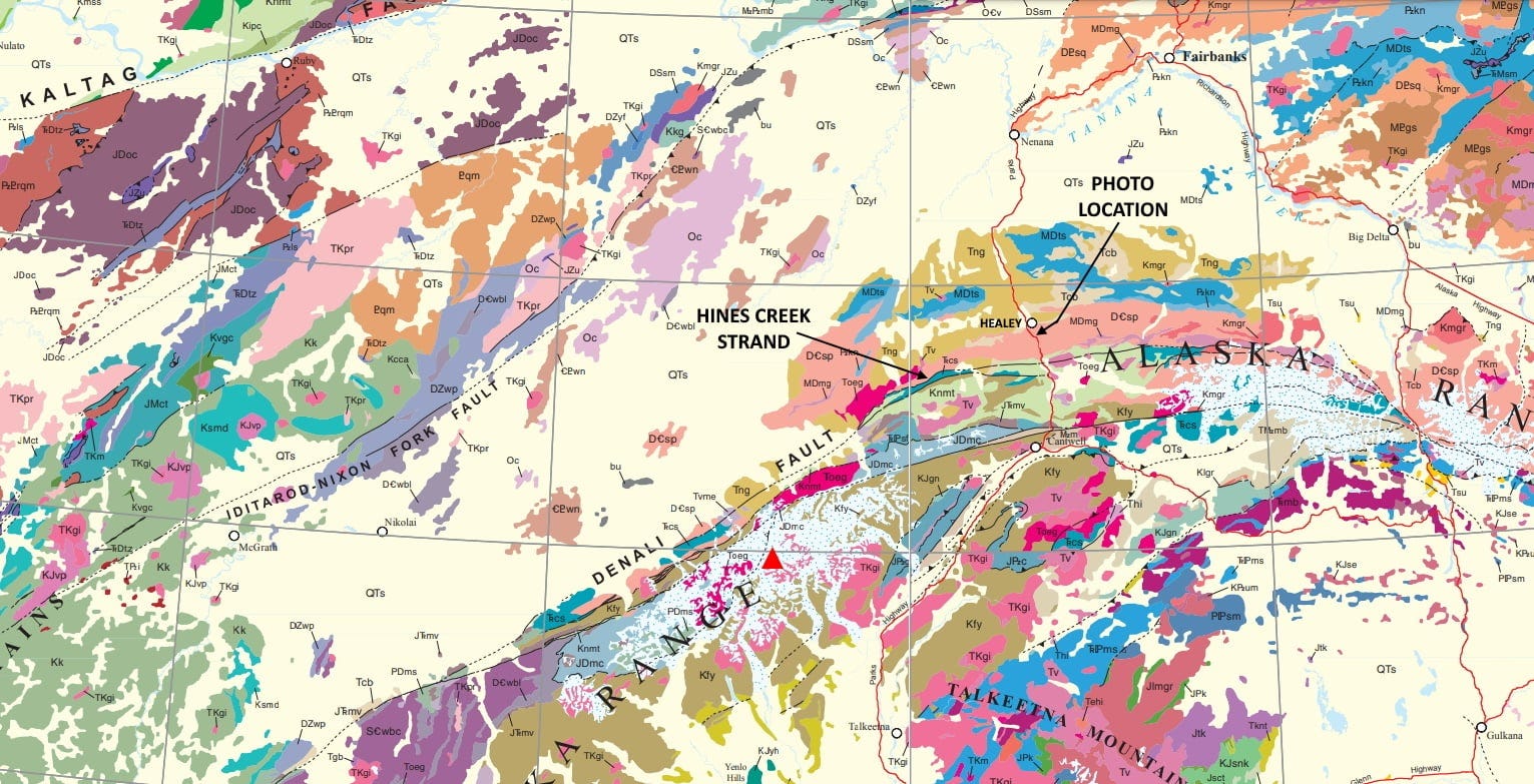
The rocks in my photo are highly weathered and probably altered schist and phyllite, weakly metamorphosed formerly sedimentary rocks like shales, siltstones, and sandy carbonates. For decades, they were mapped simply as “Paleozoic to Precambrian.” On the map included below (Wilson and others, 2015, Geologic Map of Alaska, USGS SIM 3340) they are the salmon-colored zone that crosses the Parks Highway (red line) south of the town of Healy. On this 2015 map they are labeled “DCsp,” Devonian-Cambrian schist and phyllite. It is the area just north of one of the main splays of the Denali Fault (I added the label “Hines Creek Strand” to that splay).

The rocks in the Nenana River Gorge in my photo are in a zone caught between two much larger terranes. The Yukon-Tenana composite terrane lies mostly northeast of the photo location, around Fairbanks at the top of the map, but it extends many hundreds of kilometers to the southeast, into Canada. It may have been originally part of North America that rifted off the western margin in Mississippian to Triassic time (another vague period, spanning more than 100 million years, about 320 to 220 million years ago), and that crashed back into the continent in Early Cretaceous time, maybe 130 million years ago.
South of the rocks in my photo, the Wrangell Terrane is another elongate block, hundreds of kilometers long. It lies mostly in coastal British Columbia and the Alaska Panhandle but probably extends into Washington State. The probable piece of Wrangellia in central Alaska south of the Nenana River Gorge is relatively narrow, strung out along the Denali Fault System.
Some maps show the salmon-colored zone, which includes the rocks in my photo, as the McKinley Terrane or Pingston Terrane or both, but it’s a relatively small bock squeezed between the larger Yukon-Tenana and Wrangellia Terranes.
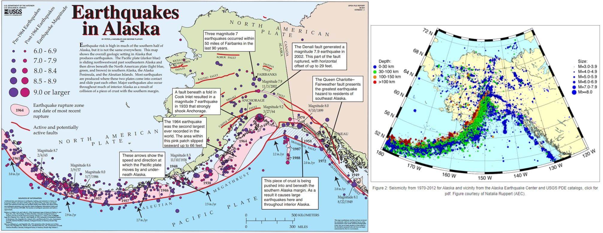
The Denali Fault got started perhaps as long ago as 70 million years, but it is still active and is one of the main producers of earthquakes in Alaska, reflecting the ongoing complex interactions among diverse blocks that are more or less part of North America now, and the Pacific Ocean plate, subducting beneath Alaska along the Aleutians and up into south-central Alaska. The seismic map from the USGS that I also include above shows only the large quakes (and only to 2002). Many, many thousands of earthquakes occur on these zones every year, and a more comprehensive illustration (from Atomic Energy Commission via IRIS) is to the right of the USGS map. Earthquake Insights has a post about a recent earthquake on the Queen Charlotte fault system, the faults that accommodate this stress in southeastern Alaska.
The Nenana River begins at the Nenana Glacier about 80 miles (130 km) east of Denali in the Alaska Range. Multiple glaciations carved the initial valley, and at times it was wide enough that during glacial retreats lakes formed as well as multiple stream terraces. The modern gorge, with its steep walls and overall V shape, is incised into the older glacial deposits by the post-glacial outflow in the Nenana River (Wahrhaftig, 1958, Quaternary geology of the Nenana River valley and adjacent parts of the Alaska Range: USGS Prof. Pap. 293). The origin of the name is uncertain.


Alaska in the summer is the ultimate vacation, imho. You bring back memories of Uganik lake, river and bay, Kodiak, years ago.
I'm just now learning geology so I hope this question doesn't seem idiotic. I always thought that the Earth was not a perfect sphere with conditions everywhere equal in terms of forces acting on its geology and plate tectonics. Gravitational forces, rotation, magnetic, etc might mean geology at the poles might be very different than at the equator. Reading your account brought this old speculation to mind again. Are there observed differences, common to both poles, in plate tectonics and crustal geology? Maybe circumpolar geology is kind of quiet or is it where illuminating insights are to be found? Dumb question maybe,?