
Shepard Formation
From the Belt Supergroup

Life in the USA is not normal. It feels pointless and trivial to be talking about small looks at the fascinating natural world when the country is being dismantled. But these posts will continue, as a statement of resistance. I hope you continue to enjoy and learn from them. Stand Up For Science!
The Belt rocks of Idaho, western Montana, and British Columbia comprise such a huge, enigmatic package of rocks there’s no way I can even reasonably summarize the whole thing; entire books (THICK books) and thousands of papers and dozens of geologists’ careers have been devoted to it.
Not that that is enough to stop me from trying – here is a link to my History of the Earth podcast about it. And this page from Idaho State University is a good summary.
But here and now, I just want to address it from the point of view of one rock.
The rock in the top photo is from the Precambrian Shepard Formation, from a road cut along U.S. Highway 2 about 11 miles west of Libby, Montana. The Shepard Formation is part of the Missoula Group, which in turn is part of the Belt Supergroup of rocks, a thick pile of mostly very fine-grained sediments deposited between about 1,470 and 1,380 million years ago. The Shepard is in the middle part of the package, at around 1,440 to 1,420 million years.
The Belt Basin probably formed by rifting and sagging in the old Paleoproterozoic supercontinent called Columbia. By the time of the Missoula Group sedimentation, the basin was quite “full” of thick older deposits. The Missoula Group is mostly very fine sand and mud rocks, and the Shepard Formation consists of thin beds of dolomitic argillite – a clay or mud or fine silt rock that is usually a little more tightly packed than similar rocks like mudstone or shale. That packing is a reflection of some degree of metamorphism (it has microscopic mica), perhaps simply because of the rocks being buried beneath the weight of thousands of feet of additional material.
In the Shepard, the thin layers are often in pairs called couplets (and sometimes pairs of couplets and more complex arrangements) which are often in the form of long, flat lens shapes with ripple marks and mud cracks. Winston and Wheeler (2006, Shepard, Mount Shields, and Bonner Formations of the Middle Proterozoic Missoula Group in Libby Syncline, Kootenai Falls, northwest Montana: Northwest Geology 35, p. 63-76) think that means the sediment was laid down in a shallow water body whose floor was sometimes exposed, and they interpret that to indicate the water body was a lake. Several other parts of the Belt Supergroup have been interpreted to represent lakes as well, which would fit with a sagging rift basin within a continent, before tectonic forces completely broke the continent to allow the sea to come in. Think of the big lakes in the East Africa Rift System – but for the Belt, it seems that it was a remarkably long-lived rift system, and not nearly as narrow as the rifts in East Africa.
The alternating couplets in the Shepard might represent annual (or some other less regular periodicity) layers deposited in the lake, possibly related to periodic filling and emptying or drying out. Couplets can also form in tidal environments, and this lake might have been large enough to have tidal changes over fairly wide mud flats.
In more recent rocks from lakes, we can often determine the details of deposition and environmental history from the fossils, but we don’t have that for the Belt. The only significant life on earth at that time was algae that formed mats and growths called stromatolites.
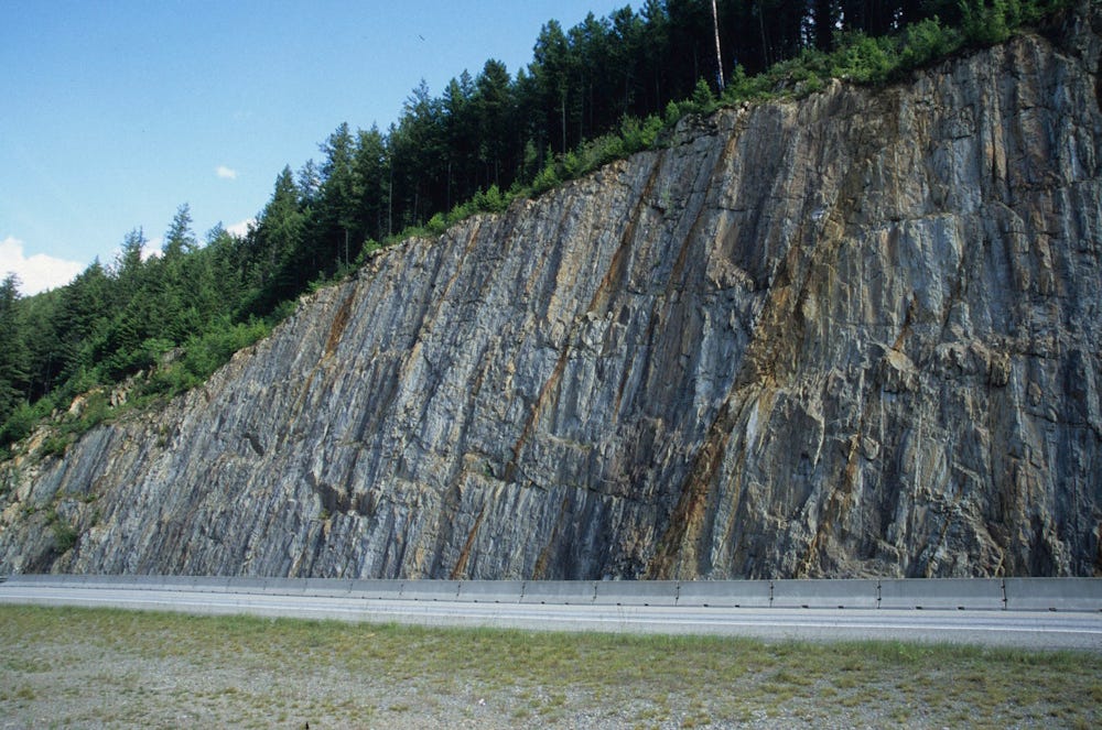
These rocks today stand nearly vertically along Highway 2, tilted by the collisions that compressed northwestern Montana during the Laramide-Sevier Orogeny about 70 to 50 million years ago, more than a billion years after the sediments were laid down and turned to rock.
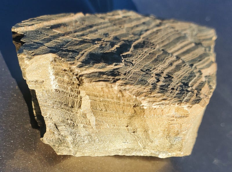
I collected the rock in the photo during the Tobacco Root Geological Society field conference in 2006. What appear to be bends and breaks in the thin beds in the top photo are really just the result of the surface of the rock cutting obliquely and irregularly across the beds, which are actually quite uniform and flat in a cross-section perpendicular to them, as you can see in the side view above. There is at least one probable mud crack in the lower part of the top photo.
I posted about stromatolite in my non-erudite way a week ago https://open.substack.com/pub/aboutmountains/p/bacterial-sludge-stromatolites?r=1fe93o&utm_campaign=post&utm_medium=web&showWelcomeOnShare=false
As usual my brain has trouble making sense of these unfathomable time scales.