I think geologists are attracted to the unusual (I am, anyway), and spotted rocks are at least relatively unusual.
Brown spots
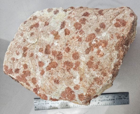
The spotted rock in the top photo is the Cambrian Flathead Sandstone, deposited about 520 million years ago, marking the earliest deposits of the Paleozoic Era as the sea transgressed across North America (and other continents). This piece is from an outcrop near Newlan Creek Reservoir north of White Sulphur Springs, Montana USA.
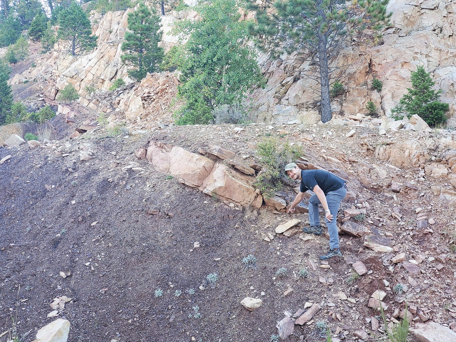
At this location the Flathead lies with angular unconformity on the purple argillite and mudstones of the Spokane Formation, part of the Precambrian Belt Supergroup rocks deposited about 1.4 billion years ago. So the surface between them that Joel is pointing to in the photo above represents a gap of around 900 million years where material was either not deposited, or was eroded, or (as is certainly the case here) both. That’s what an unconformity is, a gap in the rock record.
Because the underlying Spokane Formation rocks are at an angle to the overlying Flathead, we know the older rocks were tilted and eroded before the Flathead was deposited over that surface.
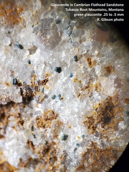
I picked up the rock for its excellent display of brown spots. These are not inclusions of extraneous things in the rock, but rather are concentrations of iron oxides and hydroxides (“limonite,” which is a mixture of things like goethite and hematite) in the pores between the sand grains. The Flathead sandstone is typically brown to pink because of its iron oxide cement, but how these spots form is a little less certain. One idea is that the iron came out of glauconite, a potassium-iron-magnesium silicate, which is usually inferred to represent fecal matter from invertebrates in the Flathead sand setting, mostly trilobites.
But tiny glauconite pellets (usually less than a millimeter) are usually relatively uniformly scattered through the sandstone, not in clusters, so the iron oxide probably was concentrated in the spots by some process of water percolating through the rock even if it might have originated in glauconite. Variations in the porosity and permeability of the sandstone might have focused the iron-rich water into selected locations where the iron oxide precipitated out, producing the spots. Such a process would not require the iron to come from glauconite pellets, since it could have been dissolved from the general iron oxide cement that permeates the sand.
In any case, spots like this are quite common in the Flathead Sandstone, but this is a pretty nice example.
Round spots
The Meagher formation (named for Meagher County, Montana, which was named for Thomas Meagher, and is pronounced MAR, at least by most geologists; purists may want to be more Irish and say ma-hur, or something else) is a Middle Cambrian limestone deposited about 500-510 million years ago on what was a continental shelf, tectonically passive like the US East Coast today. Western Montana at that time was not far above the equator. The map below showing the relationships of lands and seas during Cambrian time (paleogeography) is modified from Harper (2019, Journal of the Geological Society 176 (6): 1023–1037; via Wikipedia, CC-by-SA). North America (labeled Laurentia on the map) was oriented with today’s north-south axis turned to east-west during the Cambrian, so western Montana (the red bar) was a near-shore position facing north.
During the Cambrian, much of North America saw a progressive transgression of the sea over millions of years, meaning that marine waters encroached further and further over the continent, so that any given spot at or near the shoreline became deeper and deeper in the water. One consequence of this is changing sediment types in any particular position, from beach sands (the Flathead Formation, the oldest Cambrian unit in western Montana) to silts and muds in deeper water (which form the Wolsey Shale, younger than and on top of the Flathead), and then to limestones in even deeper water (the Meagher formation overlies the Wolsey).
But it is not as simple as the transgression of the sea. You can get limestone in shallow water, and there is evidence within the Meagher formation that some of it did indeed form in quite shallow water, so we might visualize something like the carbonate shelf off western Florida today. The sea in which the Meagher limestone formed contained trilobites (probably the most abundant macroscopic life at the time), and in a zone about the middle of the Meagher formation is a section that contains cross-bedded oolites that you see in my photo.
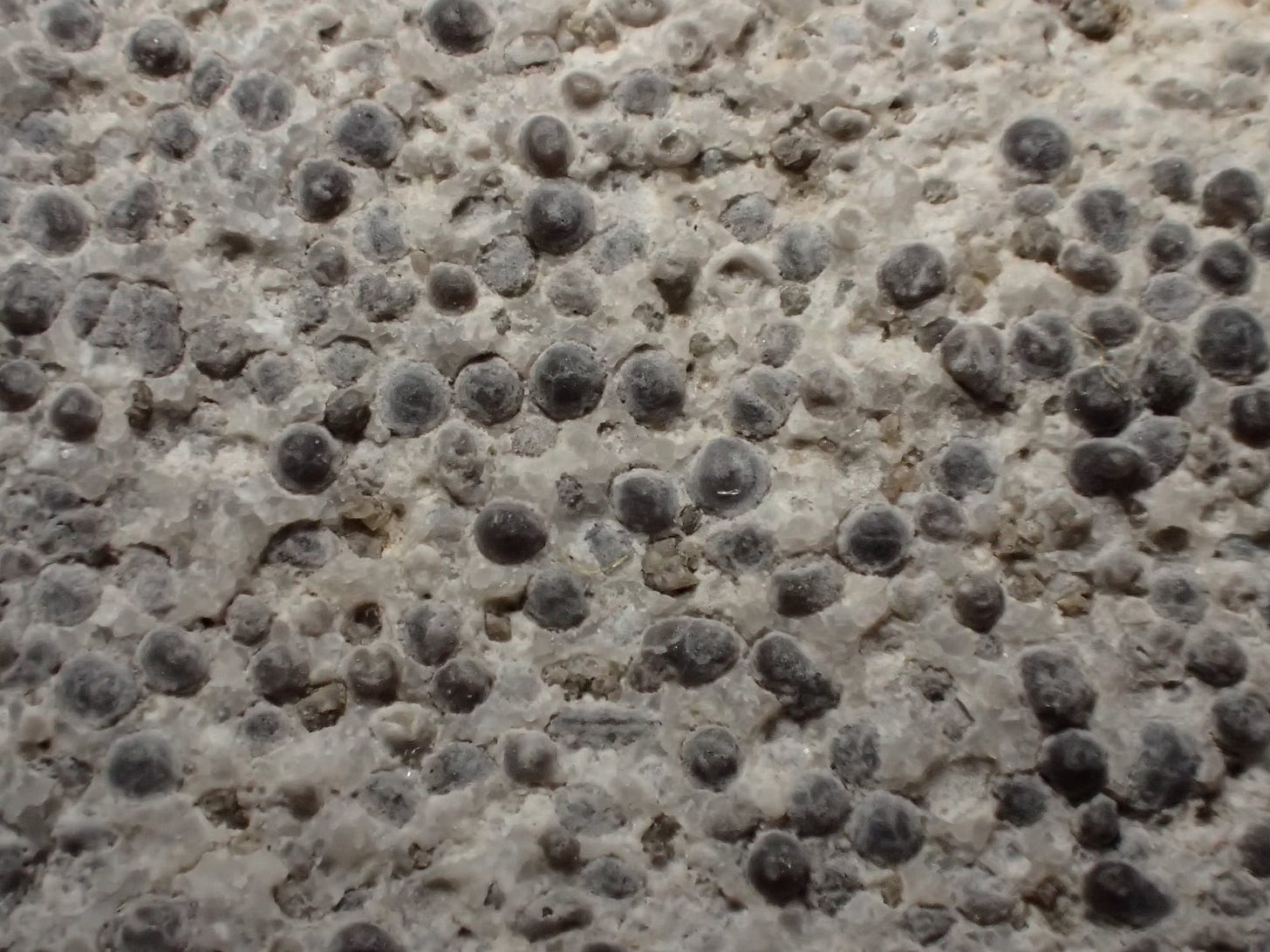
Ooids are small (usually less than 2 mm) usually almost spherical balls of limestone cemented into a limestone rock called oolite (the word is from Greek words meaning “egg stone”). Ooids often have a concentric structure centered on something that serves as a nucleus – a sand grain or a fossil fragment, for example. Oolites are usually interpreted to represent water supersaturated in calcium carbonate (calcite, the main constituent of limestone) in an energetic environment where the calcite is deposited on the nucleus and is more or less continuously rolled around, in a current or a swash zone along a shoreline. So they must form in shallow water, above wave base at least.

Cross-beds are layers of rock that form at noticeable angles to the usual near horizontal bedding that sediments settle into. They represent bedding formed in a flowing medium – wind, currents, waves. Ripples and sand dunes are common bed forms where cross-beds develop. They are probably more common in granular sediment like sand, but they can form in limestone if the material is in grains. In the middle Meagher limestone, the oolite grains were swashed around by the water in which they were deposited to the extent that they formed small irregular cross-bed forms on the water bottom – little submarine dunes, or perhaps complex piles of ripples (but these features can reach a few tens of centimeters, and that’s larger than we’d expect ripples to be). That produced the cross-bedded oolite beds in my photo. It’s reasonable to interpret this zone as a shoal, a carbonate bank, definitely in quite shallow water and perhaps not far from the shore.
The specimen is from the outcrop of the Meagher formation along the South Boulder River in the northern Tobacco Root Mountains. The cross-bedding is significantly more evident in outcrop than in this piece, but I’ve tried to show the angular relationships of the beds in the right-hand photo above. The close-up at the top of this section shows the ooids, which are mostly just a bit smaller than 2 mm across. Cat. No. 1464.
Dark spots
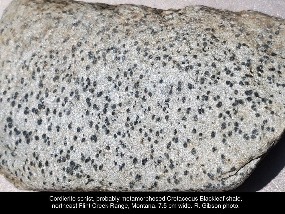
Until 2020, I’d never knowingly seen cordierite “in the wild” nor collected it. This rock, spotted somewhat like a cheetah, is cordierite hornfels or schist or phyllite, where the dark spots are cordierite embedded in a micaceous matrix. The grains are throughout the rock, not just spots on the surface.
Cordierite is a low-pressure (less than 2 kilobars), medium- to high-temperature (300 to 800 ºC) metamorphic mineral that often forms in places where argillaceous (clayey, shaly) sedimentary rocks are “cooked” by contact with igneous intrusions. In this case, the original sedimentary rock was probably a shale in the Cretaceous strata of the northern Flint Creek Range, Montana, either the Kootenai formation or more likely a formation within the Colorado Group, perhaps the Blackleaf Shale. The igneous intrusion was probably a thick sill (“sill” means it was injected parallel to the sedimentary beds rather than cutting across them, which would be called a dike) of more or less andesitic composition (intermediate between granite and basalt) that was emplaced in and metamorphosed those shaly rocks around 75 to 50 million years ago.
Cordierite is a magnesium-iron aluminosilicate named for French mineralogist Pierre Louis Antoine Cordier (1777-1861) who first studied it. It’s actually fairly common worldwide. Some of it in the rock in my photo might be somewhat altered to pinite, which is not a mineral but a rock name for a mixture of muscovite mica and clay minerals, but I think generally the cordierite is largely unaltered. In some other specimens, what I think (with significant reservations; it may be actinolite-tremolite) may be more cordierite shows radial twinning that appears to make bow-tie-like sheafs of cordierite.
“Schist” implies a planar or at least semi-planar fabric (called foliation) in the rock, imparted by parallel or sub-parallel plates of mica. This rock has that, but it’s somewhat crudely developed as we’d expect in a low-pressure situation, or at least one without very strong directed stress. Strong directed stress creates the layering typical of familiar metamorphic rocks like coarser schists and gneisses. Phyllite is a micaceous rock with minerals usually much finer grained than schist, but with enough mica to produce a sheen. The complete absence of such directed stress in a high-temperature metamorphic setting would result in an unfoliated rock, generally called hornfels (German for “horn stone” because it was commonly tough and resistant and stuck out like horns). Hornfels is closely associated with this cordierite rock, and here in the Flint Creeks some hornfels contains both andalusite and sillimanite which are common associates of cordierite in these rocks, although conditions of formation dictate that sillimanite and andalusite themselves would be unlikely to occur together in the same rock.
To produce schist or phyllite rather than hornfels, it might be that some zones were indeed subject to greater directed stress, or there may have been more water present to generate mica that tends to align to make a schistose texture, or the original rock (the protolith) might have had a somewhat different composition, or some combination of all of those. The planar fabric might also be affected by tectonic events such as faulting and folding which have certainly happened in this area of the Flint Creek Range. This material is so fine grained it might be more reasonable to call it cordierite phyllite rather than schist, but I’d probably call it a phyllite rather than hornfels, too. It’s all somewhat subjective.
The rock is somewhat rounded and 7.5 cm long. It was a cobble in a gravel on Ballard Hill in the Flint Creek Range of southwest Montana USA. The nature of that gravel is problematic and arguable: It is older than glacial till according to Joel Dietrich and Larry Smith of Montana Tech who worked in the area, but its relationship to other Tertiary gravels is difficult to discern. This rock contributes to multiple stories.
Variable spots
This one is another cordierite rock. Based on x-ray diffraction by Chris Gammons the white spots are a mixture of cordierite, quartz, and albite (feldspar) in about equal proportions. This is expectable in a hornfels (a contact metamorphosed rock, mostly heated without much pressure) which is what this appears to be: metamorphosed Cretaceous Blackleaf formation (shales, mud rocks, sandstones) as mapped by the Montana Bureau of Mines and Geology (Scarberry and others, 2019, Butte North Quad, Open-File Report 715). This one has no discernable fabric of mica, neither fine nor coarse, so I don’t think there’s any argument about it being a phyllite or schist, like the previous specimen. This is just normal hornfels, in which the spots of cordierite-quartz-albite grew when the rock was heated.
Big blue-gray-greenish spots
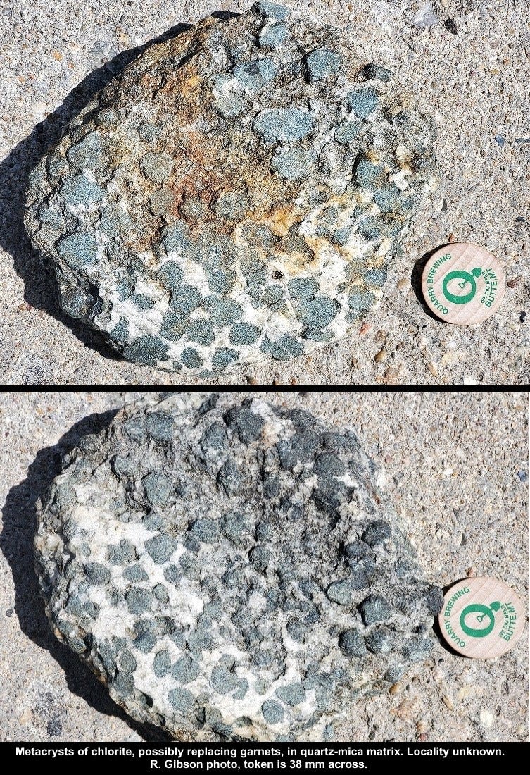
I’ve been hauling this rock around for decades. I’m 90% sure I got it in 1967 when the Flint (Michigan) Junior College geology museum culled a lot of stuff, discarding things they had no information about. So there’s a slight possibility that it’s from Michigan or Canada, but they had plenty of other things – it wasn’t a bad little museum for a junior college.
At 18 cm across (the token in the photos is not quite 4 cm in diameter) this cobble is well rounded (with some ragged broken areas on the back, where you can see the knobby garnet-like nature of the dark things better), so it undoubtedly came from some coarse material in a river or beach or possibly glacial drift or till. The white stuff is quartz, and there’s bronze-weathering mica with it. The blue-gray rounded blobs are roughly equant clasts (more correctly, metacrysts, crystals formed by recrystallization and growth under metamorphic conditions) that are mostly some soft blue-green material, most likely some mineral in the chlorite group, supporting tiny grains that are likely quartz but might be bits of garnet.
I think the blue-gray blobs are (or were) garnets that are largely altered to chlorite, and I don’t much doubt that the rock is a metamorphic rock. Garnets this big aren’t incredibly unusual, but if these really were garnets, it would have been quite a spectacular rock before they altered to chlorite. There’s a famous locality for big garnets at Gore Mountain in the Adirondacks of New York, where garnets up to 2 feet across are known. I think the matrix there is usually more mafic (iron-magnesium rich) material and ought not to be the quartz-mica that we see here, but I’m not any kind of expert on those rocks.
This rock probably tells two metamorphic stories: One in which the big original garnets grew, then a second time when the garnets altered to chlorite. That latter event could have been retrograde metamorphism, when the high-temperature garnets were replaced by low-temperature chlorite. It might represent cooling, or a second heating but to a temperature lower than that which produced the garnets. Or it might just be simple alteration without significant metamorphism. Some of this rock’s stories remain unclear.
If others have ideas for either the nature/history/occurrence of the rock, or of a locality that it might have come from, please chime in.





Interesting to see your post on the Meagher formation. I, as you know, just had a brief FB conversation with Rob Thomas on his FB page regarding LaHood formation rocks with my focus on the northern Tobacco Root mountains. Although I was mostly commenting on the LaHood rocks I did slip in that I had been working on Meagher formation mineralized rocks at the time. Because we were focusing on possible mineralized zones I was unaware of any oolitic zones in the Meagher and that is pretty cool and I'm sorry I missed them.
Kind of off topic but I got into a disputed conversation (online of course) with someone that wanted to dispute that ooids were formed by direct precipitation of calcite from seawater. He continued to pronounce that that was impossible because waters were "acidic" (or some other crazy reason which I have purged from memory to protect my sanity). He obviously ignored that we were discussing seawater and refused to believe that you could see this process happening in the Caribbean ocean and the white "sands" on Caribbean beaches were mostly ooids. Well I learned my lesson (mostly) and limit my discussions with sane people.
Learned something new. The "swash zone" of a shoreline. A few years ago in summer on Lake Michigan, I snorkeled along the edge of the lake in about 1 foot of water, looking for 'cool rocks.'. Hoping to find something that might have micros inside. I noticed that where the waves crashed, the rocks were clean and fresh looking, but in a mere 2' of water, they were mossy and obscured by fibrous growths growing on them, aw-- the waves scour only a very narrow band of shoreline then.
I don't remember if I found much that day, but I has beach goers wondering what in hades I was doing, lol