
Tennessee
Three Tectonic Provinces

Life in the USA is not normal. It feels pointless and trivial to be talking about small looks at the fascinating natural world when the country is being dismantled. But these posts will continue, as a statement of resistance. I hope you continue to enjoy and learn from them. Stand Up For Science!
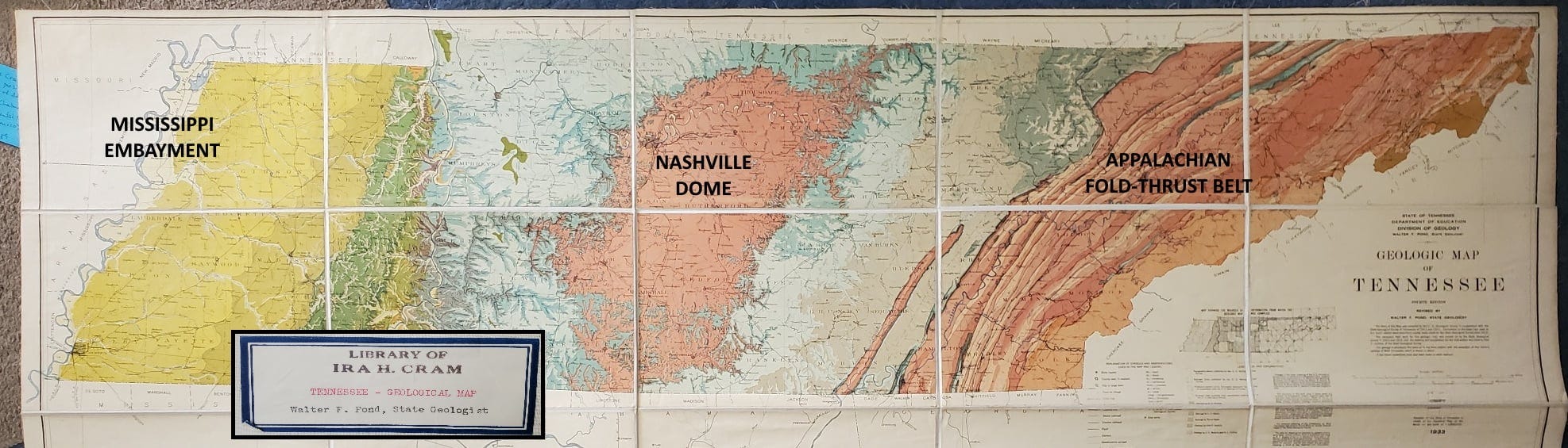
The geologic map of Tennessee shows three dominant tectonic features.
At far left, along the Mississippi River, the yellow and green shades represent rocks of Cenozoic and Cretaceous age, about 90 million years to present. They occupy the Mississippi Embayment, a deep crustal feature whose origin was in a faulted rift at least as long ago as the Cambrian, 520 or so million years ago. That rift “tried” to break the North American continent apart, but it failed. But it is a persistent weak zone, constraining the position of the Mississippi River and producing the famous earthquakes in the New Madrid zone that continue shaking the region today. In the far northwest corner of Tennessee on this map you may make out Reelfoot Lake, a lake that formed as a consequence of the huge earthquakes in the New Madrid area in 1811-1812. For a narrative of the events surrounding those earthquakes, you might enjoy When The Mississippi Ran Backwards.
Central Tennessee is dominated by a roughly oval salmon-colored zone on this map surrounded by light blue colors. That’s the Nashville Dome, a broad uplift with the oldest rocks (Ordovician, 450-480 million years) in the center, flanked by younger sedimentary rocks (Mississippian age, 330 million years). The Nashville Dome is really just a continuation of the Cincinnati Arch from the north, and the whole thing is a broad warp in the continental crust that probably had its origin in tectonic collisions hundreds of kilometers to the east, in the Taconic Orogeny beginning about 470 million years ago and continuing for several million years.
Eastern Tennessee, at right, is a complex zone of sub-parallel belts that are expressions of the Appalachian-Alleghenian Orogeny, the culmination of the assembly of Pangea. The part of Gondwana that is now in West Africa (Senegal, Mauritania, Western Sahara) collided with what is now the Carolinas and Virginia. The push and squeeze affected the rocks as far west as eastern Tennessee, and the map shows a series of linear faults that juxtapose several discrete tectonic zones including the Blue Ridge, Valley and Ridge Province, and the Appalachian Plateau. They represent different geological bodies and sets of structures, things like island arcs and small elongate continental bodies as well as sedimentary rock piles developed along and within them, that amalgamated though squeezing (which produced thrust faults and folds) against North America in what is now eastern Tennessee about 320 million years ago.
The name Tennessee is probably from the name of a Cherokee village, Tanasi, whose name origin is uncertain, but may be from the Yuchi word Tana-tsee-dgee, meaning "brother-waters-place" or "where-the-waters-meet" (from Wikipedia).

My copy of the 5-foot-long map was published in 1933 and is mounted on linen. It was in the library of Ira H. Cram (1919-1989), President of the American Association of Petroleum Geologists (1944) and Chairman of the Continental Oil Company (Conoco) from 1959-1966. He had joined Continental in 1949. I acquired the map in the mid-1990s for the outrageous cost of ten cents.
Awesome. I wish that we would have had this image when we did our end-to-end tour of Tennessee's Civil War battle fields and cavalry skirmish sites a few years back.
Thanks
A piece of art with a log of geology.
I’m jealous of your map .