The Bakken
Ups and Downs
This post is updated and modified from my 2014 History of the Earth podcast episode about the Bakken.
When I started the Bakken Formation page on Wikipedia in 2007, oil production from it had just begun to take off. In 2007 North Dakota was producing about 120,000 barrels a day, but by 2014 it was ten times that, at 1,200,000 barrels a day, making it the second largest oil producing state in the U.S., after Texas. Bakken oil production appears to have peaked in 2020 at about 1.5 million barrels per day.
Montana’s oil production peaked in 2006 at about 102,000 barrels per day and declined through most of the Bakken boom (with some ups and downs) to about 62,000 barrels a day in 2024. Montana shares the Williston Basin, where the Bakken is found, with North Dakota – so why didn’t Montana share the Bakken boom?
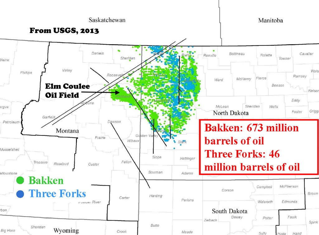
The boom actually did pretty much start in Montana, with the discovery of Elm Coulee Field in Richland County in 2000. Much of Montana’s oil came from Elm Coulee (I started that Wikipedia page too 😊 ), but it began to decline about 2007; the oil fields in the Bakken tend to have relatively short lives because of the geology.
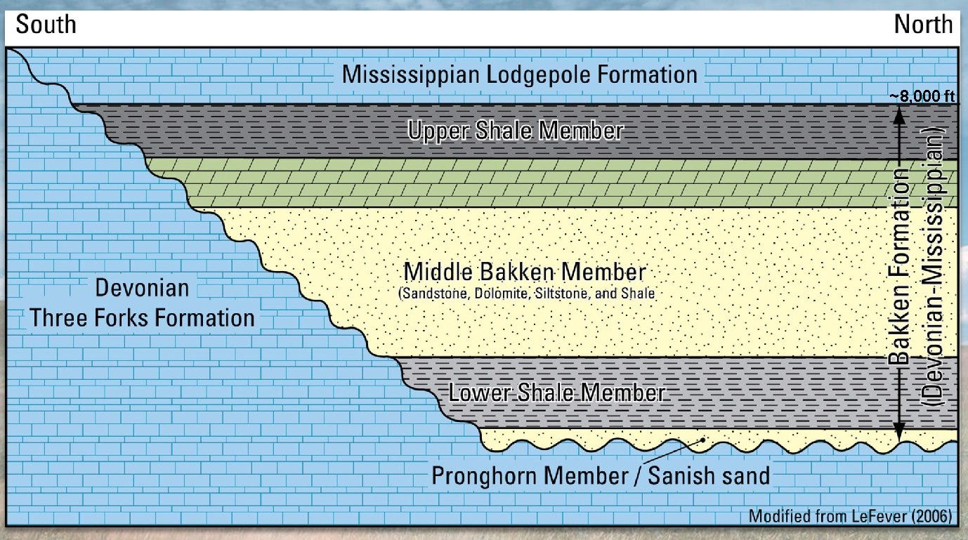
The Bakken is Late Devonian to Early Mississippian in age, about 350 to 370 million years old. It is a complex formation, with the part related to oil broken into three units: two black shales that sandwich between them a package of mixed rocks including dolomite and siltstone. The black shales are rich in organic material, in places more than 8% total organic carbon (good Saudi Arabian oil source rocks are 4%-5%), which makes them outstanding oil source rocks. The dolomite, calcium-magnesium carbonate, between them is soluble like limestone, and has a lot of porosity (averaging about 5% of the rock), making it an excellent oil reservoir rock.
The problem is that the permeability of the dolomite, the interconnectedness of the pore spaces, is really low, preventing oil from flowing from one pore to another and into an oil well. Consequently, producing oil in the Bakken has required special technologies. A simple vertical well could (and many did, in the 1950s and 1960s) go right through the Bakken dolomite reservoir and produce essentially zero oil, because in the 90 feet of reservoir, the well was exposed to very little actual oil that could flow into it. Bakken production comes from wells that are drilled 8,000-10,000 feet down, then steered to turn 90 degrees to pass approximately horizontally through the dolomite reservoir, which the drill may go through another 5,000 or 10,000 feet to expose the hole to as much oil-bearing rock as possible. Then the rock along the hole is fractured by explosions or injecting material (fracking) to interconnect the pore spaces so oil can actually flow into the well bore.
Horizontal or directional drilling is challenging and expensive (around $6-$7 million per well, compared to $500,000 to $1 million for a similar conventional well) and requires detailed knowledge of the rocks to try to hit the ‘sweet spots’ where the oil is best. The Bakken Formation is by no means uniform across the hundreds of miles of its subsurface extent, and you can imagine that hitting a 90-foot-thick zone 10,000 feet down, and then turning and staying within it for two miles, is a difficult thing, although modern down-hole navigation can hit even smaller targets.
Because Bakken wells are expensive, when the price of oil goes down, new drilling in the Bakken also typically goes down. It depends of course on how much oil is found, but generally the break-even price of oil for a new well in the Bakken is at least $45 a barrel and for some, as much as $80 per barrel or more. For some scenarios for some wells, the price of oil needs to be around $110 a barrel for the well to break even financially. The price of oil in early 2008 was about $127 a barrel (not adjusted for inflation), perfect for the developing Bakken boom.

The three thin layers in the Bakken, the two black shales (each about 50-60 feet thick) and the middle dolomite (90 feet), represent relatively rapid changes in depositional conditions. The black shales probably resulted from generally deep-sea deposition of very fine-grained material under anoxic conditions. The lack of oxygen (anoxia) is why so much organic material was preserved; it was neither oxidized nor washed away by good oceanic circulation. The dolomite probably represents a coastal carbonate bank something like the west coast of Florida today. Eastern Montana and North Dakota were near but slightly south of the equator at the time the Bakken was deposited.
The most likely explanation for the relatively rapid changes in sea level that made for the striking changes in rock types is the glaciation going on at the same time. Although Montana was near the equator, much of the continental land mass of the world was near the south pole, and multiple glacial events took place that made for significant world-wide changes in sea level.
The anoxic periods that resulted in the Bakken black shales are found around the world, and are part of an end-Devonian extinction event which is one of the “big five” extinctions in earth history, with something like 75% of species dying off. The glaciation alone is not likely to be the sole cause of the extinction event, and the glaciation itself is not fully understood. It’s possible that the rise of the first forests and proliferation of land plants may have reduced carbon dioxide in the atmosphere enough to promote global cooling, but whatever caused it, the huge die-off means that late Devonian rocks contain some of the best oil source rocks on earth, including the Bakken.
So, ultimately, Montana did not follow North Dakota in the Bakken boom in part because Montana’s one big Bakken field, Elm Coulee, was found early and had already been largely depleted, but it was more because all the special geologic conditions that make the Bakken a great oil source and reservoir rock were better developed in the formation in North Dakota than in Montana.
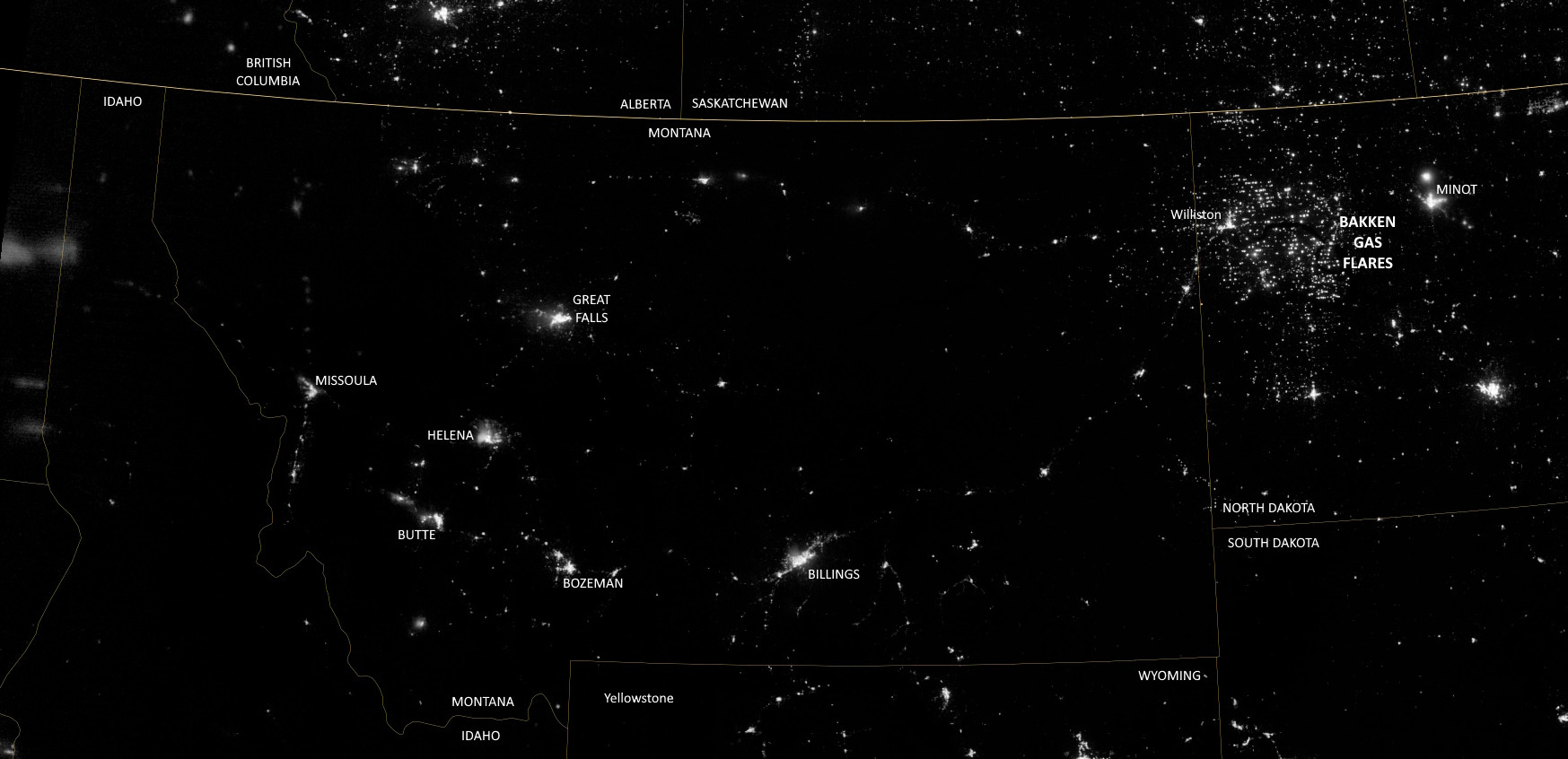
The Bakken also generates a lot of natural gas, and the amount recovered has been increasing over time, but in 2012 nearly a third of it was flared (burned off) because of an inadequate gas pipeline network and lack of nearby processing facilities. The flares are evident in the night image above. When that image was made, the Bakken produced about 500 million cubic feet of natural gas per day, but by 2021 that had increased to nearly three billion cubic feet per day and only about 8% was being flared off. For perspective, today the US produces about 125 billion cubic feet per day, and the leading producing states in order are Texas, Pennsylvania, Louisiana, and Alaska.
The rock unit was named for a son of Norwegian immigrants, Henry O. Bakken (1901–1982), a farmer in Tioga, North Dakota. He owned the land where the formation was initially discovered in the subsurface.


Another great article Richard, we were so lucky to have had so much tropical beach front property in our geologic history that has helped drive our energy independence and growth as a nation. My parents owned a cabin about 30 miles south of Titusville, PA where Drake drilled the first oil well in the world. Driving through towns like Oil City always made me wonder as a kid why it was called that. Very neat paleogeography maps and explanation that helps us understand the underlying conditions that helped create the oil reservoirs. Thank you.
The Sappington unit is in some places mappable as a formation, I think. It occurs at the Three Forks/Lodgepole contact so it is pretty much the equivalent of the Bakken. UMontana has a group studying the Sappington because of this. When we assisted Ray Gutschick with his Sappington project we found it to be a complex though thin package consisting of sltstones and limestones. A remarkable characteristic was the presence of brachiopod- and snail-cored oncolites often with worm tubes and arenaceous forams. Fossil sponges were also present. When we digested them in acetic acid the smell of petroleum was very strong. Joaquin Rodriguez of Hunter College, CUNY studied the brachs with Ray. See: https://www.kgs.ku.edu/Publications/Bulletins/169/Gutschick/index.html for images of these oncolites as well as a look at Ray's beautiful stratigraphic descriptions and figures.