My post today is an interpretation of aeromagnetic data, one of the remote sensing tools geoscientists use. In places like eastern Colorado, much of Nebraska and Kansas and neighboring areas in the Great Plains of the USA, thick layers of sedimentary rocks obscure the deep, older Precambrian rocks, what we call the ‘basement.’ Short of drilling expensive wells, remote sensing data like aeromagnetics are among the most useful ways of discovering information about the ancient geological history of this area.
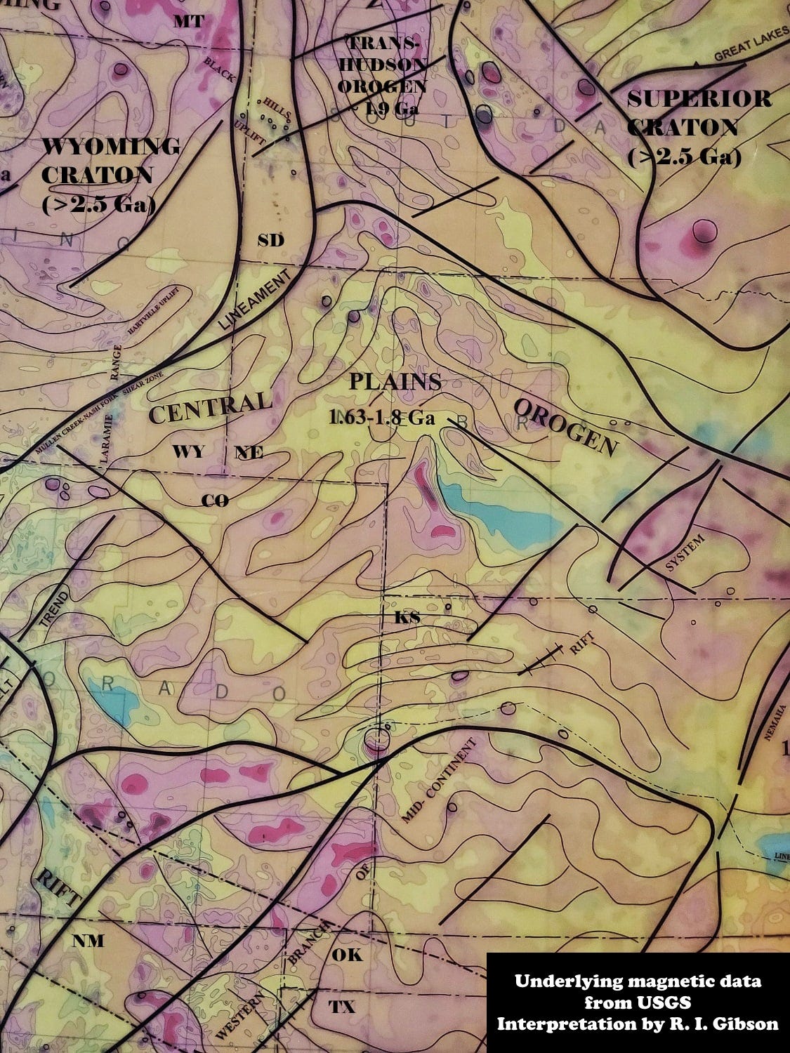
The magnetic map above shows a roughly arcuate suite of magnetic anomalies, alternating somewhat elongate highs and lows that basically reflect the lithology, the rock types, in the Precambrian basement rocks. Magnetic highs have more magnetite, magnetic lows have less, and that is a first-pass statement of what kinds of rocks are present and how they are distributed.
The curvilinear geometry is typical of a mountain belt, where elongate zones of various nature were amalgamated with what was the southern edge of North America about 1,690,000,000 (1.69 billion) years ago (on the map, Ga means “giga annum,” or billion [one thousand million] years). This orogeny (mountain building event) is called the Central Plains Orogeny and it is thought to represent a complex bunch of linear and curved island arcs and other terranes that collided with North America. The alternating magnetic anomalies represent things like piles of volcanic rocks, the granite cores of the volcanic or small continental islands, possible slices of oceanic crust, and the sediments derived from them all as the island arcs impinged on North America – and all are metamorphosed by the intense pressures and heat of the collisions.
My interpretation here (my lines, overlain on the color magnetic map from the USGS) shows how the Central Plains Orogen truncates the Trans-Hudson Orogen, a zone of strong north-south magnetic anomalies between the old Wyoming and Superior Cratons in western North and South Dakota (it continues a long way up into Canada, to the north of Hudson Bay, whence its name Trans-Hudson). The Trans-Hudson represents the collision and amalgamation of the smaller Wyoming Craton with the older central Superior Craton about 1.8 to 1.95 billion years ago, and other collisions in Canada.
Because the Central Plains Orogen cuts across the Trans-Hudson, it must be younger, and despite the dates on my regional interpretation map (which I made in 1993), the Central Plains Orogen is now dated fairly closely to about 1.68-1.70 billion years ago (Hill, 2006, Ph.D. dissertation, U. of Missouri) using information from a few deep wells whose basement rocks have been dated. Some aspects of the collisions are probably somewhat older or younger than those dates, since the whole “event” took a few tens of millions of years.
1.65 billion years ago there would have been a fairly significant mountain range in what is now western Nebraska. Probably not Himalayan in style, because that’s the result of two strong masses – continents – colliding with each other. A better analog for the Central Plains mountains would probably be something like today’s Kamchatka Peninsula, or maybe Taiwan and the Philippines, where an amalgam of volcanic island arcs, oceanic crust, sediment piles, and possible small continental blocks are impinging on eastern Asia. For more information, see for example, Whitmeyer and Karlstrom, 2007, Tectonic model for the Proterozoic growth of North America: Geosphere 3 (4): 220–259.
While it seems likely that Kansas and Nebraska may have been the central focus of the Central Plains Orogeny, it’s also likely that some rocks were accreted (amalgamated) to North America at this time as far east as Iowa and Wisconsin, and as far to the southwest as most of Colorado, northern New Mexico, and parts of Arizona. The action to the southwest is usually called the Yavapai Orogeny, and it may be slightly older than the Central Plains portion of what was a broad, far-reaching and long-lasting tectonic event that made North America quite a lot larger than it had been previously.
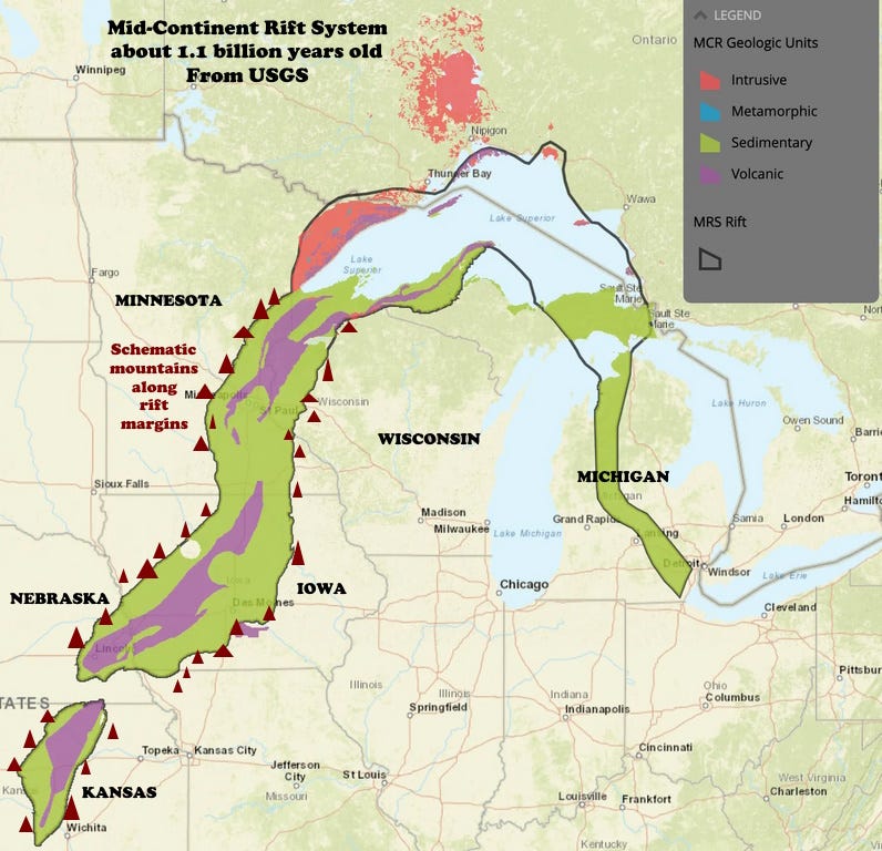
Whatever the height of the mountains in Nebraska and Kansas and adjacent areas, they began to erode as soon as they were uplifted, and after about 500 million years of relative peace, the region was probably eroded down to a relatively flat or perhaps undulating series of plains and low hills – like the Appalachians might be 200 million years into the future. Then, about 1.2 billion years ago, instead of compression and collision, the area began to extend, to be pulled apart, forming long linear fault-bounded troughs. The break cut right across (almost perpendicularly) the older Central Plains mountain belt.
North America was trying to split in two, much like the East African Rift is breaking the African Continent apart today. The troughs held lakes – like the great lakes of East Africa, including Tanganyika, Malawi, Turkana, and others.
But the lakes in the North American Mid-Continent Rift System of 1.1 to 1.2 billion years ago were unlike today’s African lakes in that they supported only microscopic life – algae and bacteria, albeit in huge volumes in places. Like the African rift system, the Mid-Continent System was created by huge fault breaks that let magma rise up and in places partly fill the downdropped troughs in and near the lakes.
Those troughs would have had high mountainous escarpments on their flanks, in what are now eastern Kansas, far southeastern Nebraska, and across Iowa into Minnesota. But give erosion another 600 or so million years and things were pretty flat again about 510 million years ago, when the Cambrian Flathead, Deadwood, LaMotte, Bonneterre, Mt. Simon, and equivalent sandstones were deposited in a vast sheet encroaching over the continent from Montana east to New York. The Great Plains have had some gentle ups and downs since then, but no major mountain-building has happened there for a very long time.
There have been notable mountains in what are now Nebraska and Kansas at least twice in the past 2 billion years – all eroded long ago.


What a neat article Richard. Thanks for sharing this. I haven't learned much about these aeromagnetic maps although I'm aware of them. Got my masters at KU in Geography and GIS and I would sometimes - for headspace - drive out to the flint hills and take a nap in the tall grass prairie preserve. It was very still and quite in the fall, you wouldn't catch chiggers, and I could daydream about what I wanted to do when I grew up, back against earth, and watching cumulus float by. Makes me think what it was like circa 2 billion years ago when this was actual coastline! and exotic terranes were lining up ready to join a more stable craton. All that history was below my back as I lay on those Flint Hills as you point out the evidence of these maps. Such cool stuff, I'm glad I stumbled upon your substack page via your FB "History of the Earth" blog where you did daily posts for a year describing all of geologic history on Earth. -That should be enshrined, what an awesome series.. I'm still deep diving that. Have a good day sir!
Interesting visuals of what is under the prairies and also the various segments of Central and Western North America. With an interest in Assembling Colorado, as presented by Abbot & Cook and others, I have been curious about why the Mid-continent Rift System bends at Lake Superior into a U-shape and heads down through lower Michigan. What forces may have been involved. I would expect a mostly linear trend like Africa or Nevada.
Thanks