The Texas Panhandle is flat. No news there. But beneath that flat surface is a remarkable set of geological stories.
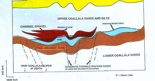
This cross-section above is from a project I worked on to help characterize the contaminated perched aquifer at the Pantex Plant, where most of the United States’ nuclear bombs were assembled.
In the cross-section, the “Fine-Grained Zone” is the impermeable aquitard (a zone that retards water flow) that holds the ponded, contaminated perched aquifer some hundreds of feet above the main unconfined Ogallala Aquifer. Its complex geometry is a result of salt tectonics, the dissolution and subsidence of much older (Permian) salt hundreds of feet further down.
The salt dissolution in turn results from a huge formerly mountainous uplift that formed about the same time (late Carboniferous into Permian time, generally around 250 million years ago but extending over many tens of millions of years) as the Appalachian Mountains and for related reasons: the collision between the North American continent and Gondwana. In the Appalachians, the part of Gondwana that was colliding is now Africa, and here in Texas (and in the Wichita and Ouachita Mountains of Oklahoma and Arkansas) the part of Gondwana that collided is now in Yucatan, Nicaragua, and northwestern South America. Faulting and other structures related to this mountain uplift broke or stressed the overlying salt beds so they were predisposed to dissolve and collapse in particular zones, and the even later sedimentary deposits follow those collapse zones, at least to some extent.
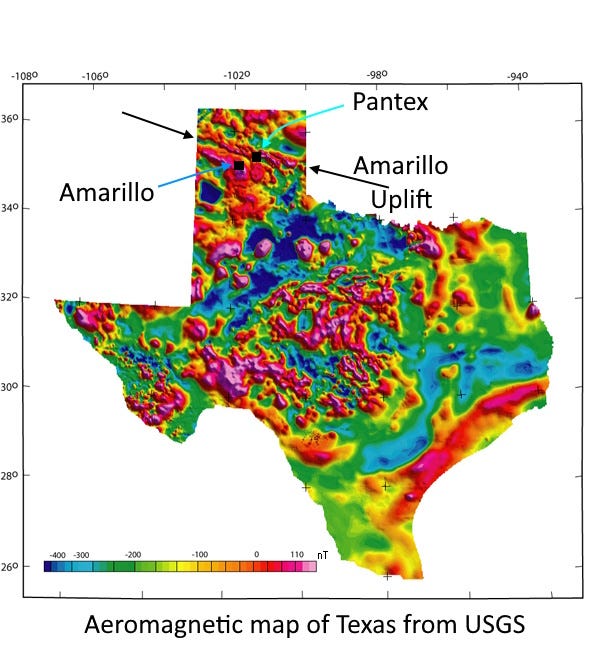
The old mountain uplift here in Texas, called the Amarillo Uplift, has been completely buried beneath later sediments, but it still affects things as young as the Ogallala Aquifer, whose rocks were deposited only a few million years ago. And it is visible in a map of magnetic measurements as the linear zone of high intensity (red) that you see above. The magnetic map reveals far greater complexity in the subsurface than the flat Texas Panhandle suggests.
Note that the figure at the top has a 20X vertical exaggeration. The cross-section is constrained by information from 14 wells including existing well logs and new drilling for this project, so it’s not really overly schematic; we had information from 71 pre-existing wells for the whole project. And yes, the perched water table really does slope; high rates of recharge in very specific locations mean that surface isn’t flat as you might expect a water table to be. The total relief on the water table is about 55 feet over two miles.
I was the well-site geologist for the site characterization project conducted by Argonne National Laboratory. It was a great project intellectually, but it does not break my heart to know that I never again have to spend three cold windy months outside on the Texas Panhandle.
If you’re paying attention, you know I like to share pics of random rocks that tell stories. This one is a cobble of granitic rock from the Texas Panhandle. As a field term, I called the flashy purplish spots lepidolite mica, typical in igneous pegmatites. The problems: there are no outcrops of such rocks anywhere near where this was found, 235 feet down a drill hole at the Pantex Plant near Amarillo, and the package of rocks that included this one, the Ogallala formation, was expected to only contain fine-grained wind-borne sediments, nothing like this big rock which could only have been moved by a pretty strongly flowing river.
The purplish mica I learned to call lepidolite is now considered to be the polylithionite-trilithionite series, or “lithium bearing muscovite,” and apparently most “lepidolite” and lithian muscovite are now construed to have the purple-pink color because of manganese ions rather than lithium. That’s irrelevant to this story.
The bottom line was that this rock must have been carried by a significant river system from outcrops in the Sangre de Cristo mountains of New Mexico, 150 miles west of where the rock was deposited. That unexpected river system had implications for the tectonic history of the region and for the materials in the Ogallala aquifer, which we were trying to understand because there is a portion of it contaminated by decades of waste from the Pantex nuclear facility, where many U.S. atomic bombs were assembled.
We called this the $100,000 rock because the drill string got stuck at about 240 feet down, and before we got the drill out, it had pulled the guts out of the sonic drill rig, costing about $100,000 to fix. This rock was all that was found in the drill pipe, whose bit curled inward from the pressure of the rocks it was trying to cut through, to close off the end of the open pipe, catching this rock inside.
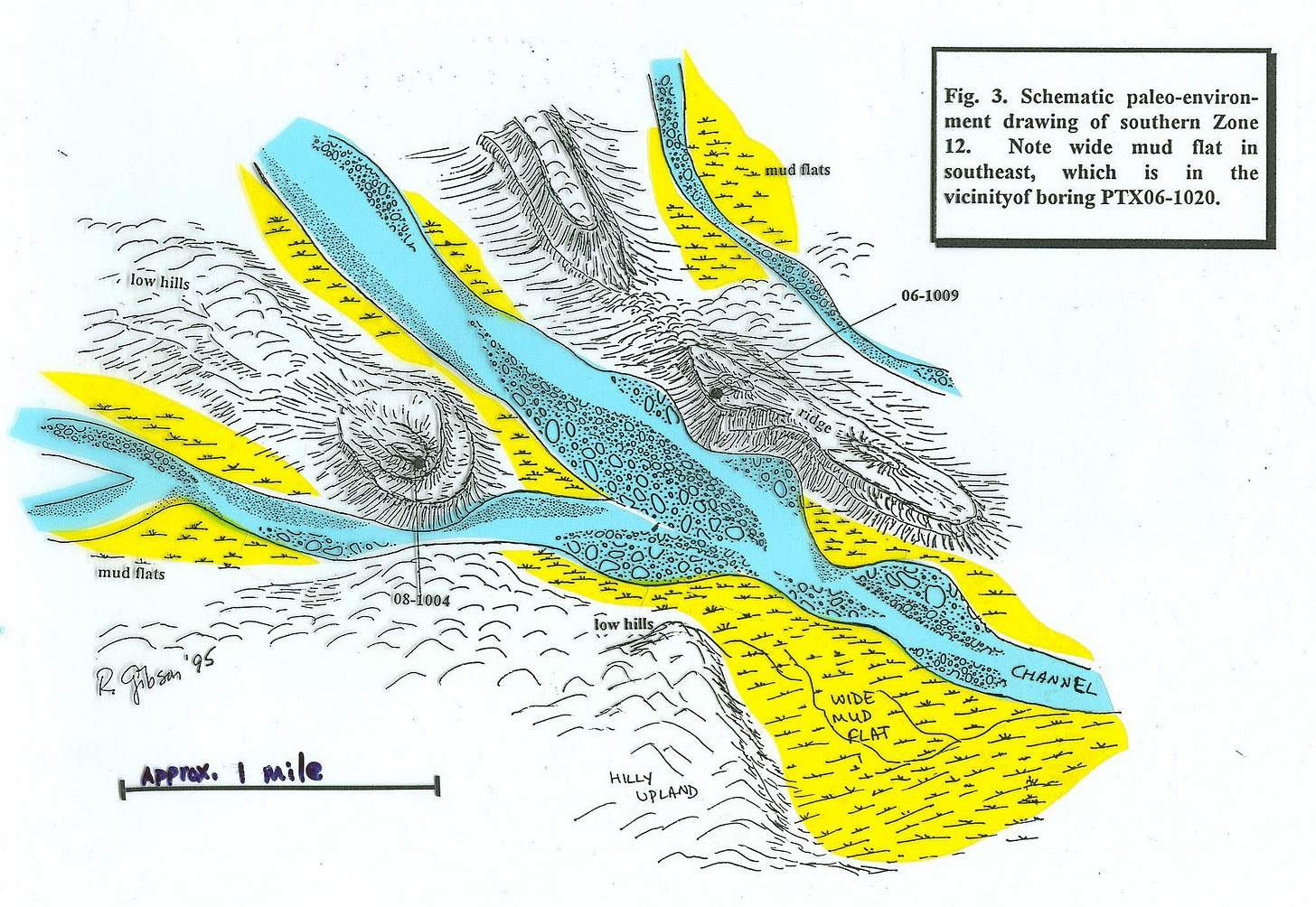
The upshot of the project was an interpretation of the environment of deposition of the Ogallala that was rather different from the conventional model. I inferred a period of tectonic uplift that resulted in the river system that deposited coarse gravels as well as mud flats within the Ogallala formation, forming better aquifers (and better aquitards, units that stop flow) than had been expected from the standard idea of just eolian (wind-borne) sands.
Above is my interpreted map of the surface at the time of the river system, probably 2-3 million years ago, based on the drilling information. (This stuff today is beneath a couple hundred feet of additional sediment making a generally flat surface.) Images are from a talk I gave several years ago at the Montana Bureau of Mines & Geology (and previously to the clients for the project back in 1995).
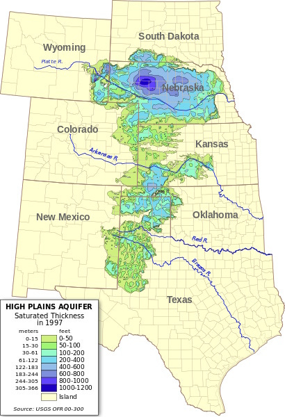
The Ogallala or High Plains Aquifer underlies much of the high plains, from Wyoming and South Dakota to West Texas and New Mexico. It contains about 30% of the groundwater in the U.S., and supplies water for irrigation, industrial uses, and drinking water.
Deposition of the rocks of the Ogallala Formation, which contain the aquifer, began in very late Miocene time, about 6 million years ago, and continued through the Pliocene, until about 2 million years ago when gentle uplift changed the setting from more depositional to more erosional again. The sediments that became the Ogallala were largely sediments that were being stripped off the Rocky Mountains to the west.
The entire package of Ogallala Formation rocks is up to 1,500 feet or so in thickness, and the aquifer itself, in nice porous sands, has a saturated thickness as much as 1,000 feet in places, but it’s mostly 50 to 400 feet of saturation. Most of the Ogallala formation was deposited by rivers, similar to the rivers of the High Plains today, but some parts of it are wind-blown silts and sands as well.
The unit is really highly varied, and contains things like impermeable clay beds that can produce little perched aquifers, like bowls of water sitting above the main unconfined aquifer further down, including the one I worked on at the Pantex Plant.
Given its importance to the region, it’s no surprise that a lot of attention is being paid to the drawdown caused by intense use of the groundwater in the Ogallala. In places, the total drawdown is more than 300 feet – definitely a problem, because recharge to the aquifer, replenishing the water that is removed, comes almost entirely from precipitation, and this region is pretty much arid to semi-arid in terms of climate. Recharge rates are much lower than drawdown rates in places.


In West Texas the draw down on the Olgallala is over 1000 ft and put the Canalope framers out of business