I freely admit that one of my reasons for wanting (and getting) this specimen is its name. But it’s also an unusual, interesting, and beautiful mineral, so there’s that.
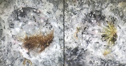
The little brown tufts of tuperssuatsiaite may look like sea urchins hiding in a sea-floor grotto, but it is actually a clay mineral, a member of the palygorskite group. And despite its fragile-looking spikes, it’s a silicate, a hydrous sodium-iron-manganese silicate, Na2(Fe,Mn)3Si8O20(OH)2 · 4H2O. Some are brown and some are greenish; according to MinDat, the change to brown may result from a dehydration-oxidation process.
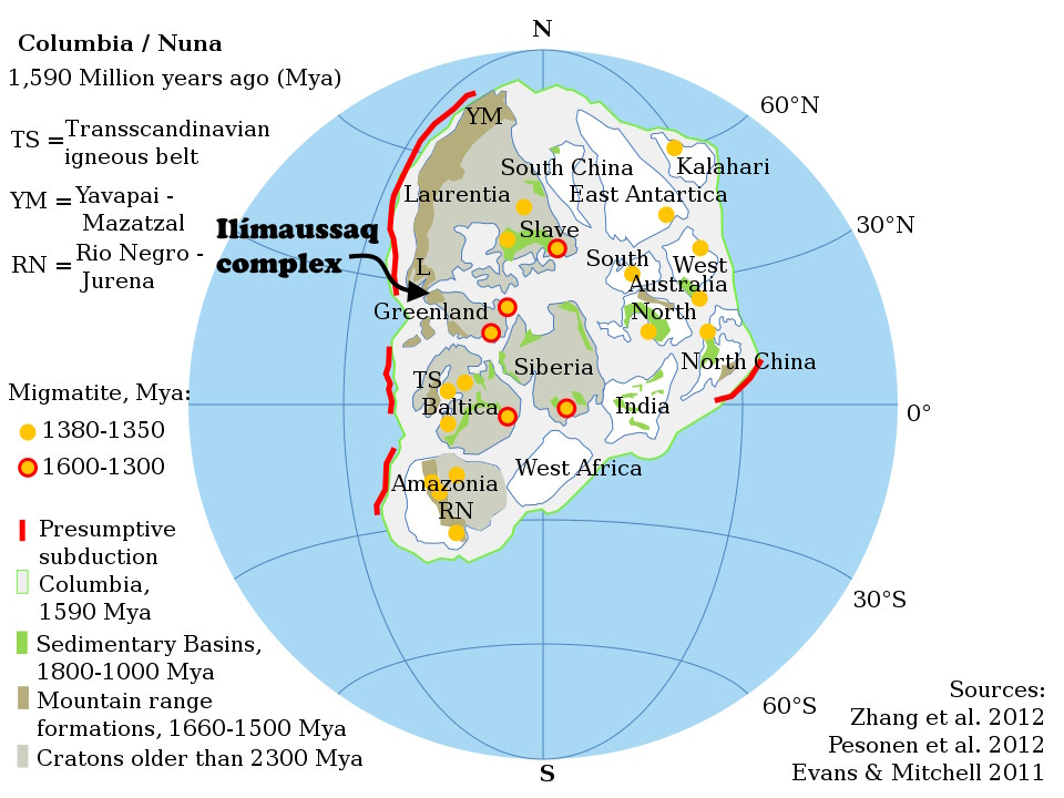
It was named for its discovery location, Tuperssuatsiat Bay, Greenland, whence it was described in 1984 (Karup-Møller and Petersen, 1984, Tuperssuatsiaite, a new mineral species from the Ilímaussaq intrusion in South Greenland: Neues Jahrbuch für Mineralogie, Monatshefte 1984: 501-512). The Ilímaussaq intrusive complex is a jargon-lover’s dream and headquarters for unpronounceable names (to be fair, I can pronounce them, but I suspect it would be high comedy for native Greenlandic speakers). It is an alkalic layered igneous intrusion dated to 1,160 million years ago, late middle Proterozoic time (Sørensen, 2001, Brief introduction to the geology of the Ilímaussaq alkaline complex, South Greenland, and its exploration history: Geology of Greenland Survey Bulletin, vol. 190). The intrusion was related to the Gardar Rift System, which formed as the early Supercontinent Columbia (also called Nuna) broke apart.
Columbia assembled about 2,100 to 1,800 million years ago and broke apart from about 1,300 to 1,100 million years ago. (Graphic by Alexandre DeZotti, Wikipedia, licensed under the Creative Commons Attribution-Share Alike 3.0 Unported license.)
The Ilímaussaq complex is home to at least 241 mineral species including a remarkable 38 for which it is the type locality (where the mineral was first found and/or described), even though it only covers about 140 sq km (50 sq mi, about twice the size of Manhattan Island, New York). The type locality minerals include such strange things as hydroxylgugiaite, karupmøllerite-Ca, and Nakkaalaaqite, in addition to tuperssuatsiaite. Nine of those minerals are found in the Ilímaussaq intrusive complex and nowhere else on earth. Many also concentrate radioactive and rare-earth elements.
Tuperssuatsiat Bay is about 100 km from the famous mineral locality at Ivigtut (Ivittuut), another spectacular source for rare minerals. Both are within the Gardar Rift System and date to about 1,100 to 1,300 million years ago. As near as I can tell, it looks like the Gardar Rift was a failed rift, meaning a full ocean did not develop there and the adjacent parts of what are now Greenland pretty much stayed together, although broken, while other pieces of Columbia did separate completely.
After Columbia broke apart, many of the pieces re-assembled into the supercontinent Rodinia about 1,260 to 900 million years ago. It in turn broke up 750-633 million years ago. (It’s what supercontinents do.)
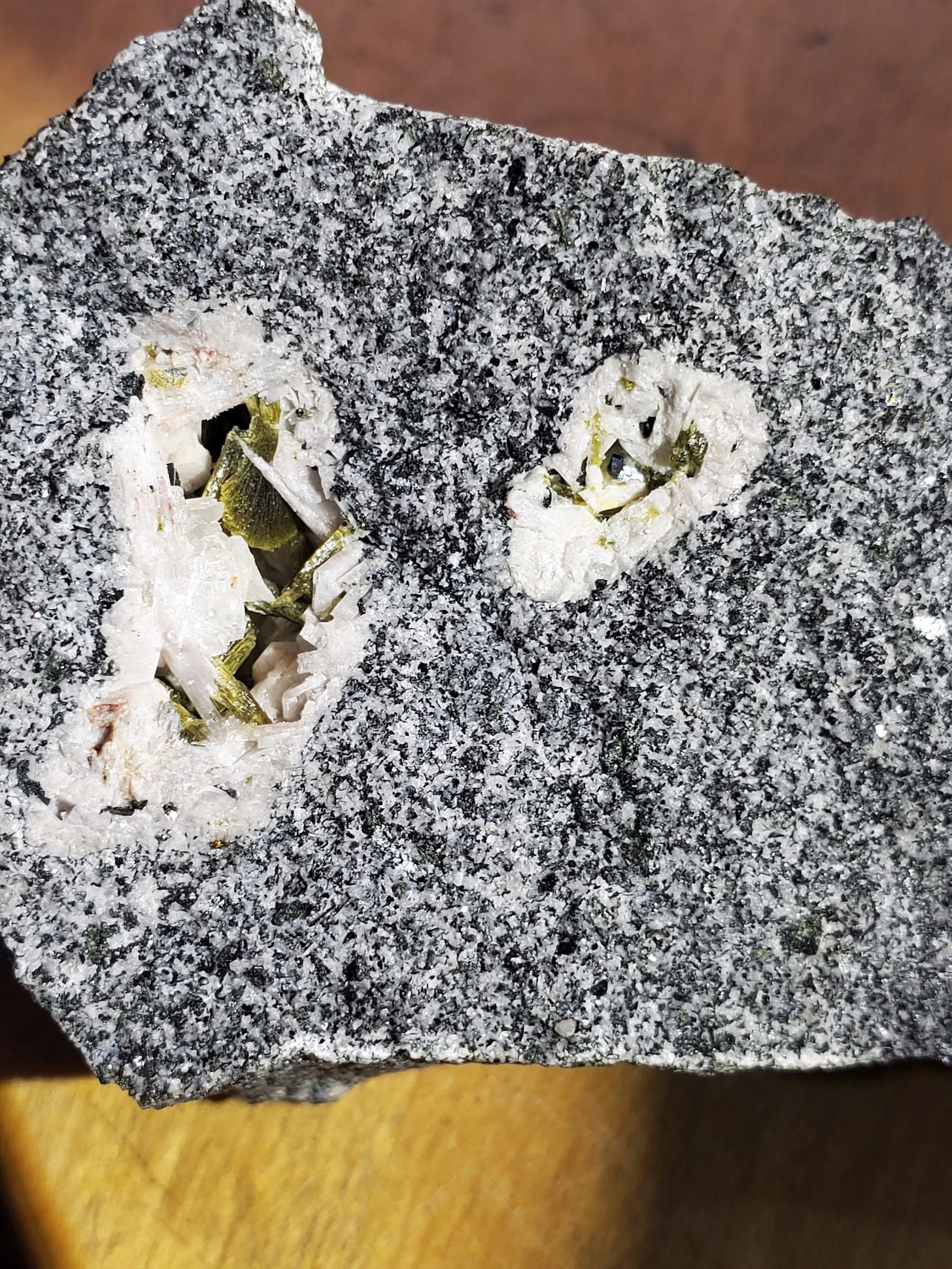
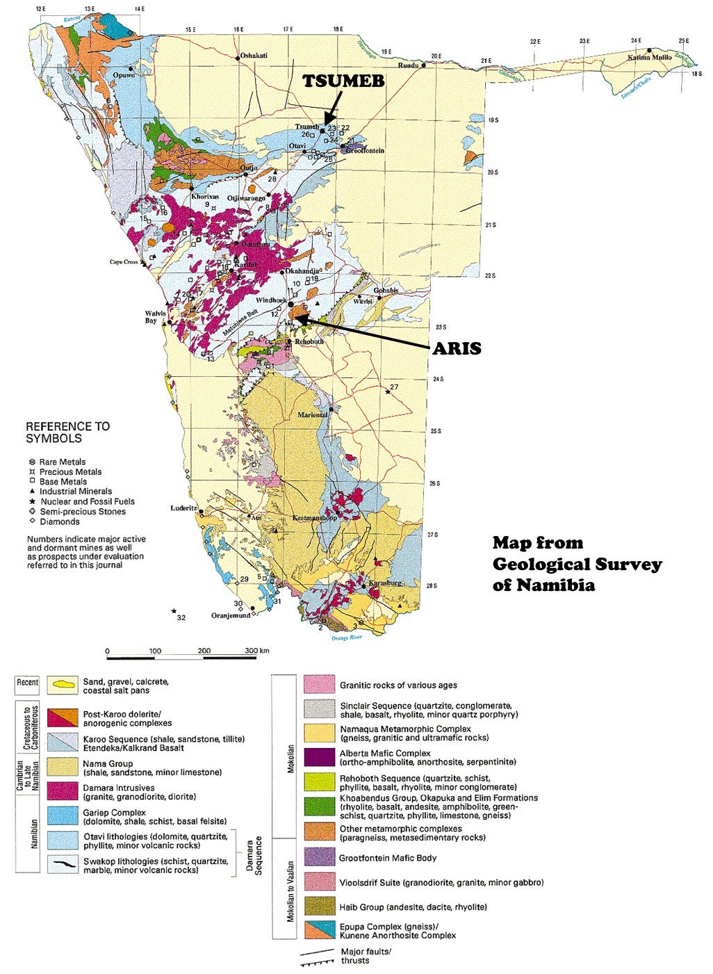
But my specimen isn’t from Greenland. It’s from the Aris Quarries, near Windhoek, Namibia, where tuperssuatsiaite was identified in abundance in the early 1990s. There, the tuperssuatsiaite fills miarolitic cavities in a phonolite. “Miarolitic cavities” are late-stage openings in cooling igneous rocks, places where the last volatile chemicals (often those relatively incompatible with the primary rock-forming elements, like silicon) finally crystallize. The word probably derives from an Italian name for a particular granite with spots in it like millet seeds, miglio in Italian, but the etymology is complex and uncertain. “Phonolite” (Greek for ‘sounding stone’ for the clinking sound it makes when pieces are banged together) is an igneous rock low in silica and rich in alkali elements (sodium and potassium) much like the rocks of the Ilímaussaq complex; it’s the relatively fine-grained analog of nepheline syenite.
Aris also has a lot of strange minerals, although only 6 type locality minerals. It is arguably more famous for its tuperssuatsiaite than is Greenland. Of the 216 photos of tuperssuatsiaite on MinDat, 196 are from Aris.
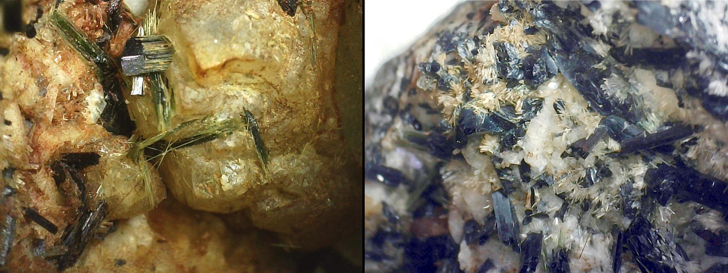
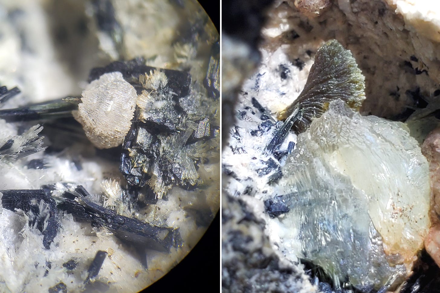
(Left) Black to green aegirine prisms and fibers on possible brown catapleiite. (Right) Pretty sure this is ellingsenite on aegirine.
(Left) I think this is a corroded ball of fluorite on aegirine with ellingsenite. (Right) The greenish fan in the background is probably epidote. The whiter mass in the foreground might be fluorite or analcime.
Other specimens that I have from Aris contain white sprays of probable ellingsenite (sodium-calcium silicate, described in 2011, with Aris as the type locality; but it might be pectolite), green fans of epidote, abundant green to black prisms of aegirine, hexagonal corners of arisite, probable natrolite, possible fluorite, maybe some corroded brownish catapleiite (calcium-zirconium silicate), and several other things. In the photos of tuperssuatsiaite the subtle pink colors in the vugs are tiny bits of villiaumite, sodium fluoride, analogous to halite, sodium chloride, common salt.
The phonolite at Aris is vastly younger than the Ilímaussaq complex, at somewhere between 33 and 77 million years old (Marsh, 2010, The geochemistry and evolution of Palaeogene phonolites, central Namibia: Lithos, V. 117, 1-4, 149-160). Its tectonic origin is unclear, but alkaline igneous rocks like these are often associated with rift processes, as are those in Greenland even though they are nearly a billion years older.
In Namibia, the Aris phonolite might be a continuation of the Cretaceous rifting that opened the South Atlantic Ocean, or it might represent a weakness in the South African Crust, a zone where the continent “tried” to break, as it is today along the East African Rift System. Aris lies in the Damara Belt, a zone where both compression and extension have occurred in the geologic past, so it may persist as a weak zone. The famous Tsumeb mineral deposit is in the Damara Belt as well, although it’s about 400 km north of Aris and the mineralization there is in rocks about 540 million years old. The Damara Belt is part of the Pan-African Orogeny, the collisions that took place after the supercontinent Rodinia broke apart about 650 million years ago. The Damara Belt contributed to the assembly of Gondwana (Africa + South America + Antarctica + India + Australia).

Despite all the comings and goings, I don’t think the areas that now are southern Greenland and central Namibia were ever very close to each other on the earth’s surface. Just two examples of similar geologic history, widely separated in both time and space.
Why tuperssuatsiaite rather than any other sodium-iron-manganese silicate? I have the impression that manganese silicates in general are not very common (except for spessartine, the Mn-Al garnet), and I suspect that usually they combine with calcium or other elements, requiring exceptional concentrations of sodium (such as we find in these unusual rocks) to make tuperssuatsiaite or a handful of other rare minerals. So the easy answer is that the chemical, pressure, and temperature conditions were proper for the formation of tuperssuatsiaite. That’s correct, but also a cop-out. Exactly why tuperssuatsiaite forms is not really evident, at least to me.

What use is it? Apart from its scientific information and value as a collectible, I imagine there’s no commercial use for tuperssuatsiaite. If you could take all the tuperssuatsiaite that exists and put it in a box, I’d be surprised if it added up to 200 pounds of it. But its close relative, palygorskite, (Mg,Al)2Si4O10(OH) · 4H2O, also known as attapulgite or fuller’s earth, is a non-swelling clay that is highly absorbent and is used in kitty litter, drilling mud, and in environmental clean-up situations. In tiny but critical amounts, it is used in medicines, as a pesticide carrier, and in animal feed. At the Pantex nuclear weapons plant near Amarillo, Texas USA, a subsurface clay layer rich in attapulgite blocks contaminated water from reaching the Ogallala Aquifer. As fuller’s earth, it was used by early Mesopotamians and others to “full,” or clean, shrink, and prepare woolen cloth.

Offshore Walvis Bay in central Namibia, there’s another layered igneous intrusive body that may be similar to (and larger than) the strange rocks in Greenland and at Aris. Its layers show up really well on seismic data, suggesting an interesting target of layered sedimentary rocks for oil and gas exploration. But it is also a huge, circular gravity high (very dense rocks) and magnetic high (a lot of magnetite); we used it at Gulf Oil as an example of why you don’t rely on just one geophysical method.
After much effort, I think I may have the pronunciation of tuperssuatsiaite down. Now to get back to Eyjafjallajökull.




Excellent article again Richard!