The Pryor Mountains in south-central Montana and north-central Wyoming are the northwesternmost tectonic continuation of the Big Horn Mountains uplift which lies to the east and southeast. The entire system is part of the breaking of the Archaean Wyoming Craton by collisions during the Laramide Orogeny (about 80 to 55 million years ago) and probably more importantly, because of the change in angle of the downgoing subducting Farallon Plate. When that angle became significantly lower (flatter) than normal, stresses were transmitted far east into the North American Plate allowing the crust in Wyoming and adjacent areas to break in huge mountain-range-size blocks.

The Uinta, Wind River, Owl Creek, Big Horn-Pryor, Beartooth, and other ranges, plus the Black Hills, are all the result of the Laramide breaking. Some of the faults that bound the uplifts and adjacent basins have as much as 45,000 feet of vertical offset (although the faults themselves are rather low-angle at depth, not oriented vertically).

In the Pryor Mountains, the uplift was not as intense as in the Big Horns to the southeast, where the ancient Archaean core of the mountains is exposed. Near-surface rocks in both the Montana and Wyoming portions of the Pryor Mountains include extensive exposures of the Mississippian age (around 330 million years) Madison Mission Canyon Limestone. Those rocks were uplifted at least once before the Laramide Orogeny, enough to allow for karst development: caves, fissures, and other solution features, into which the overlying limestone collapsed to form extensive breccias (breccia is an angular conglomerate; the word comes from Italian for “rubble” or “broken fragments”).
Fluids that probably came from late Laramide igneous activity concentrated uranium (which is typically widespread but not often concentrated in some sedimentary rocks) and deposited it in some of the fractures and other pore space in the Mission Canyon breccia, enough to make for economic deposits of uranium that were exploited in Montana and Wyoming mostly in the 1960s. According to Montana Bureau of Mines & Geology Special Pub. 28, most of Montana’s small uranium production came from occurrences in the Pryor Mountains. Alternatively, the uranium concentrations may derive from glacial water leaching “volcanic ash deposited on an exposed Madison Limestone surface earlier in the Tertiary” (Patterson and others, 1988, Mineral Resources of the Pryor Mountain, Burnt Timber Canyon, and Big Horn Tack-On Wilderness Study Areas, Carbon County, Montana, and Big Horn County, Wyoming: USGS Bulletin 1723).
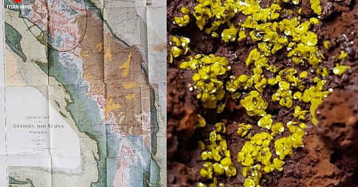
Tyuyamunite is a hydrated calcium uranate-vanadate, Ca(UO2)2(VO4)2 · 5-8H2O. Its canary-yellow color is typical for uranium-bearing minerals, although my specimen has probably dehydrated to metatyuyamunite, a visually identical mineral with fewer water molecules in its structure. Tyuyamunite occurs in multiple localities in the Pryors in Montana and in the northwestern extent of the Big Horns east of the Pryors in both Montana and Wyoming; my specimen is from the Titan Mine in north-central Big Horn County, Wyoming, where it was collected by Chuck Borland in 1969.
Today, the United States is dependent on imports for more than 95% of the uranium we use in nuclear power plants (source: US Energy Information Administration). Sources in 2022 were Canada (27%), Kazakhstan (25%), Russia (12%), Uzbekistan (11%), and Australia (9%), with 6 other countries (Germany, Malawi, Namibia, Niger, South Africa, plus domestic US production) accounting for an additional 16%. In May 2024 uranium imports from Russia were banned, effective in August 2024. That (and generally high energy prices, increased demand, and low inventories) has made the price of uranium surge from about $25-$30 per pound since 2016 to near $90 per pound in mid-2024.
The map of the Big Horn mountains at the top is by N.H. Darton (USGS Prof. Paper 51, 1905). I’ve enhanced the Montana-Wyoming border and circled the general area of uranium mining, all of which is now abandoned. The light blue color represents the Mission Canyon limestone, and the brown color southeast of the oval is outcrops of the Precambrian core of the Big Horn Mountains. The Pryor Mountains lie just off the northwestern edge of this map.
The mineral name tyuyamunite is from its type locality, Tyuya-Muyun, Kyrgyzstan. The location was likely exploited for copper as early as the Bronze Age. The placename is probably from Kyrgyz for “camel’s hump,” and the occurrence there is in Mississippian-age limestones, host rock similar to that in the Pryor Mountains.
The Pryor Mountains were named for Pryor Creek, which was named by William Clark for Sergeant Nathaniel Hale Pryor (1772-1831), a member of the Lewis & Clark Expedition. The native Crow name for the range is Baahpuuo Isawaxaawuua ("Hitting Rock Mountains") because of the abundance there of chert for making projectile points, in either the Phosphoria Formation or in thin layers and nodules in the Mission Canyon Formation (or both). An alternative Crow name for the Pryors is translated as “Shoot-the-Rock Mountains”.


