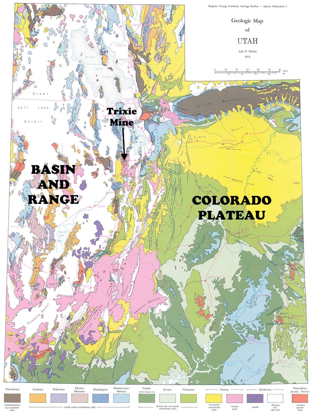
The small Tintic Mountain range near Eureka, Utah, is along the boundary between the solid, relatively unbroken Colorado Plateau to the east and the shattered Basin and Range Province to the west. The Tintic Mountains comprise a high-standing block (a horst) with adjacent down-faulted basins (grabens) that formed when much of western Utah and most of Nevada were pulled apart, beginning about 34 million years ago and continuing today.
The rocks in the Tintics are much older, including the Lower Cambrian Tintic Quartzite and limestone of the middle Cambrian Ophir Formation, around 510 million years old. Equivalents of those layers extend from Canada to Mexico and represent the old, long marine coastal margin of the North American continent. The Tintic Quartzite (actually a tightly cemented sandstone) is the equivalent of the Flathead sandstone here in Montana, and the Tapeats sandstone in the Grand Canyon. That vast sheet of sand extends as far east at New York, where it is called the Potsdam.
Central Utah was relatively quiet tectonically until the Mesozoic, around 180 million years ago, when collisions and subduction to the west began to push the western rocks to the east. Even more recently, and ultimately related to the tectonic activity along the western margin of the continent, igneous activity during the Oligocene, about 33 million years ago (as the basin-range faulting was beginning), mineralized those old Cambrian sedimentary rocks (Morris and others, 1979, General geology and mines of the East Tintic mining district, Utah and Juab counties, Utah, with sections on the geology of the Burgin mine and the geology of the Trixie mine: USGS Professional Paper 1024).
The result is the Tintic Mineral District, a rich gold-silver-lead-zinc mining region. It’s subdivided into several districts including the East Tintic where the Trixie Mine has recently been reactivated. My blue and green minerals shown here are from the Trixie Mine, collected by Roman Wayne Zugaza and given to me by his grandfather, Roman Zugaza.
Although the blue-green mineral association would be (in a simple deposit) something like azurite and malachite, here it is most likely the unusual minerals xocomecatlite (green) and teineite (blue). Both are hydrous copper tellurates. It’s definitely not malachite or azurite as neither mineral in the specimen effervesces in acid.

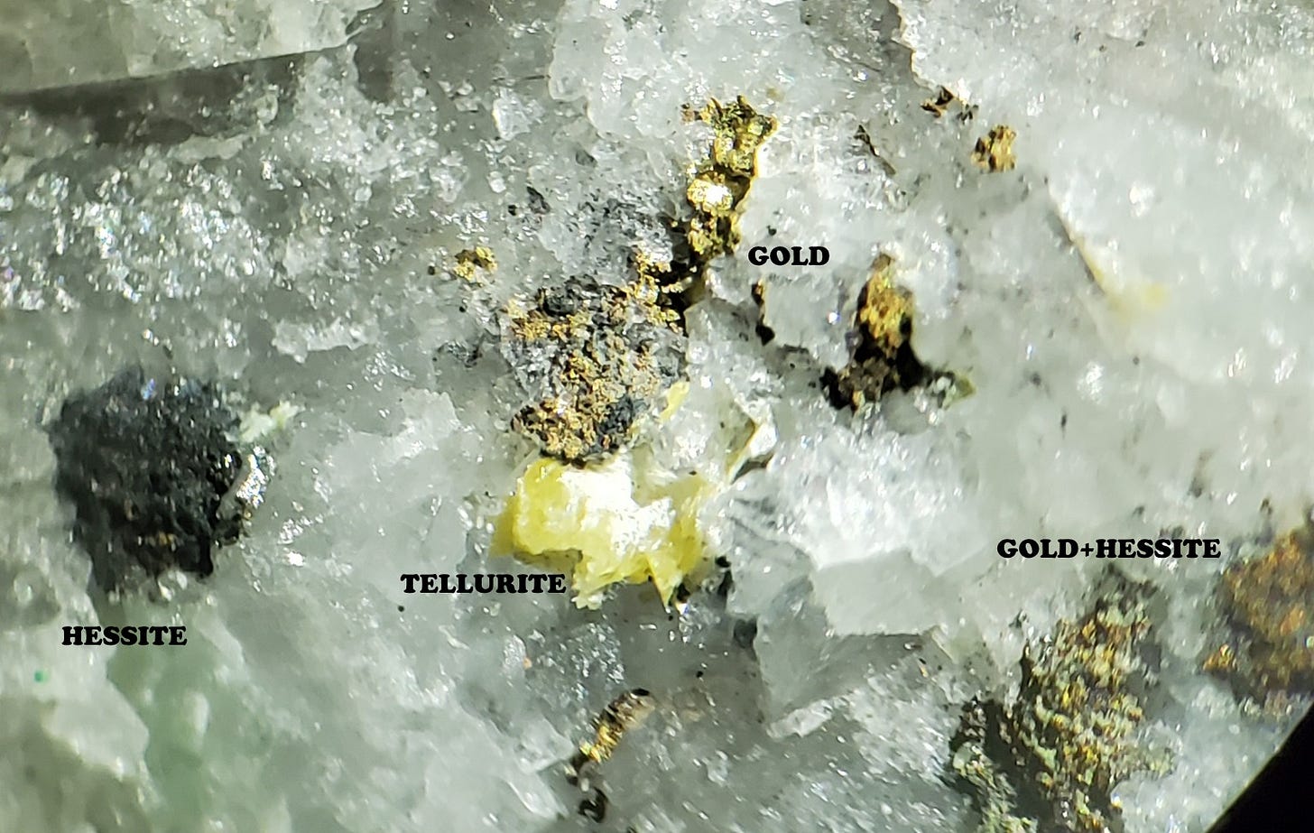
The specimen includes native gold and likely gray-black hessite (silver telluride) which comprise the dark spots in the sample. The yellow material is probably tellurite, tellurium oxide; it might be paratellurite, the same chemistry but tetragonal where tellurite is orthorhombic crystallography.
The white substrate is mostly quartz but there are also some pseudo-cubic colorless crystals that I think are barite. All in all, a fascinating specimen.
Teineite, Cu2+(Te4+O3)·2H2O, was named after its 1936 discovery locality, Teine Mine, Hokkaido, Japan. Xocomecatlite, Cu3(TeO4)(OH)4, is from Nahuatl xocomecatl, grapes, alluding to its occurrence in clusters of green spherules, although at the Trixie Mine it seems to occur mostly as crusts. It was first described in 1975 (Williams, S. A., 1975, Xocomecatlite, Cu3(TeO4)(OH)4, and tlalocite, Cu10Zn6(Te6+O4)2(Te4+O3)(OH)25Cl · 27H2O, two new minerals from Moctezuma, Sonora, Mexico: Mineralogical Magazine, 40 (311) 221-226).


very cool! thank you!