I keep seeing all these “new” things about Zealandia. I have to brag that I reported on it almost seven years ago. This post is modified slightly from a History of the Earth podcast in January 2018.
Zealandia isn’t a quirky TV show modeled after Portlandia. It’s the 7th largest continent on earth.
We’re not talking continents in the geographic sense, really large land masses like Africa and South America, but we are talking about continental material in the geologic sense, even though most of it is submerged beneath the ocean.
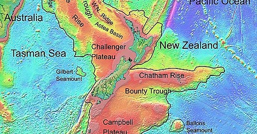
Zealandia is centered on New Zealand, and in some ways, it’s been known for decades, ever since good charts of subsurface bathymetry were created. Those data show a complicated mix of rises and troughs on the sea floor around New Zealand, including the Lord Howe Rise in the Tasman Sea between New Zealand and Australia, the Campbell Plateau east of New Zealand, and other highs and lows. The map at the top of the post is topography and bathymetry, the surface of that region.
Although the ocean floor around the globe is diverse, with seamounts and trenches, fault zones and piles of volcanic rocks here and there, on the whole oceanic crust is deep and uniform, or at least varying broadly and predictably. These relatively small-scale high plateaus on the ocean floor around New Zealand are unusual.
Let’s define a continent. Geographically, it usually means a large land mass. “Large” is subjective, but Australia, at about 9 million square kilometers, is considered to be the smallest continent. And the count depends on whether you separate Europe from Asia, or just say Eurasia as one, and other conventions. Many would say that a degree of isolation and separation also defines a continent, so Eurasia should be one, together with Africa, North America, South America, Antarctica, and Australia, for a total of six. Forget all that. We’re looking geologically at places made of continental crust, the generally lighter, silica-rich material in contrast to oceanic crust, which is usually denser and more iron-rich.
By that geologic definition, all the conventional continents really are mostly continental crust too. All well and good. There are numerous smaller, separated areas of continental crust that are usually called microcontinents. Madagascar is probably the best example of a microcontinent, but there are lots of them, and you can get into plenty of arguments about whether a piece like, say, Greenland, is or is not fully a part of the North American continent.
So, let’s go to Zealandia. In 2017, Nick Mortimer and colleagues, writing in GSA Today, pretty much laid any argument to rest, as far as I’m concerned. There’s abundant evidence to say that there is a large, diverse terrain centered on New Zealand but 94% submerged, which is mostly continental crust. It adds up to about 5 million square kilometers, comparable in size to Arabia and India, sub-continents that are connected in one way or another with full-fledged continents. Zealandia is close to, but clearly separated from Australia, and Mortimer and others make a convincing case that it should be considered the seventh continent, six times larger than Madagascar, the biggest discrete microcontinent.
So if continental rocks are lighter, which accounts for them being for the most part above sea level, why is most of Zealandia under water? The crust there is thinner, so it doesn’t rise as high as that on most continents, and it has been stretched and broken, partly rifted apart during a long complex history.
Zealandia was probably originally part of the supercontinent of Gondwana, attached to eastern Australia and West Antarctica, when those two continents were fully connected to each other about 105 million years ago, in Early Cretaceous time. That margin of Gondwana, thousands of kilometers long, was a subduction zone somewhat like today’s Andes, with an old Pacific oceanic plate diving beneath the Gondwana continental crust. There would have been a volcanic mountain range there, recorded in Zealandia as a surviving string of granitic rocks, batholiths similar to those that developed in western North and South America during Mesozoic and Cenozoic time and continuing to this day.
Gondwana began to be rifted apart by about 85 million years ago, Late Cretaceous time. It appears that one of the first parts to go from this part of the supercontinent was what is now Zealandia, a long narrow ribbon along the coast of the continent. Australia and Antarctica probably began to separate at about the same time, but that was initially a rather slow break-up that wasn’t complete for close to fifty million years.
The idea of a long narrow ribbon of continental crust rifting off a continent has plenty of precedents. During the Ordovician, the Avalonian ribbon rifted away from what is now northwest Africa and ultimately collided with North America, where it forms parts of Newfoundland, Nova Scotia, and New England today. More recently, a string of continental fragments rifted off what is now eastern Arabia and Africa, to collide with Eurasia to form the cores of Turkey, Iran and Afghanistan today. It’s also possible that one or more “ribbon” continents broke off what is now northern India, to begin to amalgamate with Eurasia in today’s Himalayas, even before India itself collided.
The rifting that split Zealandia off Gondwana is recorded in sedimentary rocks. The initial rifting may have begun the crustal thinning and breaking of Zealandia that we see today, but some of that may have developed later. Because Zealandia was (and is) in a zone of complex interactions among small and large continental and oceanic plates, it’s not really surprising that it would have undergone quite a bit of tectonic and crustal modification. Today, the main part of Zealandia that’s above sea level, New Zealand, contains the Alpine Fault, a huge strike-slip fault similar to the San Andreas. The Alpine Fault is ripping Zealandia apart, but even that helps us recognize Zealandia as a small continent. Mortimer and his colleagues identified rock types in the sea floor on both sides of the Alpine Fault – rock types that can be correlated with each other, and that reflect the predicted offsets you’d expect from the Alpine Fault.
I think Mortimer and his colleagues have made the case quite convincingly that we should indeed think of Zealandia as a continent, geologically speaking, even though most of it is under water. Reference: Mortimer and others, 2017, Zealandia: Earth’s Hidden Continent: GSA Today, 27:3, p. 27-35. See also Zealandia: Our Continent Revealed, by Campbell and Mortimer, 2014.
For an engaging, highly human report by a geologist exploring exceptionally challenging terrain to seek the information to help establish the connections proving Zealandia’s existence, see Mighty Bad Land: A Perilous Expedition to Antarctica Reveals Clues to an Eighth Continent, (2023) by Bruce Luyendyk.
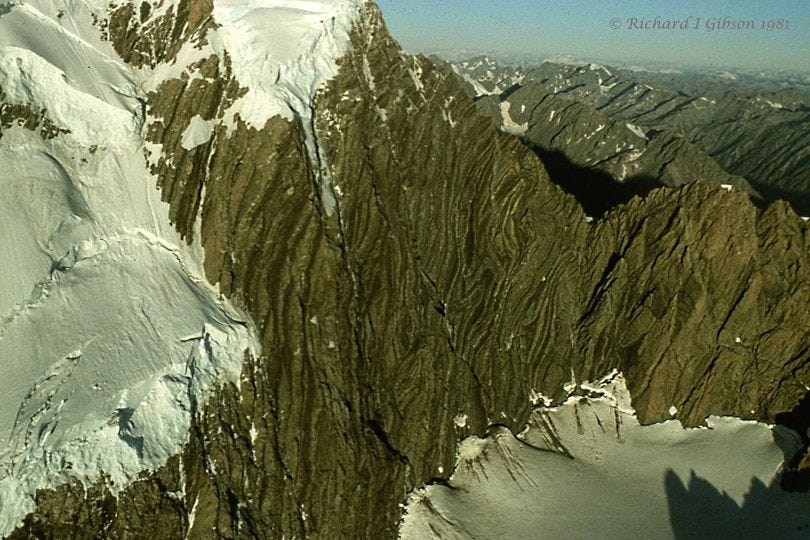
The Endeavour Col Fold System on the south flank of Mt. Cook, New Zealand, is along the Alpine Fault System that splits Zealandia. Endeavour Col is the low notch at right center in the photo above, with the dark shadow behind it; the word “col” is ultimately from Latin for “neck.” The rocks involved are the Torlesse Greywacke, a thick pile of poorly dated sediments laid down over the vast time from the Carboniferous Period to the Jurassic, a span of time approaching 200 million years or so from about 330 to 142 million years ago.
Greywacke (from German for “grey rock”) is a general term for poorly sorted (meaning there’s a wide range of grain sizes, from mud to pebbles or larger), diverse sandstones and siltstones that are much more than plain beach sand. They usually have rock fragments, feldspars, and clay in them, so we call them “immature” versus a nice clean quartz sand which would be “mature” because all the wimpy unstable weak things like rock fragments, mica, and feldspar have weathered away or been winnowed out. Graywackes rarely contain fossils. Often, but not always, graywackes are deposited by submarine slurry flows called turbidity currents that often represent slumps and flows that mix the different grain sizes. Rivers and waves usually work like a miner’s gold pan to separate gravel from sand from silt from mud, so conglomerates, sandstones, siltstones, and mud rocks like shale may interfinger, but generally the grains are not intimately intermixed as they may be in greywackes.
Zealandia was attached to Australia and the rest of Gondwana when a lot of the Torlesse Greywacke was deposited by turbidity currents carrying sediment from highlands in what is now northeastern Australia into gigantic deep-sea fans, perhaps something like the Bengal (or Ganges) Fan today, offshore Bangladesh, India, and Myanmar. That steep-edged continental margin of Gondwana was apparently quite long-lived, since the pile of Torlesse sediments is many thousands of meters thick and covers more than half of present-day subaerial New Zealand. Even though individual turbidity currents represent remarkably fast deposition (fast in geologic terms), here the deposition continued for many tens of millions of years.
The Torlesse Supergroup rocks were folded and metamorphosed first in the Cretaceous Rangitata Orogeny (recall that “orogeny” means mountain building), about 100-120 million years ago. They were not very intensely metamorphosed, so generally these rocks are not gneiss or schist, but would be called argillites or quartzites, and the layering you see in the photo probably represents original sedimentary bedding rather than the metamorphic foliation you see in gneiss and schist. Technically, the metamorphic grade or intensity is mostly prehnite-pumpellyite to greenschist, which are on the low (to moderate) end of the heat and pressure that make metamorphic rocks. (More information in Findlay & Sporli, 1984, Structural Geology of the Mt. Cook Range and Main Divide, Hooker Valley region, New Zealand: New Zealand J. of Geology & Geophysics, 27:257.) In other places in New Zealand, these rocks have indeed been strongly metamorphosed into rocks called the Haast Schist.
The region has undergone at least four different episodes of folding, much of it in the past 20 million years (and continuing) and related to the Alpine Fault. The Alpine Fault slices the South Island of New Zealand along its length just west of Mount Cook, and as it moves, it drags the rocks on both sides of it into both broad-scale and small-scale folds. There’s plenty of faulting, too.
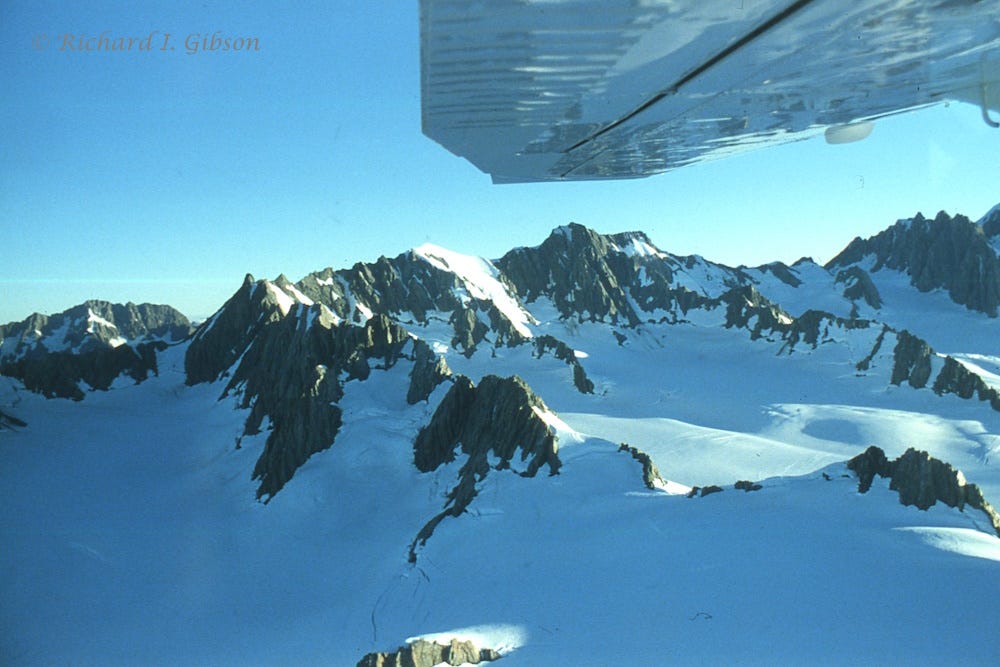
I took the photo of Endeavour Col in 1981, from a four-passenger light airplane. The high point of Mt. Cook (Aoraki) at 3,724 meters (12,218 feet) is somewhat to the left of this view, and the col itself is at 2,819 m (9,249 ft). The snow in the right foreground in my photo is around the head of Noeline Glacier, a tributary to the much larger Hooker Glacier. I know there’s nothing for scale, but that exposed rock face in the photo above is probably about a half-mile (0.8 km) wide. The photos below, from the same flight, show the crest of the range around Mt. Cook.
In most etymologies, Aoraki means “cloud piercer” in the Māori language. It is also the name of a person in the mythology of the Ngāi Tahu (South Island Māori) tribe. In their creation story, Aoraki was the eldest son of Raki, the Sky Father.


Great post of particular interest as I live in the much older greywacke range of the Scottish Southern Uplands (Silurian and Ordovician, raised by the Caledonian Orogeny). Not entirely fossil free as the graptolites here were used by Charles Lapworth to define the Ordovician itself. Great photo of a real greywacke mountain! Ours are just hills.
Given that our two continents have so recently separated, Avalonia ribbon also forms old England as well as New.
excellent, super-enjoyable post! Sharing...