


Life in the USA is not normal. It feels pointless and trivial to be talking about small looks at the fascinating natural world when the country is being dismantled. But these posts will continue, as a statement of resistance. I hope you continue to enjoy and learn from them. Stand Up For Science!
Montana, along with much of the world, is being covered by LiDAR (Light Detection and Ranging) surveys. The information content is quite astonishing and is used for hazard mapping (faults, landslides, flood management, etc.), water resource analysis and planning, terrain modeling, geologic mapping and resource evaluation, cultural resource studies (archaeology), city planning (LiDAR can measure heights of buildings and power lines), forest management, and more. LiDAR uses laser pulses of light at several different wavelengths to generate its imagery.
LiDAR data are acquired from either fixed-wing aircraft or helicopters.
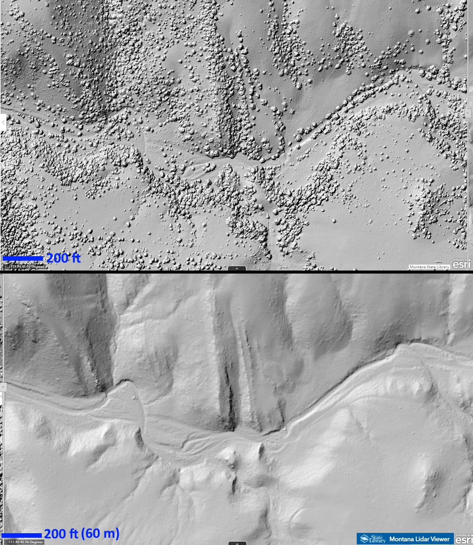
For geology, one of the most useful aspects is the subtle level of measurement. The images at top, from the Montana LiDAR Inventory, are at 1-meter resolution, and even higher resolutions can be achieved. Perhaps even more useful is the effective removal of trees, resulting in an elevation model that shows the interpreted “bare ground.” LiDAR does this by sending multiple laser pulses, some of which reflect from the trees and some of which reflect from the ground around and beneath the trees, with some pulses going through the gaps in trees. The more distant pulses are taken to be from the ground. So LiDAR “sees through trees” by making an inference about which reflections are from the trees and which are from the ground.

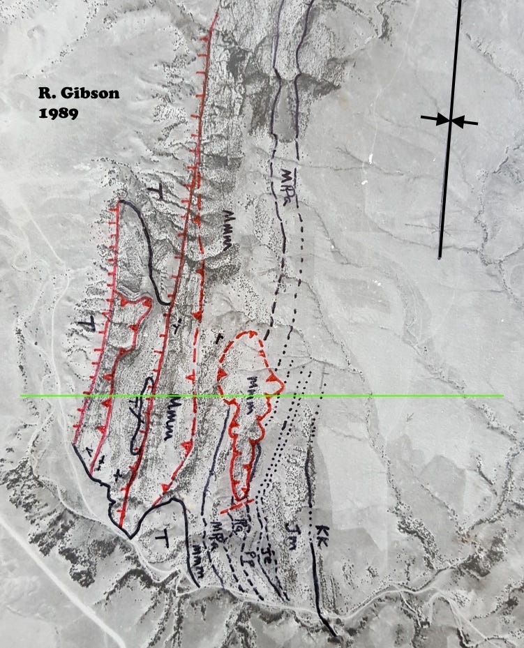
The area I selected from the LiDAR Viewer is along a gulch northeast of Cardwell and east of Montana Highway 69, outlined in red on the published geologic map above. The rock layers here are most of the stratigraphic section from the Mississippian Mission Canyon formation to the Cretaceous Kootenai, and some of the layers are quite thin. They are faulted and steeply inclined and strike slightly west of north-south; the layers are part of a complex syncline whose axis is east of the obvious layers, but which shows up on the snippet of the Bozeman Quad above (the inward-pointing red arrows within the green area just to the right of the red box). Vegetation follows some of the low outcrops, but not all, and in places the vegetation obscures the details of the layered rocks, which are much more evident in the lower LiDAR image in which the vegetation has been essentially filtered out.
Below is my map of this area from 1989, on an air photo base from 1955, shown as the dashed black rectangle on the geologic map above. There are more trees and bushes evident in the upper LiDAR image than were present when this air photo was made in 1955.
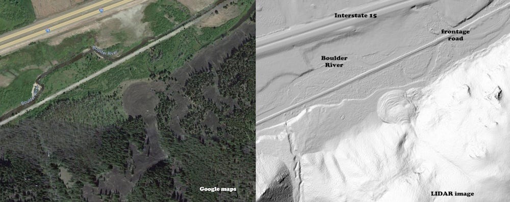
Above is another example comparing a Google maps view to the LiDAR, along the Boulder River near Basin, Montana. It shows a nearly circular landslide in the Elkhorn Mountains Volcanics, and also highlights some of the detail that may not be that evident in the standard photographic image.
A good example of using LiDAR to infer the history of faulting in Montana is a paper by Mike Stickney (2020, Late Quaternary fault scarps near Como Lake, Montana: Northwest Geology 49, p. 71: The Journal of the Tobacco Root Geological Society).
LiDAR can also be collected with drones! The geology and hazard applications are exciting. Check out WA state’s fun story maps on how LiDAR data can be used: https://wadnr.maps.arcgis.com/apps/Cascade/index.html?appid=36b4887370d141fcbb35392f996c82d9
Fascinating