

Life in the USA is not normal. It feels pointless and trivial to be talking about small looks at the fascinating natural world when the country is being dismantled. But these posts will continue, as a statement of resistance. I hope you continue to enjoy and learn from them. Stand Up For Science!
The Phosphoria Formation of western United States is a strange package of rocks. It includes sandstone, black shale, dolomite layers, phosphate rock (phosphorite), bedded chert, siltstone, claystone, breccias, and limestone.
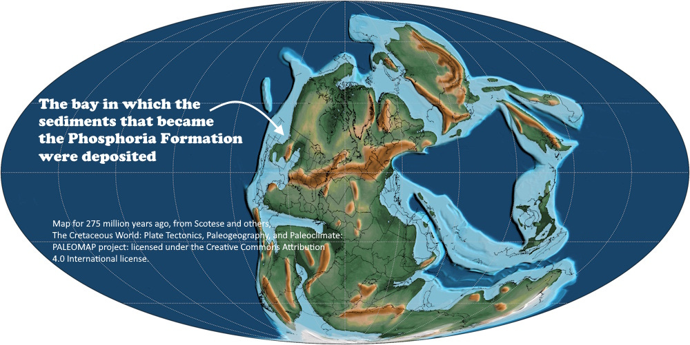
The basin in which the Phosphoria was deposited during the Permian Period extended at times across much of western and southwestern Montana, eastern Idaho, northern Utah, most of Wyoming, and parts of Colorado and Nevada. The package is up to 420 meters (1,380 ft) thick, although in parts of southwestern Montana, most of that diversity of rock types can be found in a package only 100 meters or so thick.
The Phosphoria was deposited over a period of about 9 million years between about 274 and 265 million years ago (Wardlaw, 2015, Gondolellid conodonts and depositional setting of the Phosphoria Formation: Micropaleontology 61:4-5, p. 335-368).
When I first encountered the Phosphoria, during geology field camp in 1969, the standard explanation for the chert and phosphate rock was cold upwelling currents along a relatively steep continental shelf or slope. Something like that is still part of the interpretation, but all those rock types indicate wide-ranging, and probably frequently changing environments (Hein, Perkins, and McIntyre, 2004, Evolution of thought concerning the origin of the Phosphoria formation, western U.S. phosphate field: Chapter 2 in Handbook of Exploration and Environmental Geochemistry Vol. 8, M. Hale, Series Editor: Elsevier). Some of the dolomite was probably deposited in a shallow, restricted, saline, evaporative bay, and the organic-rich black shale, which serves as an oil source rock in the Bighorn Basin of Wyoming, must have formed in an anoxic, poorly circulated sub-basin.
The clastics (meaning “broken pieces”), the sands, silts, and muds, probably came from an exposed upland adjacent to the marine basin, and might represent fluctuating beaches, deltas, and estuaries whose positions moved over time so that the marine environments may have overlapped them at times and in some places. Something like that must have occurred to generate the interlayering of the marine chert and phosphate rock with the terrestrial sediments like sand.
The entire package has also been interpreted as a sag basin near the margin of western North America, sagging because of the impinging of diverse blocks to the west, signaling the onset of tectonic activity in western North America (Wardlaw and Collinson, 1986, Paleontology and deposition of the Phosphoria Formation: Contributions to Geology - University of Wyoming, Laramie). Sea-level changes associated with that incipient tectonic activity could help explain the shifting environments. The Phosphoria depositional basin was fairly close to the equator, but in the Permian southern hemisphere, a major glacial period was in progress, and sea-level changes associated with pulses of glaciation could also be reflected in the rocks here.
The thick beds of chert, chemically precipitated fine-grained silica, probably indicate the presence of abundant microorganisms like radiolarians that produced silicious shells plus siliceous sponge spicules, but given how much chert there is, there must have been a lot of them (Matheson and Frank, 2020, An epeiric glass ramp: Permian low-latitude neritic siliceous sponge colonization and its novel preservation (Phosphoria Rock Complex): Sedimentary Geology 399). Likewise, the white phosphate nodules, ooids, and beds – which are the mineral apatite, calcium phosphate – probably came from abundant life living in the cold waters, distant from sediment influx. The apatite would precipitate depending on the temperature-pressure conditions of the water, probably in water shallow enough for wave action to roll the grains around to produce the nodules, pellets, and ooids (from a word for “egg”). Alternatively, it might be possible that the round nodules and ooids represent reworking of more continuous or concretionary phosphate deposits (Zhang and others, 2021, Origin and evolution of the Late Cretaceous reworked phosphorite in the Sirhan-Turayf Basin, northern Saudi Arabia: Minerals 11(4), 350).
For a bit more about the life in the Phosphoria depositional environment, see this previous post.
The Phosphoria was mined for many years in Montana, Idaho, and Utah for its phosphate as a component in fertilizer. Today the United States mines phosphate mostly from sediments in North Carolina and Florida, but some Phosphoria is still mined in Idaho and Utah. It’s a $2-billion industry annually in the US, but China produces most phosphate rock worldwide with nearly 50% of the world’s output; the US mines about 8% of the world total and is 13% dependent on imports, almost all from Peru.
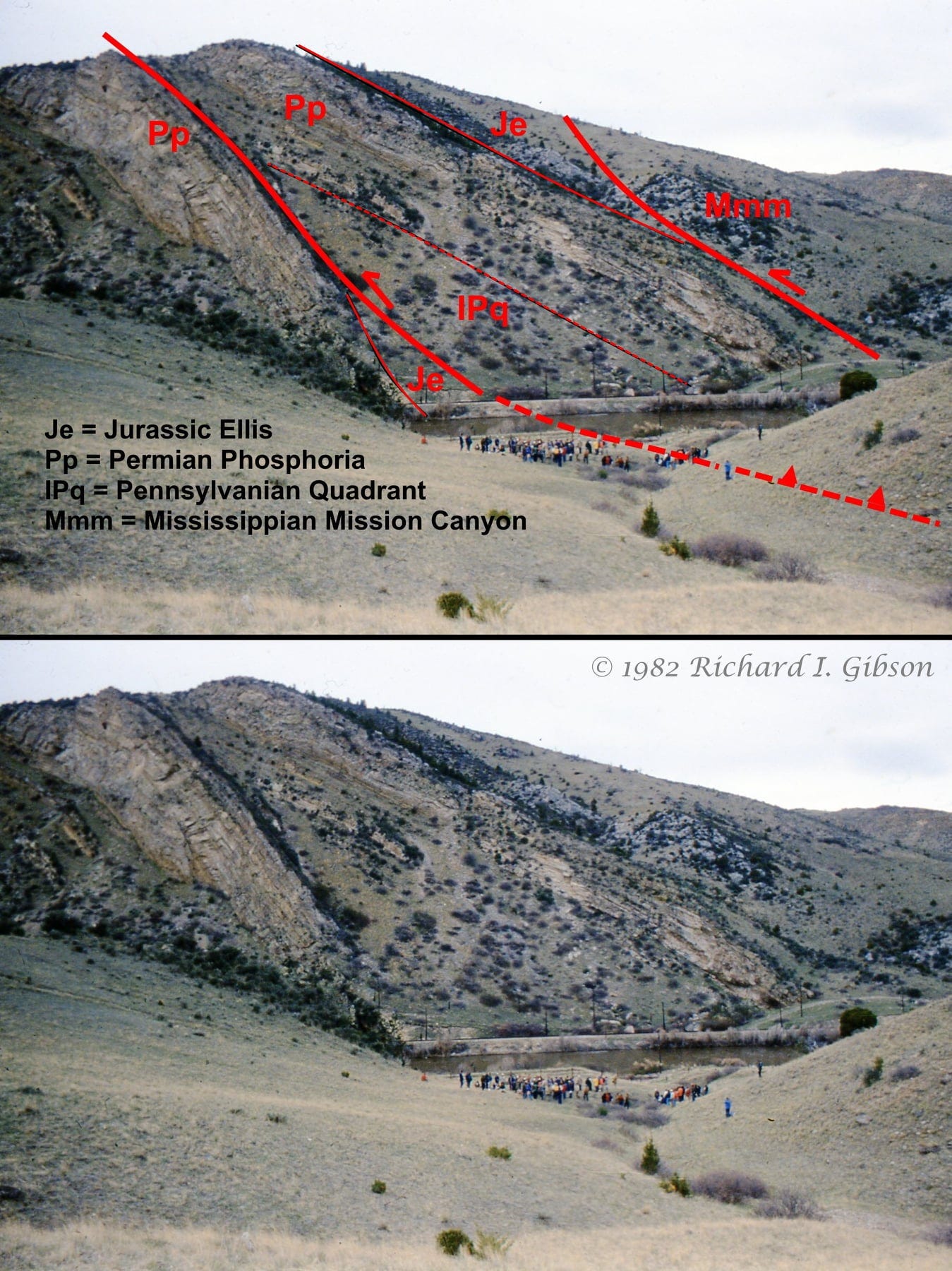
The mechanical behavior of the Phosphoria Formation depends on the thickness and strength of both the entire package and individual units within it. In the photo above along the Jefferson River in southwest Montana, the Phosphoria is mostly one relatively thick, coherent quartz sandstone unit, with only minor bits of the other lithologies. It broke brittlely along the fault shown.
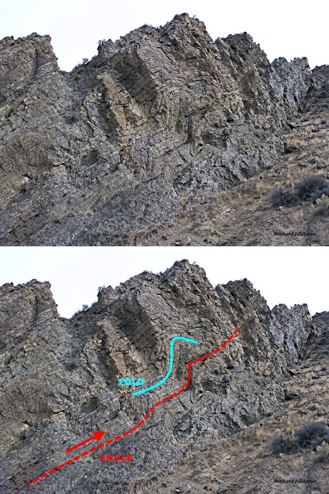
Since chert is fundamentally just dense silica, the mineral quartz, you might expect it to also break in a brittle manner. But the photo above, which is all bedded chert, shows how it can also fold under the right conditions. This is called a fault-bend fold, because the fold is a consequence (a bend) of the space problems created by a brittle break, a fault. The interpretation shows a simplified look; there are probably more faults (and small folds) in there than just one.
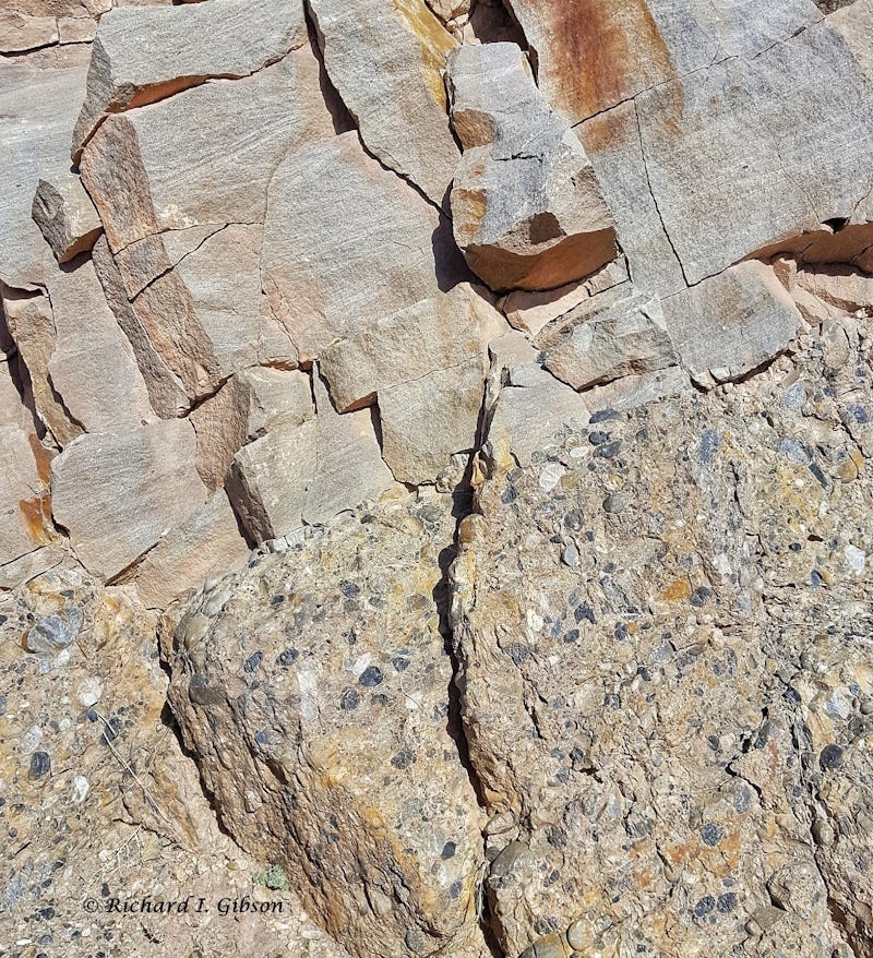
The photo above does not show the Phosphoria Formation. It’s part of the Kootenai Formation, deposited about 115 million years ago, 155 million years after the Phosphoria was laid down. But the pebbles and cobbles (and the dark sand grains) are all chert that was derived from the Phosphoria Formation. This tells us that somewhere not too distant (to transport the coarse pebbles), rocks of the Phosphoria Formation were exposed and eroding 115 million years ago, so that the resistant bits of chert and quartz were carried by streams into piles of sediment that eventually lithified to make the Kootenai Formation, here along the Big Hole River in southwest Montana barely a kilometer from the modern outcrop of bedded chert in the fault-bend fold photo above. The Phosphoria is still eroding today.
This brings back memories of my first professional job, summer field assistant after my sophomore year, about 1967. I was the assistant to a USGS geologist who was mapping several quadrangles in NW Wyoming, mainly to map out the extent and lithology of the Phosphoria. It was a great learning experience. Thank you for your posts.
I recently watched a YouTube (Permian-Triasic Mayhem: Earth's Largest Mass Extinction - https://www.youtube.com/watch?v=VnUq33HCLzU&ab_channel=RoyalTyrrellMuseumofPalaeontology) from 2013. Beauchamp, studying Late Permian rocks in the Sverdrup Basin (Canadian Arctic), has bedded chert composed of predominately sponge spicules in a shallow marine shelf depositional setting as evidence of a shallowing of the carbonate compensation depth and the acidification of the Late Permian oceans (at least locally). Perhaps a mechanism for the banded cherts observed in the Phosphoria? Just a passing thought.