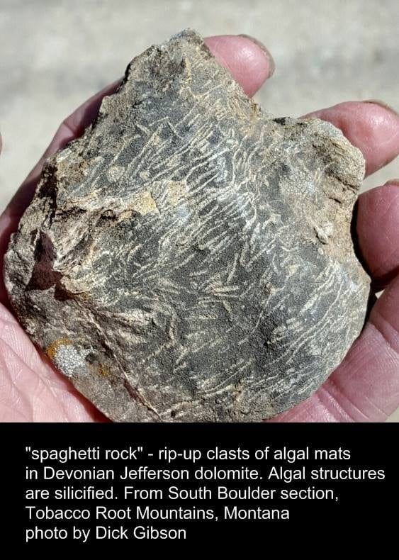
This rock looks pretty boring, as fossils go, but this little rock tells some great stories. The dark part is dolomite, calcium-magnesium carbonate from the Devonian Jefferson Formation of the northern Tobacco Root Mountains of Montana. It was laid down, probably as limestone, calcium carbonate, in an extensive shallow, marginal, sub-tropical sea about 375 million years ago.
The elongate white pieces (“spaghetti rock”) are silica, simple quartz. They represent mats of algae that grew on the near-shore carbonate mud banks of that Devonian sea. Algal mats tend to be fine filaments, which trap the fine sediments that must have washed into the sea – siliceous mud and silt. Each little layer, typically less than a millimeter thick, may represent annual deposition – a wetter season washing more sediment into the coastal mud flat to be trapped by the algal mat, and maybe even killing it. The next year, another algal mat develops, to be killed off by the seasonal influx of sediment. Their presence or absence might also represent periodic algal blooms, dependent on the amount of nutrients present.

So why are they in little pieces? While an algal mat a millimeter thick might not have been continuous for miles and miles, it’s likely that they were continuous for many inches or even feet. They are fragmented in this rock because 375 million years ago, there were storms, or at least tides, aggressive waves, and currents. They would rip up the partly lithified crusts of silica-rich algal mats, depositing them as the jumble you see in this rock.
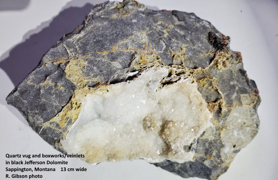
An alternative explanation is that the algal mats had a slightly different texture from the surrounding limy mud, and later silica-bearing water percolated through the rock, selectively silicifying the broken algal mats and leaving the mud rock alone. There are other silicified fossils (corals and others) and quartz-rich zones, almost geodes in places (see photo below), in the Jefferson Formation, so I don’t think this possibility can be ruled out.
This “spaghetti rock” is quite distinctive, and helps geologic mappers convince themselves that they are in the Jefferson Formation, at least in southwest Montana.
Sometime after the limestone was deposited, magnesium-rich waters percolated through changing the limestone to dolomite. The process of dolomitization is poorly understood (at least by me), but it had to happen. Mineralogically it’s easy enough to substitute some Mg for Ca in the calcite of limestone to make dolomite, and magnesium is the 7th most abundant element in the earth’s crust, but where it came from and why it altered the Jefferson Formation while leaving older limestones unchanged is difficult for me to grasp.
So, we can tell that 375 million years ago there was a shallow carbonate sea in southwest Montana, that algae lived near the shore and fine sediment was washing in from a lowland not too far away, that there were storms or other sources of high energy in the waters, that the algal mats became silicified somehow, and that sometime for some reason a bunch of magnesium-rich fluids came by and got into the rock. All from this little specimen. (Well, the age is based on broader information.) Thanks, Jefferson.
The marginal sea in which the Jefferson was deposited during Devonian time extended at least from central North Dakota to Idaho, and south to Arizona and New Mexico. Equivalents of the Jefferson Formation go by different names in other parts of the west: Duperow and Souris River in north-central Montana and in the subsurface of the Williston Basin of North Dakota, and the Temple Butte Limestone in the Grand Canyon. In parts of Utah and Colorado it’s called the Elbert Formation, and in some parts of Montana and elsewhere, the upper part, called the Birdbear Member in southwest Montana, is a full formation of its own.
The famous Bakken formation of the Williston Basin is also Devonian in age but it’s a bit younger than the Jefferson and its equivalents.
The Jefferson Formation is mostly Frasnian in age, the next-to-last stage of the Devonian Period, about 372-380 million years old (Hoffman, 2020, The Devonian sedimentary record of Montana: Montana Bur. of Mines & Geology Special Pub. 122: Geology of Montana, vol. 1: Geologic History).
During or just after the deposition of the Jefferson Formation and its equivalents in the Late Devonian, a major world-wide extinction event took place (the Frasnian-Famennian event, about 372 million years ago ). At the species level, as much as 75% of all life disappeared. The cause of the extinction is uncertain, and may be related to more than one circumstance, including tectonically induced cooling (weathering rocks and deposition of limestones can cool the climate by removing carbon dioxide from the atmosphere), volcanic activity, an impact, and/or the greening of the land as plants proliferated also reducing carbon dioxide in the atmosphere and cooling the climate (and there was a glacial episode near the end of the Devonian).
The Jefferson dolomite in southwest Montana often has a petroliferous (hydrogen sulfide) smell, indicating organic matter in it, and the dark color may suggest that as well. That might (or might not) be an indication of anoxic conditions in the run-up to the extinction event. In the Williston Basin, the Jefferson’s equivalents, the Birdbear and Duperow Formations, have produced about 175 million barrels of oil.
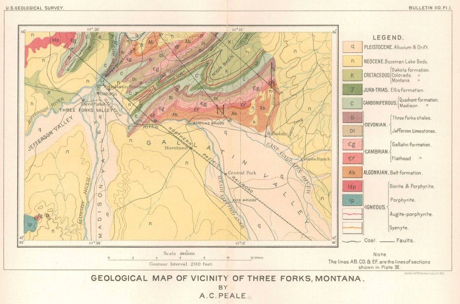
The Jefferson Formation was named by A. C. Peale in 1893 (Paleozoic section in the vicinity of Three Forks, Montana: U. S. Geol. Survey Bull. 110) for occurrences near the Jefferson River, which in turn was named by Lewis & Clark for President Jefferson. Peale’s original published map is below; the scale is too small to show the defining outcrops of the Jefferson near the river west of Three Forks. The Jefferson also crops out in the Horseshoe Hills northeast of Three Forks, along with most of the other Paleozoic strata. Here, it is less dolomitized than elsewhere, so Peale calls it the “Jefferson Limestones.”


