
Pachelm Aulacogen
A failed rift

Life in the USA is not normal. It feels pointless and trivial to be talking about small looks at the fascinating natural world when the country is being dismantled. But these posts will continue, as a statement of resistance. I hope you continue to enjoy and learn from them. Stand Up For Science!
Planet Earth is dynamic, constantly renewing itself through the growth and destruction of its tectonic plates at rift and subduction zones. That’s probably a good thing; the case can be made that life on earth is at least partly a consequence of the diversity of environments produced by plate tectonics (see Ward and Brownlee, 2000, Rare Earth: Why Complex Life Is Uncommon in the Universe: Copernicus Publications).
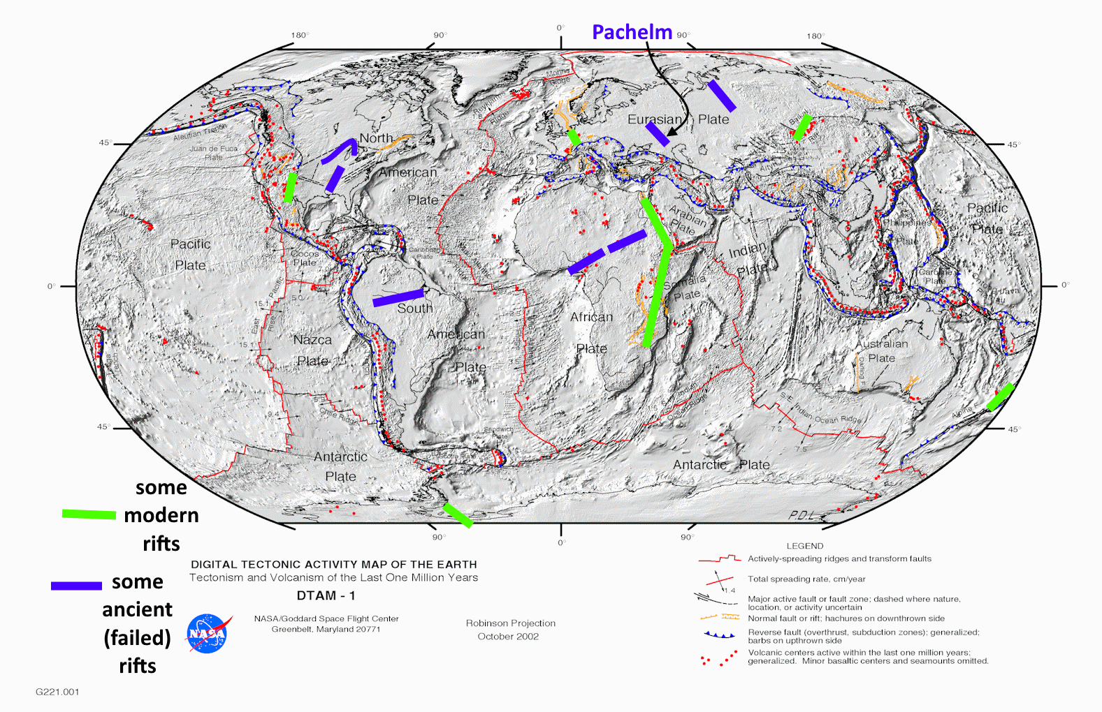
While oceanic crust is generally thinner, weaker, and more uniform than continental crust, continental cratons (from Greek for strong) also break apart and have done so for billions of years. Probably the most well-known active continental rift today is the East Africa-Red Sea System, but there are others including the Rio Grande Rift, the Rhine Graben System, the Baikal Rift in Siberia, the Taupo Rift in New Zealand, and the almost inactive West Antarctica Rift System.
Many continental rifts fail, often along one of three rifts at a triple junction, with the other two branches continuing to break continents apart and go on to form new oceanic crust and ocean basins. One failed example is the Cretaceous Amazon Rift and its analog in Nigeria, the Benue Trough and its extension across Africa; another is the Triassic West Siberian Rift System. In North America, the failed Reelfoot Rift began by Cambrian time and still controls the position of the lower Mississippi River Valley. Even older, at about 1,100 to 1,200 million years, the Mid-Continent Rift broke a zone from Oklahoma to Minnesota and on to Michigan, but it too failed.
These failed rift systems are basically large grabens, relatively narrow troughs down-dropped along parallel to sub-parallel normal fault zones. The word aulacogen was coined by Russian geologist Nikolay Shatsky (1895-1960) in 1946, and it is usually applied to really large down-faulted zones that represent failed arms of tectonic triple junctions, usually within cratons. Thus while you can have grabens developed in any extensional (and sometimes even in compressional) settings, an aulacogen is a particular feature related to plate tectonics. The word is from Greek aulax, a furrow, and the suffix -gen, “born of” or producing.
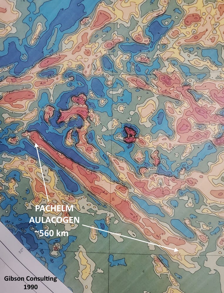
The map at top is the magnetic map of part of the East European (Baltic) Craton. The prominent northwest-southeast linear magnetic feature is the Pachelm (or Pachelma) Aulacogen. North is at the top. The magnetic highs indicate that the graben (aulacogen) contains a lot of magnetic rock, probably mostly basaltic. The magnetic high complex is about 560 km (350 miles) long, but the aulacogen extends somewhat further northwest and perhaps 100 km further southeast, places where the magnetic map tells us it contains less (or no) basalt.
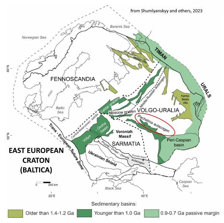
Like other cratons (at least the large ones), the East European Craton is an amalgamation of older, smaller blocks that came together to form it. Shumlyanskyy and others (2023, Detrital Zircon Geochronology of the Volyn-Orsha Sedimentary Basin in Western Ukraine: Implications for the Meso-Neoproterozoic History of Baltica and Possible Link to Amazonia and the Grenvillian—Sveconorwegian—Sunsas Orogenic Belts: Geosciences 13, no. 5: 152) believe features like the Pachelm Aulacogen follow old belts where three smaller blocks came together, named Fennoscandia, Sarmatia, and Volgo-Uralia on their map above. This is expectable, as later faulting often (but by no means always) follows pre-existing weak zones such as the lines of amalgamation of older, smaller cratonic blocks.
The assembly of the East European Craton probably dates to about 1,750 million years ago (Bogdanova and others, 2008, The East European Craton (Baltica) before and during the assembly of Rodinia: Precambrian Research, 160:1-2, p. 23-45). About 1,100 to 900 million years ago, it became incorporated into the supercontinent Rodinia.
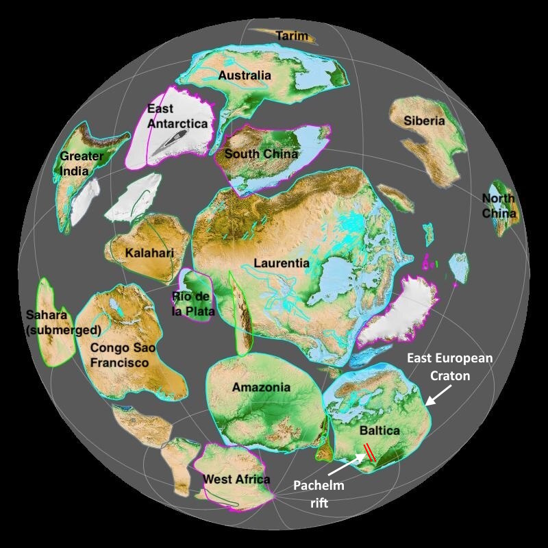
Rodinia began to break apart about 750 million years ago, only about 250 million years after its assembly was complete. As it did so, parts of the East European Craton also started to extend, in the Pachelm aulacogen and elsewhere, but those extensional rifts did not go to completion, and the craton remained more or less intact. The Pachelm and related rifts did accumulate as much as 10,000 meters (32,500 feet) of sediments (Peterson and Clarke, 1983, Petroleum Geology and Resources of the Volga-Ural Province, U.S.S.R.: USGS Circular 885), together with thick piles of basalt as we infer from the magnetic map. The rifting likely broke the crust to depths that allowed magma to rise and erupt and intrude in the Pachelm rift.
Most of the infilling of the Pachelm rift (also called the Ryazano-Saratov depression) probably dates to very late Precambrian time, around 700 to 600 million years ago as Rodinia broke apart. It remained more or less quiescent until the Devonian, when the craton was compressed and some parts of the formerly down-dropped aulacogen were inverted, producing uplifts. It’s obviously had a long, complex history.
The name Pachelma is from a river, town, and province name, but the ultimate etymology is unclear.